Copernicus Trajectory Design and Optimization System
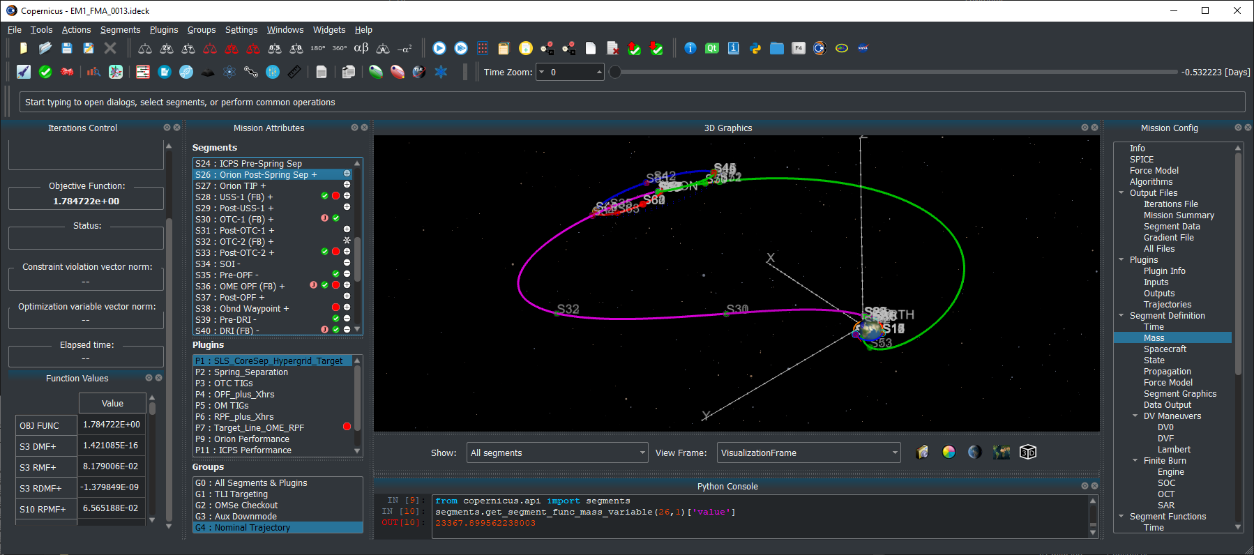
Copernicus, a generalized spacecraft trajectory design and optimization system, is capable of solving a wide range of trajectory problems such as planet or moon centered trajectories, libration point trajectories, planet-moon transfers and tours, and all types of interplanetary and asteroid/comet missions.
Latest News
- January 21, 2022: Copernicus Version 5.2 is now available. This update includes many bug fixes and various new features and refinements.
- June 17, 2021: Copernicus was selected as winner of the 2021 NASA Software of the Year Award.
- March 4, 2021: Copernicus Version 5.1 is now available. This updates includes many bug fixes and various new features and refinements.
- June 26, 2020: Copernicus Version 5.0 is now available. This is a significant update to Copernicus and includes: A new modern Python-based GUI that is now cross-platform and fully functional on Windows, Linux, and macOS, 3D graphics upgrades including antialiasing and celestial body shadowing, a new Python scripting interface, many other new features and options, and bug fixes.
- May 1, 2018: Copernicus Version 4.6 is now available. The release includes the following changes: a new cross-platform JSON kernel file format, various new reference frame features, including new capabilities for user-defined reference frame plugins, and numerous bug fixes and other minor enhancements.
- January 24, 2018: Copernicus Version 4.5 is now available. The new version includes a new experimental Mac version, faster exporting of segment data output files (including the addition of a new binary HDF5 format), some new GUI tools, new plugin capabilities, and numerous other new features and bug fixes.
- October 1, 2016: Copernicus Version 4.4 is now available. The new version includes 3D graphics improvements and various other new features and bug fixes.
- February 8, 2016: Copernicus Version 4.3 is now available. The new version includes updates to the plugin interface, a new differential corrector solution method, updated SPICE SPK files, updates to the Python interface, new training videos, as well as numerous other refinements and bug fixes.
- July 21, 2015: Copernicus Version 4.2 is now available. The update includes further refinements to the new plugin feature, as well as various other new features and some bug fixes.
- April 13, 2015: Copernicus Version 4.1 is now available. This update includes a new plugin architecture to enable extending Copernicus with user-created algorithms. It also includes a new Python interface, as well as various other new features and bug fixes.
- August 13, 2014: Copernicus Version 4.0 is now available. This is an update to version 3.1, which was released in June 2012. The new release includes many new features, bug fixes, performance and stability improvements, as well as a redesigned GUI, a new user guide, and full compatibility with Windows 7. The update is recommended for all Copernicus users.
Development
The Copernicus Project started at the University of Texas at Austin in August 2001. In June 2002, a grant from the NASA Johnson Space Center (JSC) was used to develop the first prototype which was completed in August 2004. In the interim, support was also received from NASA’s In Space Propulsion Program and from the Flight Dynamics Vehicle Branch of Goddard Spaceflight Center. The first operational version was completed in March 2006 (v1.0). The initial development team consisted of Dr. Cesar Ocampo and graduate students at the University of Texas at Austin Department of Aerospace Engineering and Engineering Mechanics. Since March 2007, primary development of Copernicus has been at the Flight Mechanics and Trajectory Design Branch of JSC.
Request Copernicus
The National Aeronautics and Space Act of 1958 and a series of subsequent legislation recognized transfer of federally owned or originated technology to be a national priority and the mission of each Federal agency. The legislation specifically mandates that each Federal agency have a formal technology transfer program, and take an active role in transferring technology to the private sector and state and local governments for the purposes of commercial and other application of the technology for the national benefit. In accordance with NASA’s obligations under mandating legislation, JSC makes Copernicus available free of charge to other NASA centers, government contractors, and universities, under the terms of a US government purpose license. Organizations interested in obtaining Copernicus should click here.
For Copernicus-based analysis requests or specific Copernicus modifications that would support your project, please contact Gerald L. Condon (gerald.l.condon@nasa.gov) at the NASA Johnson Space Center.
Current Version
The current version of Copernicus is 5.2 (released January 21, 2022).
References
Publications about Copernicus
- C. A. Ocampo, “An Architecture for a Generalized Trajectory Design and Optimization System”, Proceedings of the International Conference on Libration Points and Missions, June, 2002.
- C. A. Ocampo, “Finite Burn Maneuver Modeling for a Generalized Spacecraft Trajectory Design and Optimization System”, Annals of the New York Academy of Science, May 2004.
- C. A. Ocampo, J. Senent, “The Design and Development of Copernicus: A Comprehensive Trajectory Design and Optimization System”, Proceedings of the International Astronautical Congress, 2006. IAC-06-C1.4.04.
- R. Mathur, C. A. Ocampo, “An Architecture for Incorporating Interactive Visualizations into Scientific Simulations”, Advances in the Astronautical Sciences, Feb. 2007.
- C. A. Ocampo, J. S. Senent, J. Williams, “Theoretical Foundation of Copernicus: A Unified System for Trajectory Design and Optimization”, 4th International Conference on Astrodynamics Tools and Techniques, May 2010.
- J. Williams, J. S. Senent, C. A. Ocampo, R. Mathur, “Overview and Software Architecture of the Copernicus Trajectory Design and Optimization System”, 4th International Conference on Astrodynamics Tools and Techniques, May 2010.
- J. Williams, J. S. Senent, D. E. Lee, “Recent Improvements to the Copernicus Trajectory Design and Optimization System”, Advances in the Astronautical Sciences, 2012.
- J. Williams, “A New Architecture for Extending the Capabilities of the Copernicus Trajectory Optimization Program”, Advances in the Astronautical Sciences, 2015, volume 156.
- J. Williams, R. D. Falck, and I. B. Beekman. “Application of Modern Fortran to Spacecraft Trajectory Design and Optimization“, 2018 Space Flight Mechanics Meeting, AIAA SciTech Forum, (AIAA 2018-1451)
- J. Williams, A. H. Kamath, R. A. Eckman, G. L. Condon, R. Mathur, and D. Davis, “Copernicus 5.0: Latest Advances in JSC’s Spacecraft Trajectory Optimization and Design System”, 2019 AAS/AIAA Astrodynamics Specialist Conference, Portland, ME, August 11-15, 2019, AAS 19-719
Some studies that have used Copernicus
- C. L. Ranieri, C. A. Ocampo, “Optimization of Roundtrip, Time-Constrained, Finite Burn Trajectories via an Indirect Method”, Journal of Guidance, Control, and Dynamics, Vol. 28, No. 2, March-April 2005.
- T. Polsgrove, L. Kos, R. Hopkins, T. Crane, “Comparison of Performance Predictions for New Low-Thrust Trajectory Tools”, AIAA/AAS Astrodynamics Specialist Conference, August, 2006.
- L. D. Kos, T. P. Polsgrove, R. C. Hopkins, D. Thomas and J. A. Sims, “Overview of the Development for a Suite of Low-Thrust Trajectory Analysis Tools”, AIAA/AAS Astrodynamics Specialist Conference, August, 2006.
- M. Garn, M. Qu, J. Chrone, P. Su, C. Karlgaard, “NASA’s Planned Return to the Moon: Global Access and Anytime Return Requirement Implications on the Lunar Orbit Insertion Burns”, AIAA/AAS Astrodynamics Specialist Conference and Exhibit, August, 2008.
- R. B. Adams, “Near Earth Object (NEO) Mitigation Options Using Exploration Technologies”, Asteroid Deflection Research Symposium, Oct. 2008.
- J. Gaebler, R. Lugo, E. Axdahl, P. Chai, M. Grimes, M. Long, R. Rowland, A. Wilhite, “Reusable Lunar Transportation Architecture Utilizing Orbital Propellant Depots”, AIAA SPACE 2009 Conference and Exposition, September 2009.
- J. Williams, E. C. Davis, D. E. Lee, G. L. Condon, T. F. Dawn, “Global Performance Characterization of the Three Burn Trans-Earth Injection Maneuver Sequence over the Lunar Nodal Cycle”, Advances in the Astronautical Sciences, Vol. 135, 2010. AAS 09-380
- J. Williams, S. M. Stewart, D. E. Lee, E. C. Davis, G. L. Condon, T. F. Dawn, J. Senent, “The Mission Assessment Post Processor (MAPP): A New Tool for Performance Evaluation of Human Lunar Missions”, 20th AAS/AIAA Space Flight Mechanics Meeting, Feb. 2010.
- J. W. Dankanich, L. M. Burke, J. A. Hemminger, “Mars sample return Orbiter/Earth Return Vehicle technology needs and mission risk assessment”, 2010 IEEE Aerospace Conference, March 2010.
- A. V. Ilin, L. D. Cassady, T. W. Glover, M. D. Carter, F. R. Chang Diaz, “A Survey of Missions using VASIMR for Flexible Space Exploration”, Ad Astra Rocket Company, Document Number JSC-65825, April 2010.
- J. W. Dankanich, B. Vondra, A. V. Ilin, “Fast Transits to Mars Using Electric Propulsion”, 46th AIAA/ASME/SAE/ASEE Joint Propulsion Conference & Exhibit, July 2010.
- S. R. Oleson, M. L. McGuire, L. Burke, J. Fincannon, T. Colozza, J. Fittje, M. Martini, T. Packard, J. Hemminger, J. Gyekenyesi, “Mars Earth Return Vehicle (MERV) Propulsion Options”, 46th AIAA/ASME/SAE/ASEE Joint Propulsion Conference & Exhibit, July 2010, AIAA 2010-6795.
- J. S. Senent, “Fast Calculation of Abort Return Trajectories for Manned Missions to the Moon”, AIAA/AAS Astrodynamics Specialist Conference, August 2010.
- D. S. Cooley, K. F. Galal, K. Berry, L. Janes, G. Marr. J. Carrico. C. Ocampo, “Mission Design for the Lunar CRater Observation and Sensing Satellite (LCROSS)”, AIAA/AAS Astrodynamics Specialist Conference, August, 2010.
- A. V. Ilin, L. D. Cassady, T. W. Glover, F. R. Chang Diaz, “VASIMR Human Mission to Mars”, Space, Propulsion & Energy Sciences International Forum, March 15-17, 2011.
- J. Brophy, F. Culick, L. Friedman, et al., “Asteroid Retrieval Feasibility Study,” Technical Report, Keck Institute for Space Studies, California Institute of Technology, Jet Propulsion Laboratory, April 2012.
- A. V. Ilin, “Low Thrust Trajectory Analysis (A Survey of Missions using VASIMR for Flexible Space Exploration – Part 2), Ad Astra Rocket Company, Document Number JSC-66428, June 2012.
- P. R. Chai, A. W. Wilhite, “Station Keeping for Earth-Moon Lagrangian Point Exploration Architectural Assets”, AIAA SPACE 2012 Conference & Exposition, September, 2012, AIAA 2012-5112.
- F. R. Chang Diaz, M. D. Carter, T. W. Glover, A. V. Ilin, C. S. Olsen, J. P. Squire, R. J. Litchford, N. Harada, S. L. Koontz, “Fast and Robust Human Missions to Mars with Advanced Nuclear Electric Power and VASIMR Propulsion”, Proceedings of Nuclear and Emerging Technologies for Space, Feb. 2013. Paper 6777.
- J. Williams, “Trajectory Design for the Asteroid Redirect Crewed Mission”, JSC Engineering, Technology and Science (JETS) Contract Technical Brief JETS-JE23-13-AFGNC-DOC-0014, July, 2013.
- J.P. Gutkowski, T.F. Dawn, R.M. Jedrey, “Trajectory Design Analysis over the Lunar Nodal Cycle for the Multi-Purpose Crew Vehicle (MPCV) Exploration Mission 2 (EM-2)”, Advances in the Astronautical Sciences Guidance, Navigation and Control, Vol. 151, 2014. AAS 14-096.
- R. G. Merrill, M. Qu, M. A. Vavrina, C. A. Jones, J. Englander, “Interplanetary Trajectory Design for the Asteroid Robotic Redirect Mission Alternate Approach Trade Study”, AIAA/AAS Astrodynamics Specialist Conference, 2014. AIAA 2014-4457.
- J. Williams, G. L. Condon. “Contingency Trajectory Planning for the Asteroid Redirect Crewed Mission”, SpaceOps 2014 Conference (AIAA 2014-1697).
- J. Williams, D. E. Lee, R. J. Whitley, K. A. Bokelmann, D. C. Davis, and C. F. Berry. “Targeting cislunar near rectilinear halo orbits for human space exploration“, AAS 17-267
- T. F. Dawn, J. Gutkowski, A. Batcha, J. Williams, and S. Pedrotty. “Trajectory Design Considerations for Exploration Mission 1“, 2018 Space Flight Mechanics Meeting, AIAA SciTech Forum, (AIAA 2018-0968)
- A. L. Batcha, J. Williams, T. F. Dawn, J. P. Gutkowski, M. V. Widner, S. L. Smallwood, B. J. Killeen, E. C. Williams, and R. E. Harpold, “Artemis I Trajectory Design and Optimization”, AAS/AIAA Astrodynamics Specialist Conference, August 9-12, 2020, AAS 20-649
Powered by WPeMatico
Get The Details…
Jacob Williams