NASA to Explore Two Landing Options for Returning Samples from Mars

NASA to Explore Two Landing Options for Returning Samples from Mars
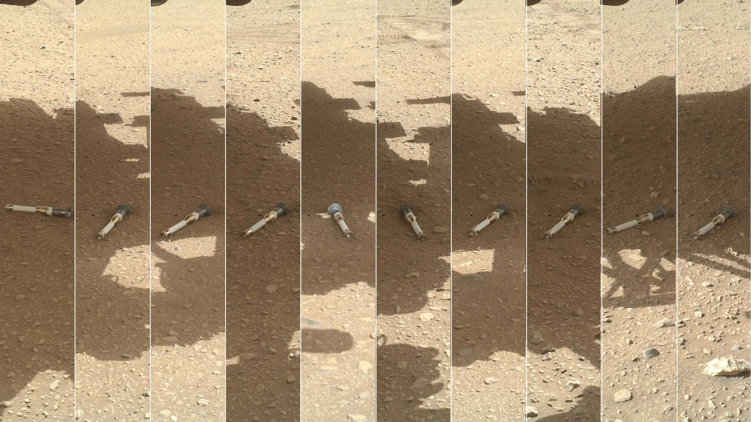
This photomontage shows each of the sample tubes shortly after they were deposited onto the surface by NASA’s Perseverance Mars rover, as viewed by the WATSON (Wide Angle Topographic Sensor for Operations and eNgineering) camera on the end of the rover’s 7-foot-long (2-meter-long) robotic arm. Shown, from left, are “Malay,” “Mageik,” “Crosswind Lake,” “Roubion,” “Coulettes,” “Montdenier,” “Bearwallow,” “Skyland,” “Atsah,” and “Amalik.” Deposited from Dec. 21, 2022, to Jan. 28, 2023, these samples make up the sample depot Perseverance built at “Three Forks,” a location within Mars’ Jezero Crater.
This photomontage shows tubes containing samples from Mars, as collected by NASA’s Perseverance Mars rover.  The agency’s Mars Sample Return Program plans to bring these samples back to study them in state-of-the-art facilities on Earth.
Credit: NASA/JPL-Caltech/MSSS

To maximize chances of successfully bringing the first Martian rock and sediment samples to Earth for the benefit of humanity, NASA announced Tuesday a new approach to its Mars Sample Return Program. The agency will simultaneously pursue two landing architectures, or strategic plans, during formulation, encouraging competition and innovation, as well as cost and schedule savings.

NASA plans to later select a single path forward for the program, which aims to better understand the mysteries of the universe, and to help determine whether the Red Planet ever hosted life. NASA is expected to confirm the program – and its design – in the second half of 2026.

“Pursuing two potential paths forward will ensure that NASA is able to bring these samples back from Mars with significant cost and schedule saving compared to the previous plan,” said NASA Administrator Bill Nelson. “These samples have the potential to change the way we understand Mars, our universe, and – ultimately – ourselves. I’d like to thank the team at NASA and the strategic review team, led by Dr. Maria Zuber, for their work.”

In September 2024, the agency accepted 11 studies from the NASA community and industry on how best to return Martian samples to Earth. A Mars Sample Return Strategic Review team was charged with assessing the studies and then recommending a primary architecture for the campaign, including associated cost and schedule estimates.

“NASA’s rovers are enduring Mars’ harsh environment to collect ground-breaking science samples,” said Nicky Fox, who leads NASA’s Science Mission Directorate. “We want to bring those back as quickly as possible to study them in state-of-the-art facilities. Mars Sample Return will allow scientists to understand the planet’s geological history and the evolution of climate on this barren planet where life may have existed in the past and shed light on the early solar system before life began here on Earth. This will also prepare us to safely send the first human explorers to Mars.”

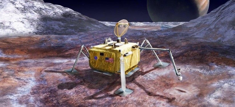
During formulation, NASA will proceed with exploring and evaluating two distinct means of landing the payload platform on Mars. The first option will leverage previously flown entry, descent, and landing system designs, namely the sky crane method, demonstrated with the Curiosity and Perseverance missions. The second option will capitalize on using new commercial capabilities to deliver the lander payload to the surface of Mars.

For both potential options, the mission’s landed platform will carry a smaller version of the Mars Ascent Vehicle. The platform’s solar panels will be replaced with a radioisotope power system that can provide power and heat through the dust storm season at Mars, allowing for reduced complexity.

The orbiting sample container will hold 30 of the sample tubes containing samples the Perseverance lander has been collecting from the surface of Mars. A redesign of the sample loading system on the lander, which will place the samples into the orbiting sample container, simplifies the backward planetary protection implementation by eliminating the accumulation of dust on the outside of the sample container.

Both mission options rely on a capture, containment and return system aboard ESA’s (European Space Agency’s) Earth Return Orbiter to capture the orbiting sample container in Mars orbit. ESA is evaluating NASA’s plan.

For more information on NASA’s exploration of Mars, visit:

https://www.nasa.gov/mars

-end-

Meira Bernstein / Dewayne Washington
Headquarters, Washington
202-358-1100
meira.b.bernstein@nasa.gov / dewayne.a.washington@nasa.gov

Share

Details

Last Updated

Jan 07, 2025

Powered by WPeMatico

Get The Details…
Roxana Bardan

AAS Hyperwall Schedule

AAS Hyperwall Schedule

3 min read

AAS Hyperwall Schedule

NASA Science at AAS Hyperwall Schedule, January 12-16, 2025

Join NASA in the Exhibit Hall (Booth #505) for Hyperwall Storytelling by NASA experts. Full Hyperwall Agenda below.

separater line

SUNDAY, JANUARY 12

7:00 – 7:15 PM    NASA Cosmic Pathfinders Program: Transforming the Early-Career Experience in STEM

Ronald Gamble
7:15 – 7:30 PM The Hubble Space Telescope: A New Era of Powerful Discovery

Jennifer Wiseman
7:30 – 7:45 PM     Unveiling High-Redshift Galaxies Using JWST-MIRI

Macarena Garcia
7:45 – 8:00 PM NASA’s Habitable Worlds Observatory

Megan Ansdell
8:00 – 8:15 PM Get Ready for the Nancy Grace Roman Space Telescope

Dominic Benford
8:15 – 8:30 PM TESS and the Extended Mission

Rebekah Hounsell

MONDAY, JANUARY 13

9:00 – 9:15 AM Effective Approaches to Making NASA Science Accessible to All

Tim Rhue
9:15 – 9:30 AM   
AXIS: The Next-Generation X-ray Imaging Probe Mission

Erin Kara
9:30 – 9:45 AM 25 Years of Science with the Chandra X-ray Observatory

Rudy Montez, Jr
9:45 – 10:00 AM Pandora SmallSat: Mission Update

Tom Greene
5:30 – 5:45 PM Two Years of Exoplanets with JWST

Knicole Colon
5:45 – 6:00 PM LISA Laser Interferometer Space Antenna

Ira Thorpe
6:00 – 6:15 PM Roman Coronagraph

Julien Girard
6:15 – 6:30 PM TBD

Olivier Dore

TUESDAY, JANUARY 14

9:00 – 9:15 AM 25 Years and Beyond with XMM-Newton

Kim Weaver
9:15 – 9:30 AM US Archival Science with Euclid

Shoubaneh Hemmati
9:30 – 9:45 AM            HWO & the Story of Life in the Universe

Giada Arney
9:45 – 10:00 AM NASA’s Office of the Chief Science Data Officer: Creating a Culture of Innovation and Collaboration

Steven Crawford
12:30 – 12:45 PM Jdaviz, the JWST Data Analysis and Visualization Tool

Camilla Pacifici
12:45 – 1:00 PM SPHEREx Instrument Integration and Pre-launch Calibration

Chi Nguyen
1:00 – 1:15 PM NASA-PEER: Maximizing the Post-bac Experience and Preparing the Next Generation for Grad School

NASA-PEER
1:15 – 1:30 PM Roman Galactic Plane Survey

Bob Benjamin
1:30 – 1:45 PM Roman Galactic Bulge Time Domain Survey

Jessie Christiansen
1:45 – 2:00 PM Galaxy Formation with SPHEREx

Jordan Mirocha
5:30 – 5:45 PM Roman Wide Field Instrument: From Ground Tests to Science

Jennie Paine
5:45 – 6:00 PM Extraordinary New Views of Nearby Galaxies with JWST

Janice Lee
6:00 – 6:15 PM A NICER View of Astrophysics and Exploration from the ISS

Elizabeth Ferrara
6:15 – 6:30 PM PRobe far-Infrared Mission for Astrophysics (PRIMA) Overview

Elisabeth (Betsy) Mills

WEDNESDAY, JANUARY 15

9:00 – 9:15 AM Machine Learning Adventures in Chandra’s X-Ray Universe

Victor Samuel Perez Diaz
9:15 – 9:30 AM You Were Here: The Visionary Scientific Goals of the Habitable Worlds Observatory

Jason Tumlinson
9:30 – 9:45 AM            JWST and Planetary Science

Stefanie Milam
9:45 – 10:00 AM Science Explorer: Accelerating the Discovery of NASA Science Alberto Accomazzi
12:30 – 12:45 PM What to expect for Galaxy Evolution with Roman: Lessons from JWST

Vihang Mehta
12:45 – 1:00 PM The Rocky Worlds DDT: exploring rocky exoplanet atmospheres with 500 JWST hours and 250 HST orbits

Hannah Diamond-Lowe
1:00 – 1:15 PM NASA’s Astrophoto Challenge: Engage the Public with Opportunities to Create their Own Images with NASA Data

Brandon Lawton
1:15 – 1:30 PM Roman Core Community Survey-High Latitude Time Domain Survey

Roman Speaker
1:30 – 1:45 PM Understanding the Sun’s Magnetic Cycle with COFFIES

Chris Lombardi
1:45 – 2:00 PM Our Dynamic Solar Neighborhood

Jackie Faherty
5:30 – 5:45 PM Astrophysics at NASA

Peter Kurczynski
5:45 – 6:00 PM NewAthena: Heading towards the next X-ray Flagship

Kristin Madsen
6:00 – 6:15 PM Pandora SmallSat: Mission Update

Lindsey Wiser
6:15 – 6:30 PM Cloud Science Platforms in the Era of Big Data

Thomas Dutkiewicz

THURSDAY, JANUARY 16

9:00 – 9:15 AM Looking at Exoplanets with the Chandra X-ray Observatory Scott Wolk
9:15 – 9:30 AM Educational Outreach with NASA Science Activation

Ana Aranda
9:30 – 9:45AM    SPHEREx In-Orbit Commission and Data Products

Howard Hui
9:45 – 10:00 AM Roman Core Community Survey- High Latitude Wide Area Survey

Roman Speaker
10:00 AM Livestream NICER repair

12:30 – 12:45 PM Overlapping Galaxy Pairs with Hubble and JWST

Benne Holwerda
12:45 – 1:00 PM Top 5 Chandra Discoveries

Rudy Montez, Jr
1:00 – 1:15 PM What is Webb Looking At Now?

Quyen Hart
1:15 – 1:30 PM Pandora SmallSat: Enabling Early Career Opportunities

Knicole Colon
1:30 – 1:45 PM Roman Coronagraph

Roman Speaker

Share

Details

Last Updated

Jan 07, 2025

Related Terms

Powered by WPeMatico

Get The Details…

NASA’s AI Use Cases: Advancing Space Exploration with Responsibility 

NASA’s AI Use Cases: Advancing Space Exploration with Responsibility 

NASA’s 2024 AI Use Case inventory highlights the agency’s commitment to integrating artificial intelligence in its space missions and operations. The agency’s updated inventory consists of active AI use cases, ranging from AI-driven autonomous space operations, such as navigation for the Perseverance Rover on Mars, to advanced data analysis for scientific discovery. 

AI Across NASA 

NASA’s use of AI is diverse and spans several key areas of its missions: 

Autonomous Exploration and Navigation 

  • AEGIS (Autonomous Exploration for Gathering Increased Science): AI-powered system designed to autonomously collect scientific data during planetary exploration. 
  • Enhanced AutoNav for Perseverance Rover: Utilizes advanced autonomous navigation for Mars exploration, enabling real-time decision-making. 
  • MLNav (Machine Learning Navigation): AI-driven navigation tools to enhance movement across challenging terrains. 
  • Perseverance Rover on Mars – Terrain Relative Navigation: AI technology supporting the rover’s navigation across Mars, improving accuracy in unfamiliar terrain. 

Mission Planning and Management 

  • ASPEN Mission Planner: AI-assisted tool that helps streamline space mission planning and scheduling, optimizing mission efficiency. 
  • AWARE (Autonomous Waiting Room Evaluation): AI system that manages operational delays, improving mission scheduling and resource allocation. 
  • CLASP (Coverage Planning & Scheduling): AI tools for resource allocation and scheduling, ensuring mission activities are executed seamlessly. 
  • Onboard Planner for Mars2020 Rover: AI system that helps the Perseverance Rover autonomously plan and schedule its tasks during its mission. 

Environmental Monitoring and Analysis 

  • SensorWeb for Environmental Monitoring: AI-powered system used to monitor environmental factors such as volcanoes, floods, and wildfires on Earth and beyond. 
  • Volcano SensorWeb: Similar to SensorWeb, but specifically focused on volcanic activity, leveraging AI to enhance monitoring efforts. 
  • Global, Seasonal Mars Frost Maps: AI-generated maps to study seasonal variations in Mars’ atmosphere and surface conditions. 

Data Management and Automation 

  • NASA OCIO STI Concept Tagging Service: AI tools that organize and tag NASA’s scientific data, making it easier to access and analyze. 
  • Purchase Card Management System (PCMS): AI-assisted system for streamlining NASA’s procurement processes and improving financial operations. 

Aerospace and Air Traffic Control 

  • NextGen Methods for Air Traffic Control: AI tools to optimize air traffic control systems, enhancing efficiency and reducing operational costs. 
  • NextGen Data Analytics: Letters of Agreement: AI-driven analysis of agreements within air traffic control systems, improving management and operational decision-making. 

Space Exploration 

  • Mars2020 Rover (Perseverance): AI systems embedded within the Perseverance Rover to support its mission to explore Mars. 
  • SPOC (Soil Property and Object Classification): AI-based classification system used to analyze soil and environmental features, particularly for Mars exploration. 

Ethical AI: NASA’s Responsible Approach 

NASA ensures that all AI applications adhere to Responsible AI (RAI) principles outlined by the White House in its Executive Order 13960. This includes ensuring AI systems are transparent, accountable, and ethical. The agency integrates these principles into every phase of development and deployment, ensuring AI technologies used in space exploration are both safe and effective. 

Looking Forward: AI’s Expanding Role 

As AI technologies evolve, NASA’s portfolio of AI use cases will continue to grow. With cutting-edge tools currently in development, the agency is poised to further integrate AI into more aspects of space exploration, from deep space missions to sustainable solutions for planetary exploration. 

By maintaining a strong commitment to both technological innovation and ethical responsibility, NASA is not only advancing space exploration but also setting an industry standard for the responsible use of artificial intelligence in scientific and space-related endeavors. 

Powered by WPeMatico

Get The Details…
Kate Halloran

2023 Entrepreneurs Challenge Winner Skyline Nav AI: Revolutionizing GPS-Independent Navigation with Computer Vision

2023 Entrepreneurs Challenge Winner Skyline Nav AI: Revolutionizing GPS-Independent Navigation with Computer Vision

3 min read

2023 Entrepreneurs Challenge Winner Skyline Nav AI: Revolutionizing GPS-Independent Navigation with Computer Vision

NASA sponsored Entrepreneurs Challenge events in 2020, 2021, and 2023 to identify innovative ideas and technologies from small business start-ups with the potential to advance the agency’s science goals. To help leverage external funding sources for the development of innovative technologies of interest to NASA, SMD involved the venture capital community in Entrepreneurs Challenge events. Challenge winners were awarded prize money, and in 2023 the total Entrepreneurs Challenge prize value was $1M. Numerous challenge winners have subsequently received funding from both NASA and external sources (e.g., other government agencies or the venture capital community) to further develop their technologies.

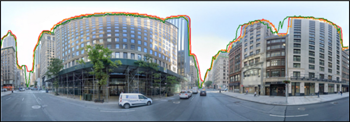
Skyline Nav AI, a winner of the 2023 NASA Entrepreneurs Challenge, is pioneering GPS-independent navigation by leveraging cutting-edge computer vision models, artificial intelligence (AI), and edge computing.

Skyline Nav AI’s flagship technology offers precise, real-time geolocation without the need for GPS, Wi-Fi, or cellular networks. The system utilizes machine learning algorithms to analyze terrain and skyline features and match them with preloaded reference datasets, providing up to centimeter-level accuracy in GPS-denied environments. This capability could enable operations in areas where GPS signals are absent, blocked, degraded, spoofed, or jammed, including urban canyons, mountainous regions, and the Moon.

City roads with three tall buildings. The building tops are outlined with three lines—one red, one green, and one orange.
Skyline Nav AI’s flagship technology at work in New York to provide precise location by matching the detected skyline with a reference data set. The red line shows detection by Skyline Nav AI technology, the green line marks the true location in the reference satellite dataset, and the orange line represents the matched location (i.e., the location extracted from the satellite dataset using Skyline Nav AI algorithms).

Skyline Nav’s visual navigation technology can deliver accuracy up to five meters, 95% of the time. The AI-powered visual positioning models continuously improve geolocation precision through pixel-level analysis and semantic segmentation of real-time images, offering high reliability without the need for GPS.

In addition to its visual-based AI, Skyline Nav AI’s software is optimized for edge computing, ensuring that all processing occurs locally on the user’s device. This design enables low-latency, real-time decision-making without constant satellite or cloud-based connectivity, making it ideal for disconnected environments such as combat zones or space missions.

Furthermore, Skyline Nav AI’s technology can be integrated with various sensors, including inertial measurement units (IMUs), lidar, and radar, to further enhance positioning accuracy. The combination of visual navigation and sensor fusion can enable centimeter-level accuracy, making the technology potentially useful for autonomous vehicles, drones, and robotics operating in environments where GPS is unreliable.

“Skyline Nav AI aims to provide the world with an accurate, resilient alternative to GPS,” says Kanwar Singh, CEO of Skyline Nav AI. “Our technology empowers users to navigate confidently in even the most challenging environments, and our recent recognition by NASA and other partners demonstrates the value of our innovative approach to autonomous navigation.”

Skyline Nav AI continues to expand its influence through partnerships with organizations such as NASA, the U.S. Department of Defense, and the commercial market. Recent collaborations include projects with MIT, Draper Labs, and AFRL (Air Force Research Laboratory), as well as winning the MOVE America 2024 Pitch competition and being a finalist in SXSW 2024.

Sponsoring Organization: The NASA Science Mission Directorate sponsored the Entrepreneurs Challenge events.

Project Leads: Kanwar Singh, Founder & CEO of Skyline Nav AI

Share

Details

Last Updated

Jan 07, 2025

Powered by WPeMatico

Get The Details…

NASA Kicks off Testing Campaign for Remotely Piloted Cargo Flights

NASA Kicks off Testing Campaign for Remotely Piloted Cargo Flights

4 min read

Preparations for Next Moonwalk Simulations Underway (and Underwater)

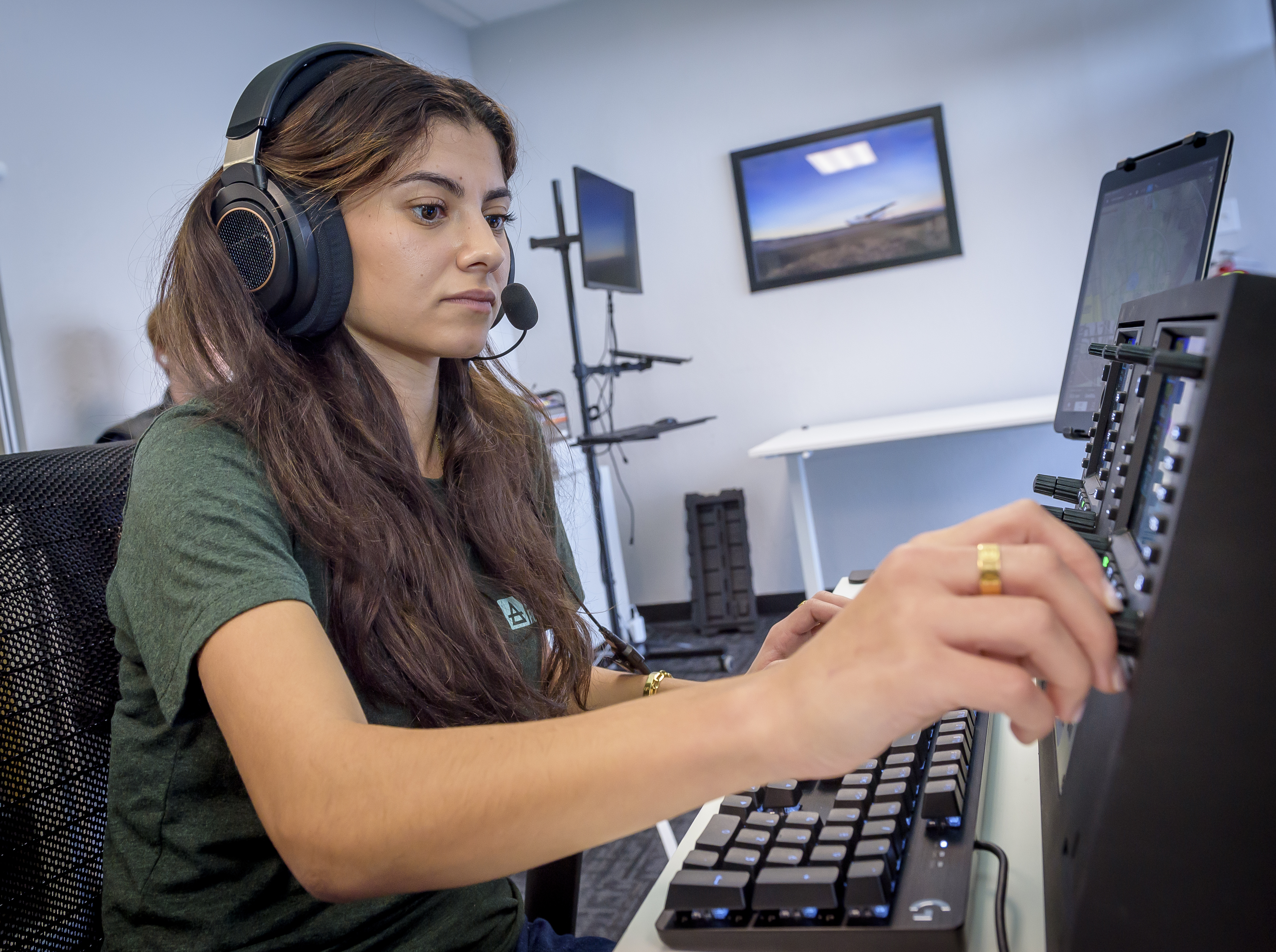
Danah Tommalieh, commercial pilot and engineer at Reliable Robotics, inputs a flight plan at the control center in Mountain View, California, ahead of remotely operating a Cessna 208 aircraft at Hollister municipal airport in Hollister, California.
NASA/Don Richey

NASA recently began a series of flight tests with partners to answer an important aviation question: What will it take to integrate remotely piloted or autonomous planes carrying large packages and cargo safely into the U.S. airspace? Researchers tested new technologies in Hollister, California, that are helping to investigate what tools and capabilities are needed to make these kinds of flights routine.  

The commercial industry continues to make advancements in autonomous aircraft systems aimed at making it possible for remotely operated aircraft to fly over communities – transforming the way we will transport people and goods. As the Federal Aviation Administration (FAA) develops standards for this new type of air transportation, NASA is working to ensure these uncrewed flights are safe by creating the required technological tools and infrastructure. These solutions could be scaled to support many different remotely piloted aircraft – including air taxis and package delivery drones – in a shared airspace with traditional crewed aircraft. 

“Remotely piloted aircraft systems could eventually deliver cargo and people to rural areas with limited access to commercial transportation and delivery services,” said Shivanjli Sharma, aerospace engineer at NASA’s Ames Research Center in California’s Silicon Valley. “We’re aiming to create a healthy ecosystem of many different kinds of remotely piloted operations. They will fly in a shared airspace to provide communities with better access to goods and services, like medical supply deliveries and more efficient transportation.”  

During a flight test in November, Reliable Robotics, a company developing an autonomous flight system, remotely flew its Cessna 208 Caravan aircraft through pre-approved flight paths in Hollister, California. 

Although a safety pilot was aboard, a Reliable Robotics remote pilot directed the flight from their control center in Mountain View, more than 50 miles away.

A close up image of a cockpit of a Cessna 208, showing various controls and mechanics.
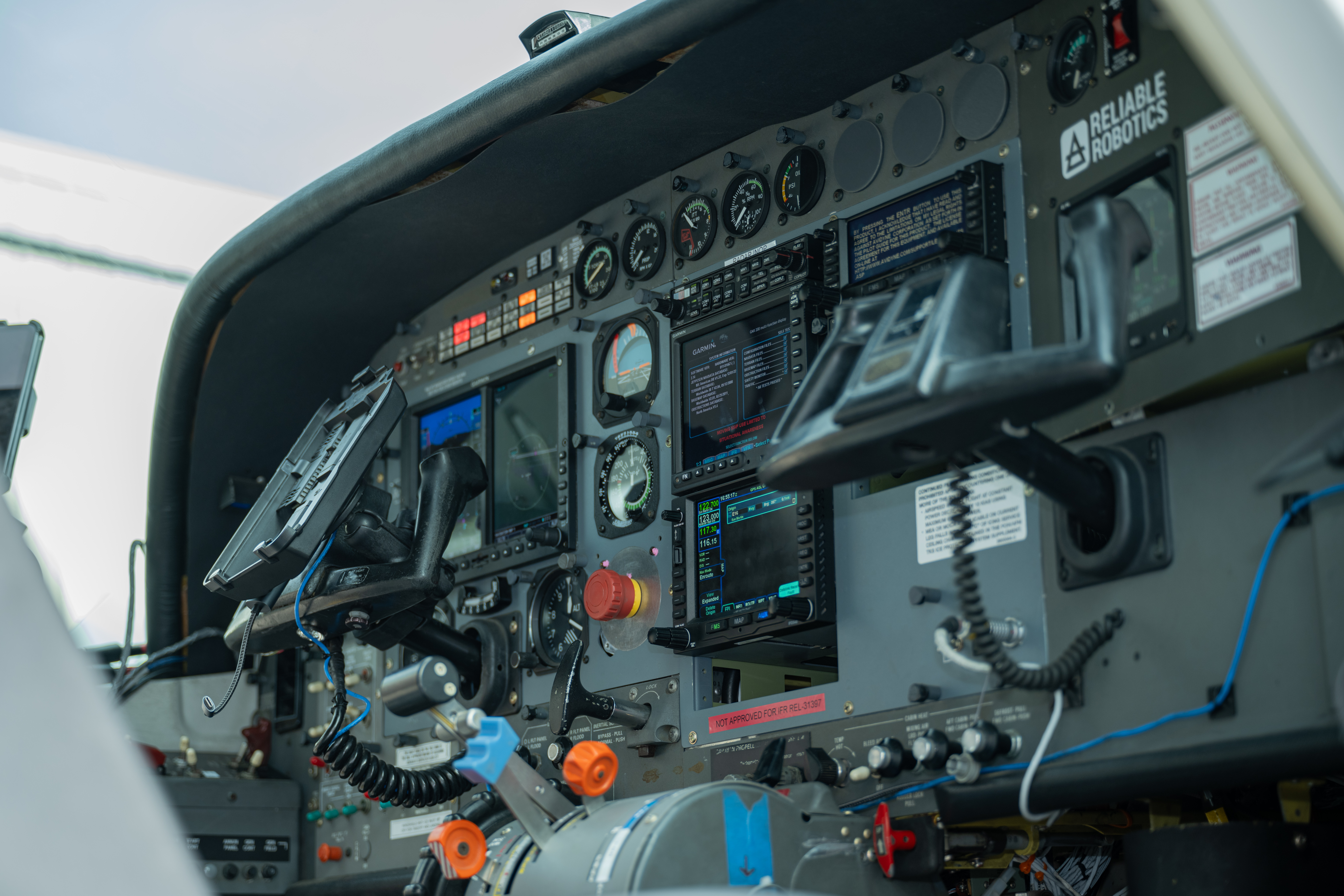
Cockpit of Reliable Robotics’ Cessna 208 aircraft outfitted with autonomous technology for remotely-piloted operations.
NASA/Brandon Torres Navarrete

Congressional staffers from the United States House and Senate’s California delegation joined NASA Deputy Associate Administrator for Aeronautics Research Mission Directorate, Carol Caroll, Ames Aeronautics Director, Huy Tran, and other Ames leadership at Reliable Robotics Headquarters to view the live remote flight.

Researchers evaluated a Collins Aerospace ground-based surveillance system’s ability to detect nearby air traffic and provide the remote pilot with information in order to stay safely separated from other aircraft in the future. 

Initial analysis shows the ground-based radar actively surveilled the airspace during the aircraft’s taxi, takeoff, and landing. The data was transmitted from the radar system to the remote pilot at Reliable Robotics. In the future, this capability could help ensure aircraft remain safely separated across all phases of fight.   

A Cessna 208 aircraft with propeller, white paint with black accents is shown flying against a mostly clear blue sky. In the background, wispy clouds and a distant hill are visible.
A Reliable Robotics’ modified Cessna 208 aircraft flies near Hollister Airport. A Reliable Robotics pilot operated the aircraft remotely from the control center in Mountain View.
NASA/Brandon Torres Naverrete

While current FAA operating rules require pilots to physically see and avoid other aircraft from inside the cockpit, routine remotely piloted aircraft will require a suite of integrated technologies to avoid hazards and coordinate with other aircraft in the airspace.  

A radar system for ground-based surveillance offers one method for detecting other traffic in the airspace and at the airport, providing one part of the capability to ensure pilots can avoid collision and accomplish their desired missions. Data analysis from this testing will help researchers understand if ground-based surveillance radar can be used to satisfy FAA safety rules for remotely piloted flights. 

NASA will provide analysis and reports of this flight test to the FAA and standards bodies. 

“This is an exciting time for the remotely piloted aviation community,” Sharma said. “Among other benefits, remote operations could provide better access to healthcare, bolster natural disaster response efforts, and offer more sustainable and effective transportation to both rural and urban communities. We’re thrilled to provide valuable data to the industry and the FAA to help make remote operations a reality in the near future.”  

Over the next year, NASA will work with additional aviation partners on test flights and simulations to test weather services, communications systems, and other autonomous capabilities for remotely piloted flights. NASA researchers will analyze data from these tests to provide a comprehensive report to the FAA and the community on what minimum technologies and capabilities are needed to enable and scale remotely piloted operations. 

This flight test data analysis is led out of NASA Ames under the agency’s Air Traffic Management Exploration project. This effort supports the agency’s Advanced Air Mobility mission research, ensuring the United States stays at the forefront of aviation innovation. 

Powered by WPeMatico

Get The Details…
Hillary Smith