Going Home: NASA Retires S-3B Viking to POW/MIA Museum

Going Home: NASA Retires S-3B Viking to POW/MIA Museum

The S-3B Viking aircraft rests in the NASA Glenn Hangar. The plane is painted gray, black, and white. The wings are folded atop the aircraft.
This S-3 supported vital flight research by donating parts to its sister plane, another S3-B Viking that was retired in 2021.
Credit: NASA/Jordan Cochran

After supporting the center’s research missions for more than a decade, NASA’s S-3B Viking aircraft is moving on from NASA’s Glenn Research Center in Cleveland to begin a new and honorable assignment.

The aircraft is heading to the National POW/MIA Memorial and Museum in Jacksonville, Florida, where it will be on display, honoring all Prisoners of War (POW), those Missing in Action (MIA), and the families who seek the return of their loved ones. The museum gives visitors a place of solace to reflect, learn, and hear stories about America’s POW and MIA service members through exhibits and events.

A team of volunteers, many of whom are veterans, converged to disassemble an S-3B Viking at NASA’s Glenn Research Center in Cleveland so it could be transported by truck to the National Pow/MIA Memorial and Museum in Jacksonville, Florida.
Credit: NASA/Lillianne Hammel

“We are honored to be part of it,” said JD Demers, chief of Aircraft Operations at NASA Glenn. “Moving the S-3 is a win-win for everybody. The museum gets an aircraft in beautiful shape, and our S-3 gets to continue living a meaningful life.”

Originally designed by Lockheed Martin as an anti-submarine warfare aircraft, NASA’s S-3B Viking will travel south to its new museum home, which is located at the former Naval Air Station Cecil Field where S-3B Vikings once flew. It will be displayed with a plaque recognizing the 54 service members who perished during S-3 flight missions. 

Two men pose smiling in front of an S-3B Viking aircraft inside NASA Glenn’s Hangar. They both wear blue shirts and khaki pants. The man on the left has his hands on his hips, and the man on the right stands with his arms at his sides. Behind them is a plane painted gray, black, and white with its wings folded atop of the aircraft.
NASA’s JD Demers poses with National POW/MIA Memorial and Museum’s Ed Turner in front of NASA’s S-3B Viking aircraft.
Credit: NASA/Jordan Cochran  

“It’s really fortunate for us that this S-3 has such a well-kept, beautiful airframe that we can use as part of this plaza,” said Ed Turner, executive director of the National POW/MIA Memorial and Museum. “Cecil Field was the East Coast home for the S-3B Vikings, so we are proud to have it for display here as one of Cecil’s legacy aircraft.”

Behind the scenes, this S-3 supported vital NASA flight research by donating parts to its sister plane, another S3-B Viking that was retired in 2021. Through the donation of its parts, the S-3 contributed to communications research in advanced air mobility and monitoring of algal bloom growth in Lake Erie.

“Having this aircraft added an extra 10 years of life to its sister plane,” Demers said. “Those 10 years were vital for research. This plane allowed us to keep flying that aircraft after the Navy retired the S-3B Vikings in 2009. We wouldn’t have been able to find parts.”

A man washes the S-3B Viking’s wings with a hose. He stands on a yellow ladder to reach the top of the aircraft’s wing. He wears sunglasses and a red hat. It is a sunny day, and sunlight reflects off the water from the hose. The aircraft is parked in front of the NASA Glenn Hangar. The wings are folded atop the aircraft.
NASA prepares its S-3B Viking for its journey to the National POW/MIA Memorial and Museum in Jacksonville, Florida.
Credit: NASA/Sara Lowthian-Hanna  

The U.S. Navy flew S-3 Vikings primarily out of three locations: North Island Naval Air Station, Naval Air Station Cecil Field, and Naval Air Station Jacksonville. There were S-3B Vikings in all locations except Jacksonville, until now.

“There are three bases in three locations that used to fly S-3s, and now each area has an S-3 as part of its display,” Demers said. “It belongs there. It’s going back to its original home.”

Powered by WPeMatico

Get The Details…
Kelly M. Matter

Sols 4511-4512: Low energy after a big weekend?

Sols 4511-4512: Low energy after a big weekend?

2 min read

Sols 4511-4512: Low energy after a big weekend?

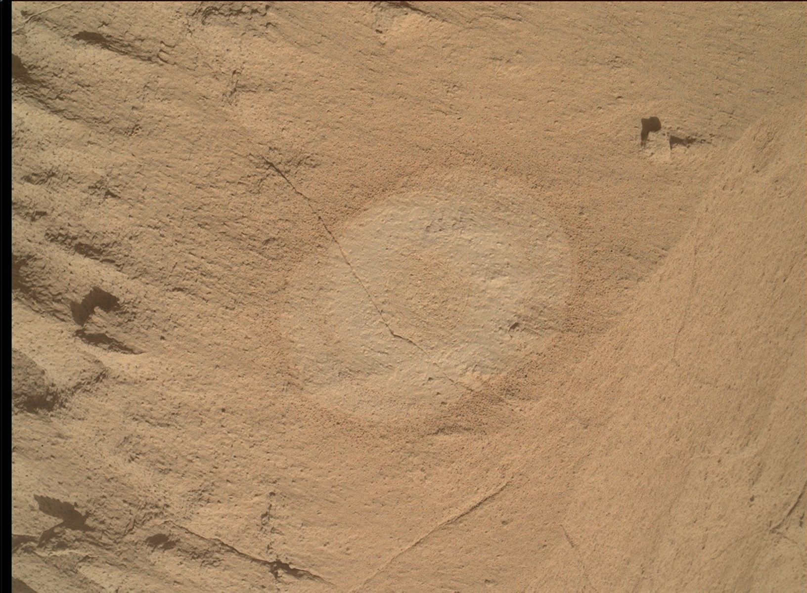
A grayscale photograph of the Martian surface from the Curiosity rover
This image was taken by Left Navigation Camera onboard NASA’s Mars rover Curiosity on Sol 4510 (2025-04-14 03:43:40 UTC).
NASA/JPL-Caltech

Written by Lauren Edgar, Planetary Geologist at USGS Astrogeology Science Center

Earth planning date: Monday, April 14, 2025

We all know the feeling: it’s Monday morning after a big weekend and you’re coming into the week wishing you’d had a little more time to rest and recharge.  Well, Curiosity probably feels the same way today. Curiosity accomplished a lot over the weekend, including full contact science, a MAHLI stereo imaging test, testing the collection of ChemCam passive spectral data at the same time as data transmission with one of the orbiters, and some APXS and MAHLI calibration target activities, plus a long 57 m drive. It was great to see all of those activities in the plan and to see some great drive progress. But that means we’re a bit tight on power for today’s plan!

I was on shift as Long Term Planner today, and the team had to think carefully about science priorities to fit within our power limit for today’s plan, and how that will prepare us for the rest of the week.  The team still managed to squeeze a lot of activities into today’s 2-sol plan. First, Curiosity will acquire Mastcam mosaics to investigate local stratigraphic relationships and diagenetic features. Then we’ll acquire some imaging to document the sandy troughs between bedrock blocks to monitor active surface processes. We’ll also take a Navcam mosaic to assess atmospheric dust. The science block includes a ChemCam LIBS observation on the bedrock target “Santa Margarita” and a long distance RMI mosaic of “Ghost Mountain” to look for possible boxwork structures. Then Curiosity will use the DRT, APXS and MAHLI to investigate the finely-laminated bedrock in our workspace at a target named “The Grotto.”  We’ll also collect APXS and MAHLI data on a large nodule in the workspace named “Torrey Pines” (meanwhile the Torrey Pines here on Earth was shaking in today’s southern California earthquakes! All is well but it gave some of our team members an extra jolt of adrenaline right before the SOWG meeting).  The second sol is focused on continuing our drive to the south and taking post-drive imaging to prepare for Wednesday’s plan.

Phew! Good job Curiosity, you made it through Monday.

Powered by WPeMatico

Get The Details…

Sols 4509-4510: A weekend of long drives

Sols 4509-4510: A weekend of long drives

3 min read

Sols 4509-4510: A weekend of long drives

A grayscale photograph of the Martian surface from the Curiosity rover
This image was taken by Left Navigation Camera onboard NASA’s Mars rover Curiosity on Sol 4507 (2025-04-11 03:54:35 UTC).

Written by Abigail Fraeman, Planetary Geologist at NASA’s Jet Propulsion Laboratory

Earth planning date: Friday, April 11, 2025

Curiosity is continuing to book it to the potential boxwork structures.  The rover drove over 50 meters on Wednesday, and we plan to drive more than 50 meters again in today’s plan thanks to an unusually good viewshed that allows us to see far ahead.  We’ve been able to see glimpses of the boxwork structures in the distance for a few weeks now, and I am really excited about being able to plan long drives that get us closer and closer. What will we find when we reach them?

Power was on everyone’s mind as we put the plan together today. The science team had lots of amazing ideas about observations to collect from our current location, but we had to carefully plan and prioritize them to make sure we didn’t use too much power and leave the rover battery lower than we’d like for Monday’s plan.  Winter on Mars certainly keeps us on our toes!  We ended up putting together what I think is a pretty good set of activities for the weekend.  MAHLI, APXS, and ChemCam will all work together to observe a flat rock in front of us named “Iron Mountain.” MAHLI will also do an experiment with this rock, testing different combinations of camera positions to see which produces the best data to help us generate 3D models of the rock’s surface.  I know rocks don’t have feelings, but if they did, I hope Iron Mountain can use this time to feel a bit like a movie star on the red carpet, getting photographed from all angles. Mastcam will also be photographing the surroundings, working with ChemCam’s RMI imager to take images the ridge containing boxwork structures named “Ghost Mountain,” and taking some solo shots of targets in the foreground named “Redondo Flat,” “Silverwood Sanctuary,” and the oft photographed Gould Mesa.  Navcam, REMS, and DAN round out the science plan with some environmental observations. We’ll be getting one more science and engineering hybrid observation when we collect ChemCam passive spectral data of the instrument’s calibration target in parallel with one of our communication passes.  This observation is part of a series of tests we’re doing to run rover activities in parallel with these passes, and if successful, will allow us to be more even more power efficient in the future.

We’re also celebrating a soliday this weekend, which means we only have a two-sol plan instead of our usual three as the Mars and Earth time zones re-align for the next few weeks.  I’m looking forward to seeing where Curiosity drives next week.

Powered by WPeMatico

Get The Details…

NASA Aims to Fly First Quantum Sensor for Gravity Measurements

NASA Aims to Fly First Quantum Sensor for Gravity Measurements

Researchers from NASA’s Jet Propulsion Laboratory in Southern California, private companies, and academic institutions are developing the first space-based quantum sensor for measuring gravity. Supported by NASA’s Earth Science Technology Office (ESTO), this mission will mark a first for quantum sensing and will pave the way for groundbreaking observations of everything from petroleum reserves to global supplies of fresh water.

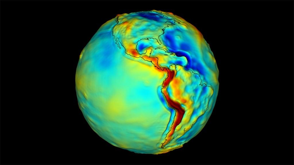
 Map of Earth's gravity with North and South America visible. The colors on the map vary and are yellow, green, blue, and red. Red indicates areas of greater gravitational pull and blue, less. South Central American through the western coast of South America are red, the Atlantic ocean is mostly blue and the Pacific ocean varies from yellow to teal.
A map of Earth’s gravity. Red indicates areas of the world that exert greater gravitational pull, while blue indicates areas that exert less. A science-grade quantum gravity gradiometer could one day make maps like this with unprecedented accuracy.
Image Credit: NASA

Earth’s gravitational field is dynamic, changing each day as geologic processes redistribute mass across our planet’s surface. The greater the mass, the greater the gravity.

You wouldn’t notice these subtle changes in gravity as you go about your day, but with sensitive tools called gravity gradiometers, scientists can map the nuances of Earth’s gravitational field and correlate them to subterranean features like aquifers and mineral deposits. These gravity maps are essential for navigation, resource management, and national security.

“We could determine the mass of the Himalayas using atoms,” said Jason Hyon, chief technologist for Earth Science at JPL and director of JPL’s Quantum Space Innovation Center. Hyon and colleagues laid out the concepts behind their Quantum Gravity Gradiometer Pathfinder (QGGPf) instrument in a recent paper in EPJ Quantum Technology.

Gravity gradiometers track how fast an object in one location falls compared to an object falling just a short distance away. The difference in acceleration between these two free-falling objects, also known as test masses, corresponds to differences in gravitational strength. Test masses fall faster where gravity is stronger.

QGGPf will use two clouds of ultra-cold rubidium atoms as test masses. Cooled to a temperature near absolute zero, the particles in these clouds behave like waves. The quantum gravity gradiometer will measure the difference in acceleration between these matter waves to locate gravitational anomalies.

Using clouds of ultra-cold atoms as test masses is ideal for ensuring that space-based gravity measurements remain accurate over long periods of time, explained Sheng-wey Chiow, an experimental physicist at JPL. “With atoms, I can guarantee that every measurement will be the same. We are less sensitive to environmental effects.”

Using atoms as test masses also makes it possible to measure gravity with a compact instrument aboard a single spacecraft. QGGPf will be around 0.3 cubic yards (0.25 cubic meters) in volume and weigh only about 275 pounds (125 kilograms), smaller and lighter than traditional space-based gravity instruments.

Quantum sensors also have the potential for increased sensitivity. By some estimates, a science-grade quantum gravity gradiometer instrument could be as much as ten times more sensitive at measuring gravity than classical sensors.

The main purpose of this technology validation mission, scheduled to launch near the end of the decade, will be to test a collection of novel technologies for manipulating interactions between light and matter at the atomic scale.

“No one has tried to fly one of these instruments yet,” said Ben Stray, a postdoctoral researcher at JPL. “We need to fly it so that we can figure out how well it will operate, and that will allow us to not only advance the quantum gravity gradiometer, but also quantum technology in general.”

This technology development project involves significant collaborations between NASA and small businesses. The team at JPL is working with AOSense and Infleqtion to advance the sensor head technology, while NASA’s Goddard Space Flight Center in Greenbelt, Maryland is working with Vector Atomic to advance the laser optical system.

Ultimately, the innovations achieved during this pathfinder mission could enhance our ability to study Earth, and our ability to understand distant planets and the role gravity plays in shaping the cosmos. “The QGGPf instrument will lead to planetary science applications and fundamental physics applications,” said Hyon.

To learn more about ESTO visit: https://esto.nasa.gov

Share

Details

Last Updated
Apr 15, 2025
Editor
NASA Science Editorial Team
Contact
Gage Taylor

Powered by WPeMatico

Get The Details…