NASA’s Hubble Identifies One of Darkest Known Galaxies
3 min read
NASA’s Hubble Identifies One of Darkest Known Galaxies
In the vast tapestry of the universe, most galaxies shine brightly across cosmic time and space. Yet a rare class of galaxies remains nearly invisible — low-surface-brightness galaxies dominated by dark matter and containing only a sparse scattering of faint stars.
One such elusive object, dubbed CDG-2, may be among the most heavily dark matter-dominated galaxies ever discovered. (Dark matter is an invisible form of matter that does not reflect, emit, or absorb light.) The science paper detailing this finding was published in The Astrophysical Journal Letters.
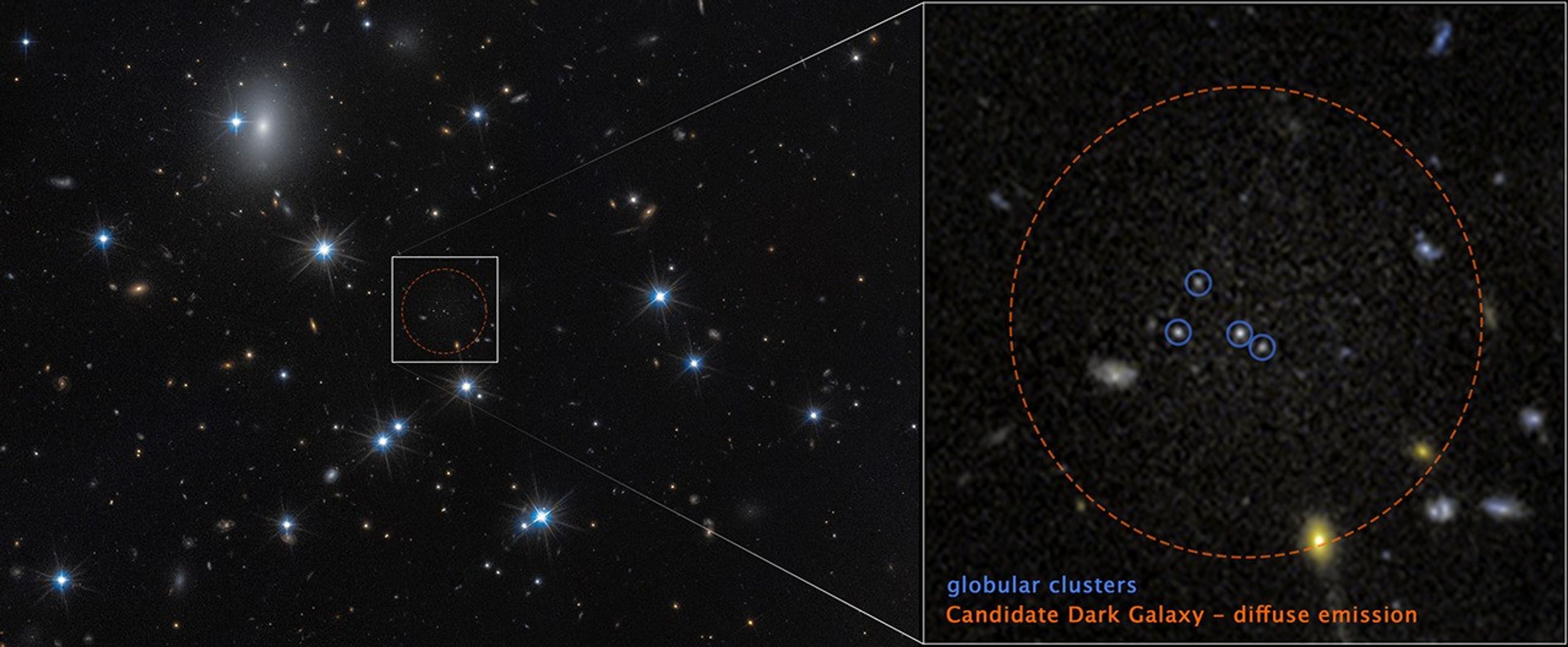
Detecting such faint galaxies is extraordinarily difficult. Using advanced statistical techniques, David Li of the University of Toronto, Canada, and his team identified 10 previously confirmed low-surface-brightness galaxies and two additional dark galaxy candidates by searching for tight groupings of globular clusters — compact, spherical star groups typically found orbiting normal galaxies. These clusters can signal the presence of a faint, hidden stellar population.
To confirm one of the dark galaxy candidates, astronomers employed a trio of observatories: NASA’s Hubble Space Telescope, ESA’s (European Space Agency) Euclid space observatory, and the ground-based Subaru Telescope in Hawaii. Hubble’s high-resolution imaging revealed a close collection of four globular clusters in the Perseus galaxy cluster, 300 million light-years away. Follow-up studies using Hubble, Euclid, and Subaru data then revealed a faint, diffuse glow surrounding the star clusters — strong evidence of an underlying galaxy.
“This is the first galaxy detected solely through its globular cluster population,” said Li. “Under conservative assumptions, the four clusters represent the entire globular cluster population of CDG-2.”
Preliminary analysis suggests CDG-2 has the luminosity of roughly 6 million Sun-like stars, with the globular clusters accounting for 16% of its visible content. Remarkably, 99% of its mass, which includes both visible matter and dark matter, appears to be dark matter. Much of its normal matter to enable star formation — primarily hydrogen gas — was likely stripped away by gravitational interactions with other galaxies inside the Perseus cluster.
Globular clusters possess immense stellar density and are gravitationally tightly bound. This makes the clusters more resistant to gravitational tidal disruption, and therefore reliable tracers of such ghostly galaxies.
As sky surveys expand with missions like Euclid, NASA’s upcoming Nancy Grace Roman Space Telescope, and the Vera C. Rubin Observatory, astronomers are increasingly turning to machine learning and statistical methods to sift through vast datasets.
The Hubble Space Telescope has been operating for more than three decades and continues to make ground-breaking discoveries that shape our fundamental understanding of the universe. Hubble is a project of international cooperation between NASA and ESA (European Space Agency). NASA’s Goddard Space Flight Center in Greenbelt, Maryland, manages the telescope and mission operations. Lockheed Martin Space, based in Denver, also supports mission operations at Goddard. The Space Telescope Science Institute in Baltimore, which is operated by the Association of Universities for Research in Astronomy, conducts Hubble science operations for NASA.
Related Images & Videos
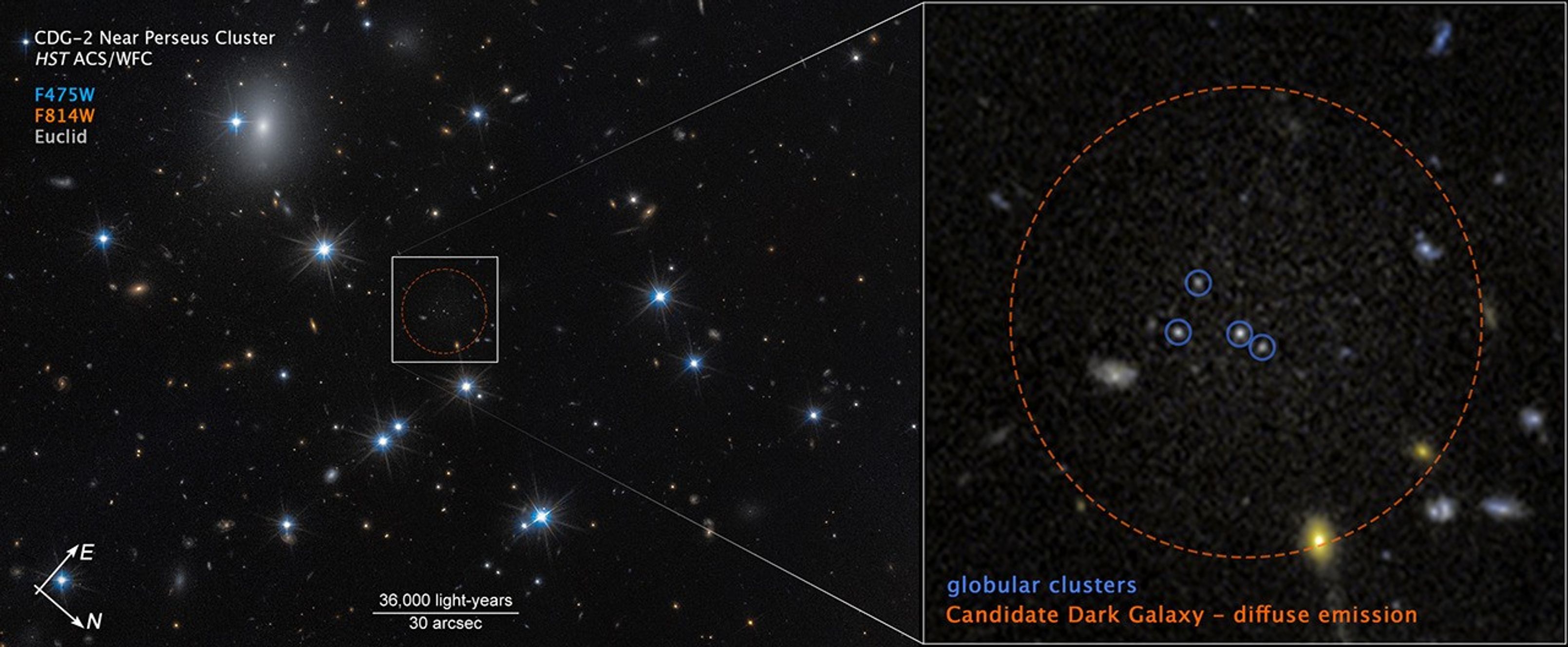
Dark Galaxy Near Perseus Cluster (Compass Image)
This image of dark galaxy CDG-2 was captured by the Hubble Space Telescope’s ACS (Advanced Camera for Surveys) with additional data from the European Space Agency’s Euclid space mission. The image shows a scale bar, compass arrows, and color key for reference.

Share
Details
Claire Andreoli
NASA’s Goddard Space Flight Center
Greenbelt, Maryland
claire.andreoli@nasa.gov
Christine Pulliam
Space Telescope Science Institute
Baltimore, Maryland
Related Terms
Related Links and Documents


Powered by WPeMatico