Northern Glow Spans Iceland and Canada

Northern Glow Spans Iceland and Canada

A nighttime satellite image shows a grayscale view of the northern lights over the Denmark Strait. Wisps of light stretch from Greenland to Iceland, with the brightest light just west of Iceland. Reykjavík city lights appear as a small dot.
February 16, 2026

Although the aurora borealis, or northern lights, is most often observed in March and September, it can appear at other times of the year if conditions are right. For instance, in February 2026, a minor geomagnetic storm produced a striking display of light swirling across northern skies.

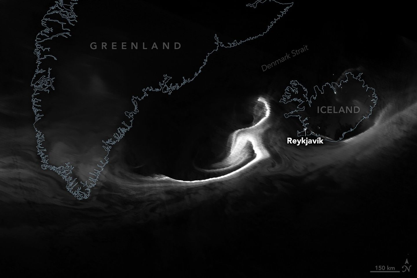
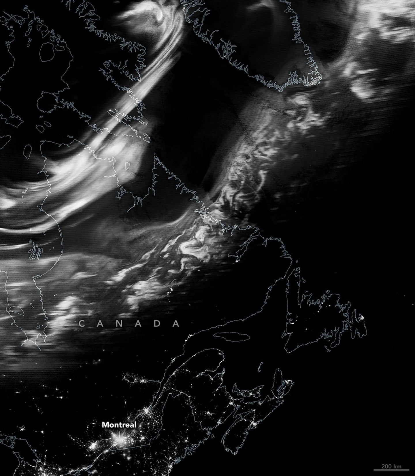
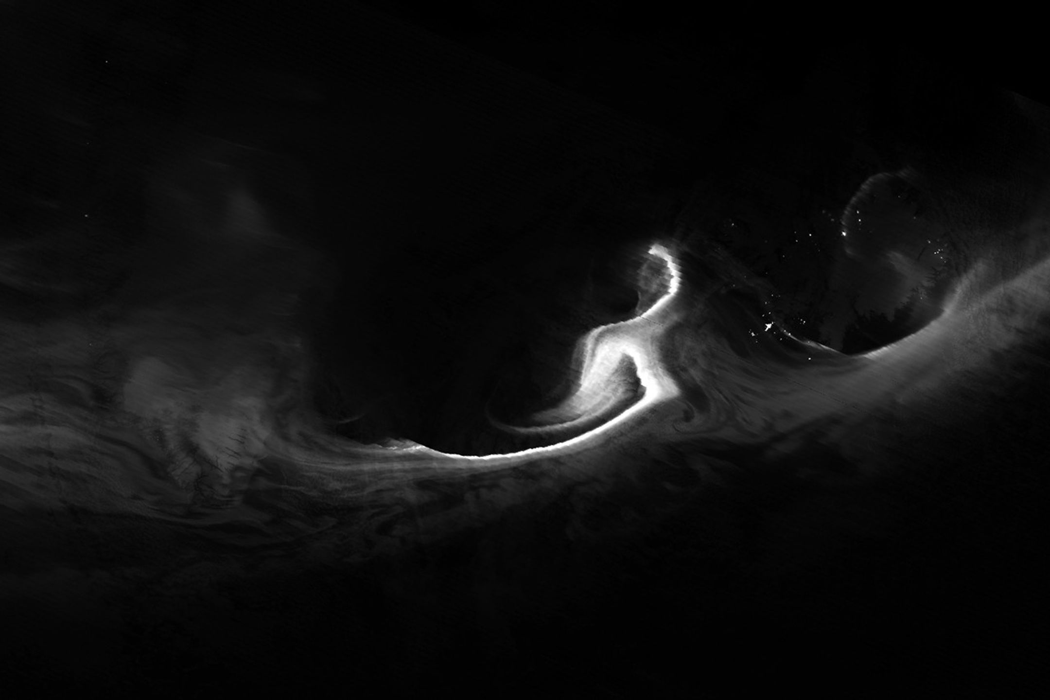
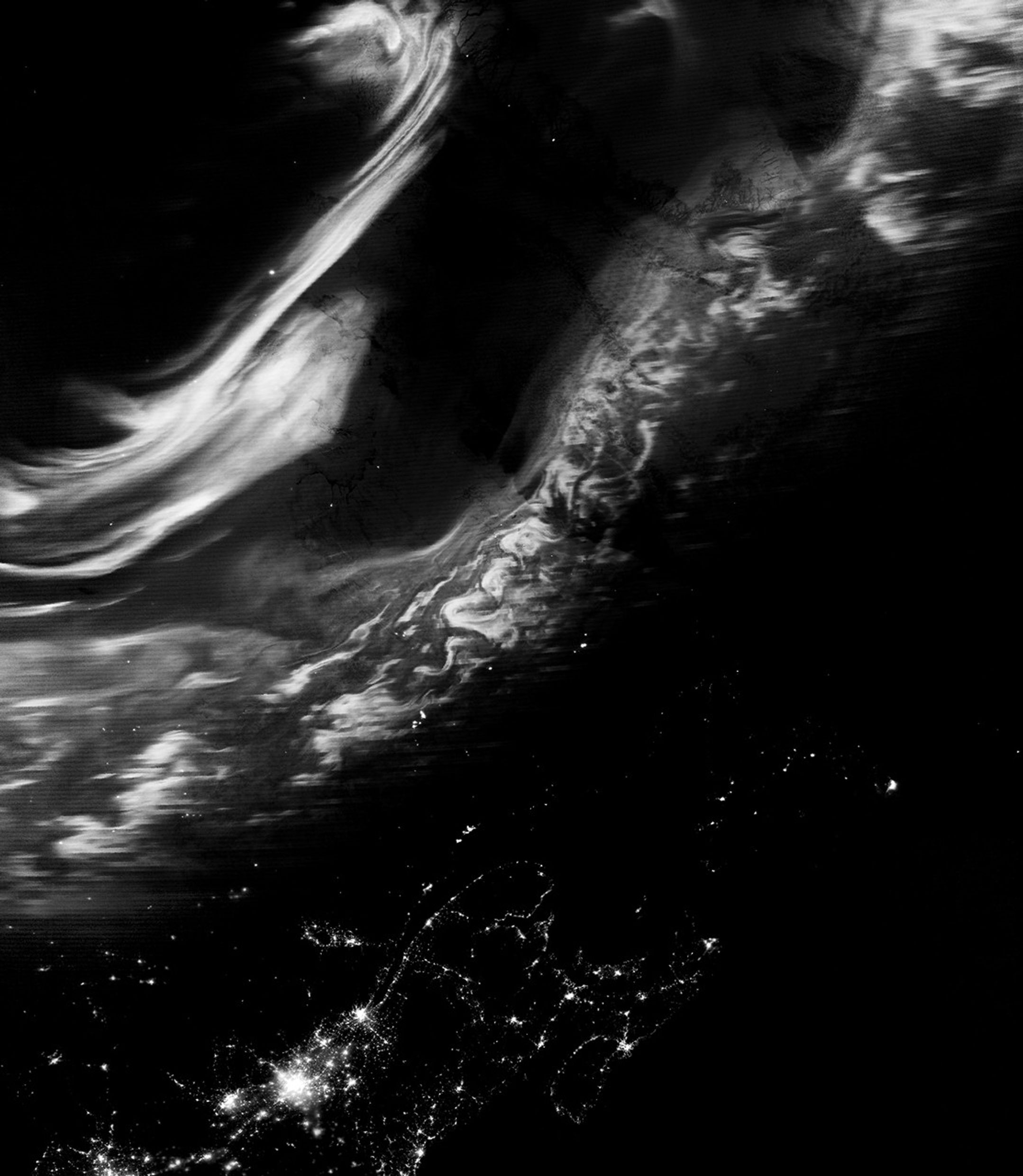
The VIIRS (Visible Infrared Imaging Radiometer Suite) on the Suomi NPP satellite acquired these images in the early morning hours of February 16. The VIIRS day-night band detects nighttime light in a range of wavelengths from green to near-infrared and uses filtering techniques to observe signals such as city lights, reflected moonlight, and auroras. While these satellite data are displayed in grayscale, auroras appear in various colors to observers on the ground, from green (the most common) to purple to red.

The first image (top) shows ribbons of light that shimmered over the Denmark Strait and Iceland at 04:45 Universal Time (4:45 a.m. local time in Reykjavík). The second image shows the view farther west, where the lights danced above the Canadian provinces of Québec and Newfoundland and Labrador at about 06:30 Universal Time (1:30 a.m. local time in Montreal).

A nighttime satellite image shows a grayscale view of the northern lights stretching from eastern Canada to southern Greenland. Urban light from Montreal and nearby cities appear across the bottom of the scene.
February 16, 2026

According to the NOAA Space Weather Prediction Center, a minor geomagnetic storm was in progress during this period. Classified as a G1—the lowest level on a scale that goes up to G5—such storms typically make the aurora visible at high latitudes. G1 storms can also cause slight disruptions, including weak fluctuations in power grids and minor impacts on satellite operations.

Later that day, conditions intensified to a G2 storm, likely associated with a coronal hole and a high-speed stream of solar wind. G2 storms are considered moderate in strength and can occasionally push auroral displays as far south as New York and Idaho.

About a week earlier, on February 10, a NASA rocket mission launched from the Poker Flat Research Range near Fairbanks, Alaska, to study the electrical environment of an aurora. The GNEISS (Geophysical Non-Equilibrium Ionospheric System Science) mission’s two sounding rockets gathered data that will help scientists create a 3D reconstruction of the electrical currents flowing from the northern lights. Combined with observations from the ground and space, this information can help researchers better understand the system that drives space weather near Earth.

NASA Earth Observatory images by Michala Garrison, using VIIRS day-night band data from the Suomi National Polar-Orbiting Partnership. Story by Kathryn Hansen.

References & Resources

You may also be interested in:

Stay up-to-date with the latest content from NASA as we explore the universe and discover more about our home planet.

A Northwest Night Awash in Light

3 min read

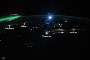
The glow of city lights, the aurora, and a rising Moon illuminate the night along the northwest coast of North…

Article

The Galaxy Next Door

3 min read

The Large Magellanic Cloud—one of our closest neighboring galaxies—is a hotbed of star formation that is visible to both astronauts…

Article

Five Minutes in Orbit

3 min read

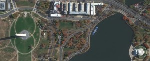
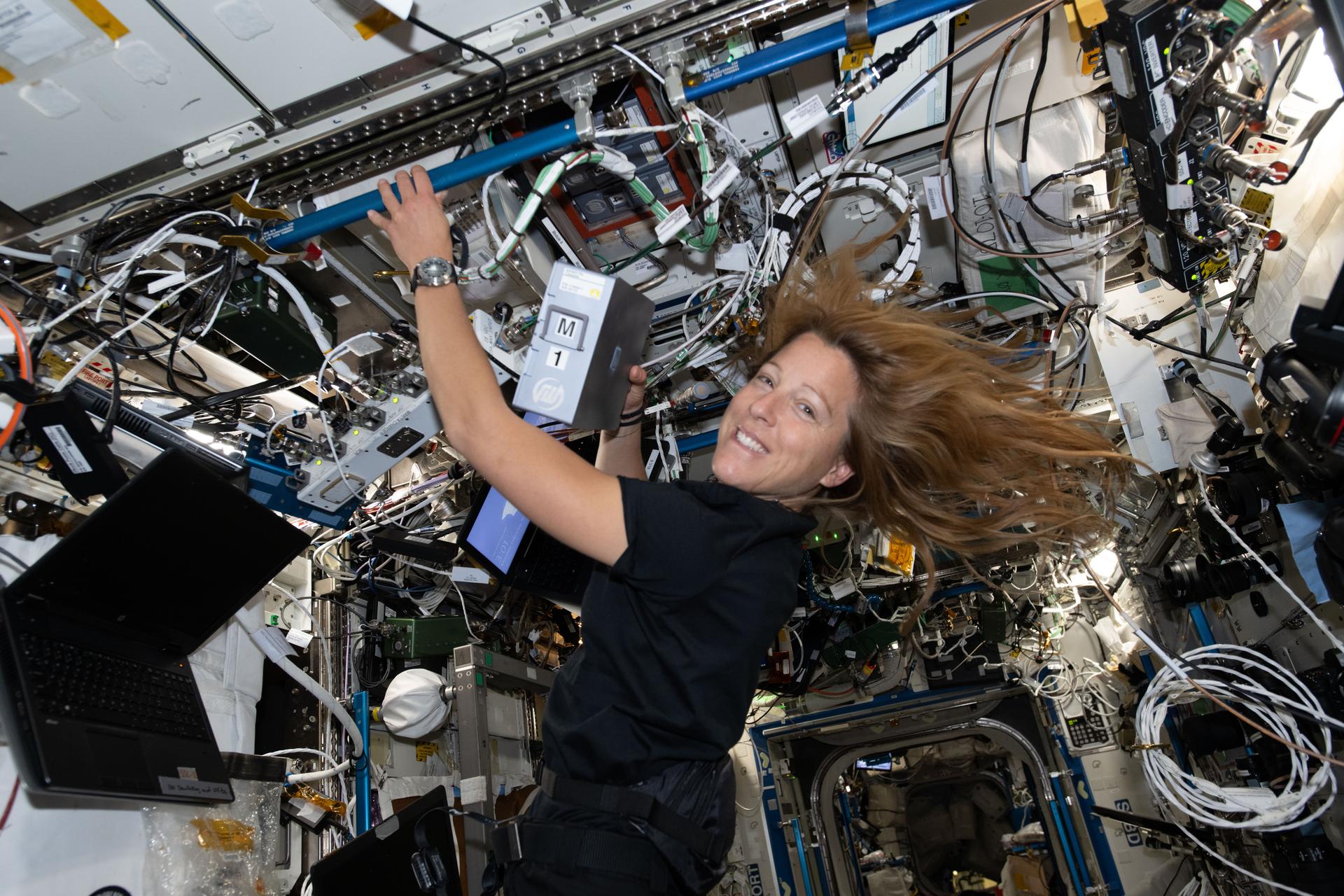
An astronaut captured a moonrise—and much more—in a series of photos taken from the International Space Station.

Article

Powered by WPeMatico

Get The Details…

Digital Surface and Terrain Models from Vantor’s Precision3D Product Line Added to Satellite Data Explorer

Digital Surface and Terrain Models from Vantor’s Precision3D Product Line Added to Satellite Data Explorer

4 min read

Digital Surface and Terrain Models from Vantor’s Precision3D Product Line Added to Satellite Data Explorer

An image from a Vantor Digital Surface Model showing a suburban area outside of Phoenix, Arizona.

NASA’s Commercial Satellite Data Acquisition (CSDA) Program announces the addition of three digital elevation and digital terrain products from Vantor’s Precision3D Product Line to its Satellite Data Explorer (SDX) data access and discovery tool.

The products include:

Digital Surface Model (DSM) at 1-meter spatial resolution The DSM is a 3D elevation model derived from imagery captured by Vantor’s constellation of Worldview satellites. It provides precise measurements across all surfaces and terrains and is available in standard formats to facilitate integration into a range of workflows and analysis. It is suitable for a range of applications requiring detailed elevation data, such as urban planning, environmental monitoring, disaster mitigation and response, and terrain mapping.
Digital Terrain Model (DTM) at 1-meter spatial resolution The DTM is a 3D elevation model derived from the DSM that offers bare-earth elevation data by removing above-ground features like vegetation and buildings and is designed for analyzing terrain and topography. Created with  automated processing techniques, the DTM ensures consistency across all terrain types and is available in a variety of in user-friendly formats.
 
Elevation Bundle (DSM + DTM) at 1-, 2-, and 4-meter spatial resolution The Elevation Bundle, which combines the DSM and DTM products, provides a detailed view of both above-ground features and the underlying bare earth. With global coverage and high-resolution data at 1-, 2-, and 4-meter resolution, this product offers reliable elevation information in all types of terrain, making it a suitable tool for a range of applications from slope analysis to flood modeling.

“Digital Elevation Models are foundational geospatial infrastructure for NASA’s science community, and including them in the CSDA program ensures broad, consistent access to high‑quality commercial terrain data that sharpen geometric accuracy, support Earth system and hazard modeling, and extend NASA’s capabilities in support of Earth action priorities,” said Dana Ostrenga, Project Manager for the CSDA.

About SDX

The SDX allows users to search, discover, and access data acquired through the CSDA program.  The web tool offers streamlined data download, automated quota tracking, and a new coverage map that provides a high-level overview of the regions covered by of the data discoverable through the SDX for any specified month and year. Currently, SDX offers access to the EarthDEM digital elevation model created by the Polar Geospatial Center at the University of Minnesota and now Vantor (formerly Maxar). For a summary of the NASA commercial partner datasets available in SDX, visit the SDX website.

Researchers interested in accessing these data in SDX can use their Earthdata Login for authentication and initiate data download requests. Data will be made available for download upon approval and acceptance of the end user license agreement (EULA). The use of these digital elevation and digital terrain products is governed by a United States government End User License Agreement (USG EULA).

To order data from SDX, users must create an account with and be logged in to NASA Earthdata.  (The initial attempt to use SDX will redirect users to Earthdata Login, where they will be prompted to enter their Earthdata credentials and accept the terms of the EULA.) Users must agree to the terms of the EULA before any data can be requested.  Note: All data requests must be approved by CSDA data managers. 

About the CSDA Program

NASA’s Earth Science Division (ESD) established the CSDA Program to identify, evaluate, and acquire data from commercial providers that to support NASA’s Earth science research and applications. NASA recognizes the potential of commercial satellite constellations to advance Earth System Science and applications for societal benefit and believes commercially acquired data can augment the Earth observations acquired by NASA, other U.S. government agencies, and NASA’s international partners.

All data from CSDA contract-awarded vendors are evaluated by the investigator-led CSDA project teams that assess the value of adding a vendor’s data to CSDA’s data holdings based on their quality and how they might benefit in the context of NASA Earth science research and applications. To learn about the program, its commercial partners, data evaluation process, and more, visit the CSDA website.

Learning Resources

For more information on the CSDA Program’s SDX, see the SDX user guide.

Share

Details

Last Updated
Feb 18, 2026

Related Terms

Powered by WPeMatico

Get The Details…

New Expedition 74 Foursome Kicks off Science, Gets Used to Space

New Expedition 74 Foursome Kicks off Science, Gets Used to Space

ESA (European Space Agency) astronaut and Expedition 74 Flight Engineer Sophie Adenot swaps hard drives inside the Advanced Space Experiment Processor-4 (ADSEP-4). Located aboard the International Space Station's Destiny laboratory module, the ADESP-4 houses and processes research samples for an array of microbiology and physics studies and can be operated onboard the Dragon and Cygnus spacecraft, as well as the orbital outpost.
ESA (European Space Agency) astronaut Sophie Adenot swaps sample processing hard drives inside the International Space Station’s Destiny laboratory module. The scientific hardware processes research samples for an array of microbiology and physics experiments.
NASA/Chris Williams

Vein scans and pharmaceutical research topped the science schedule aboard the International Space Station on Wednesday. The Expedition 74 crew rounded out the day with Dragon cargo transfers, lab familiarization activities, and life support maintenance duties.

NASA Flight Engineers Jack Hathaway and Jessica Meir kicked off their shift with vein scans using the new Ultrasound 3 device delivered last year aboard the Cygnus XL spacecraft. Hathaway led the scans imaging Meir’s neck, shoulder, and leg veins while chest electrodes measured her heart cardiac activity as doctors on Earth assisted in real time. Hathaway then operated the Ultrasound 2 device and scanned the veins of ESA (European Space Agency) astronaut Sophie Adenot as doctors on the ground monitored. Living in space long term induces fluid shifts in an astronaut’s body increasing the risk of blood clots—also called thromboembolism—that flight surgeons constantly monitor and seek to counteract.

The trio, along with Roscosmos cosmonaut Andrey Fedyaev, continued getting familiar with station systems and operations while getting used to living and working in weightlessness. At the beginning of his shift, Fedyaev wore acoustic sensors around his neck that recorded his rapid exhalation helping doctors understand how microgravity affects the respiratory system. Adenot serviced sample processing hardware supporting research into the development and manufacturing of pharmaceuticals in space. Meir wrapped up her day unpacking crew supplies and station hardware delivered aboard Dragon on Saturday.

NASA Flight Engineer Chris Williams, who has been aboard the orbital outpost since November, worked throughout Wednesday with a variety of life support tasks, medical training, and an emergency drill. Williams first measured airflow throughout the modules in the station’s U.S. segment then inspected vents for cleanliness and proper configuration. Next, he trained to use medical hardware, including an automated external defibrillator, and performed different procedures such as conducting eye exams and administering medicine. Williams also joined his crewmates Sergey Kud-Sverchkov and Sergei Mikaev from Roscosmos and practiced using emergency respirators in the unlikely event of a chemical leak aboard the station.

Kud-Sverchkov and Mikaev, who arrived with Williams aboard the Soyuz MS-28 spacecraft, spent Wednesday focusing primarily on research and maintenance in the station’s Roscosmos segment. Kud-Sverchkov wrapped up an overnight automated photography session that imaged the Earth’s nighttime atmosphere in near-ultraviolet wavelengths. Mikaev configured scientific hardware that controls and processes data for numerous experiments. The duo also split their day with computer hardware replacements in the Nauka science module and ventilation system maintenance in the Zvezda service module.

Learn more about station activities by following the space station blog, @space_station on X, as well as the ISS Facebook and ISS Instagram accounts.

Get the latest from NASA delivered every week. Subscribe here.

Powered by WPeMatico

Get The Details…

Mark A. Garcia

Fishing Boats and City Lights

Fishing Boats and City Lights

Fishing boats illuminate the Arabian Sea along India’s west coast with green lights designed to attract squid, shrimp, sardines, and mackerel in this nighttime photograph from the International Space Station, orbiting 259 miles above Earth. At lower right, the city lights of Hyderabad—renowned for its historic diamond and pearl trade—stretch westward toward the Mumbai Metropolitan Region, home to over 26 million people and the heart of Bollywood.

Powered by WPeMatico

Get The Details…

Vantor Archive Imagery Added to Satellite Data Explorer

Vantor Archive Imagery Added to Satellite Data Explorer

4 min read

Vantor Archive Imagery Added to Satellite Data Explorer

A multispectral satellite image from Vantor of Washington, DC. The
A high-resolution multispectral image of Washington, DC from Vantor. Visible are the Washington Monument (left), Tidal Basin (the body of water in the center-right), and the Jefferson Memorial (right).
Credit: Vantor

NASA’s Commercial Satellite Data Acquisition (CSDA) Program announces the addition of imagery from Vantor to its Satellite Data Explorer (SDX) data access and discovery tool. The imagery, which was obtained by Vantor’s Legion satellites, comes from Vantor’s 125-plus petabyte imagery archive, which dates back to 1999. The imagery from this archive contains a mix of panchromatic (black/white) and color imagery (up to 18 multispectral bands) and offers global coverage of up to 30 cm resolution.

There are three types of imagery available from this archive in SDX:

System-Ready Level 1B Data This data is idea for users who are looking to apply their own tools and models to fully process the data and extract the information that they need. It comes with all bands, full bit-depth, and requires further processing to be ready for deriving downstream analytics. This basic processing of this product offers an imagery product ready for custom orthorectification.
View-Ready Level 2A Data This processing level is intended for users who want to get straight to using the data to extract downstream analytical information. It provides a basis for deriving downstream analytics and has been orthorectified against a coarse digital elevation model (DEM). It comes with all bands and full bit depth.
Map-Ready 3-D This data product offers standardized and orthorectified (i.e., corrected to remove distortion caused by terrain variations, and sensor angle), imagery that has been radiometrically calibrated and geo-rectified to produce a highly accurate imagery product ready for seamless integration into workflows. Map-ready data is ideal for image viewing and locational referencing and offers a high degree of cartographic accuracy.

Vantor’s Legion satellites offer 8-band visible and near-infrared multispectral imagery at a resolution of up to 30-centimeters for use in a wide variety of applications ranging from agriculture and natural resources monitoring to disaster response and environmental surveillance.

Further, the addition of these datasets to the CSDA Program’s SDX enhances the tool’s utility for users within the larger NASA’s Earth observation community to find high-resolution data that meets their needs.

“NASA established the CSDA Program is to identify, evaluate, and acquire data from commercial sources that support NASA’s Earth science research and application goals,” said CSDA Project Manager Dana Ostrenga. “The inclusion of these Vantor data products in SDX is an example of our focus on realizing that mission and marks yet another step to our goal of bringing high-quality data from NASA’s commercial partners to users within the Earth observation science community.”

About SDX

The SDX allows users to search, discover, and access a variety of Global Navigation Satellite System (GNSS), digital elevation model (DEM), synthetic aperture radar (SAR), multispectral, and precipitation radar data acquired through the CSDA program. It also provides streamlined data download, automated quota tracking, and a new coverage map that provides a high-level overview of the spatial coverage of the data discoverable through the SDX for any specified month and year.  For a summary of the NASA commercial partner datasets available in SDX, visit the SDX website.

Researchers interested in accessing these data in SDX can use their Earthdata Login for authentication and initiate data download requests. Data will be made available for download upon approval and acceptance of the end user license agreement (EULA).

To order data from SDX, users must create an account with and be logged in to NASA Earthdata.  (The initial attempt to use SDX will redirect users to Earthdata Login, where they will be prompted to enter their Earthdata credentials and accept the terms of the EULA.) Users must agree to the terms of the EULA before any data can be requested.  Note: All data requests must be approved by CSDA data managers. 

About the CSDA Program

NASA’s Earth Science Division (ESD) established the CSDA Program to identify, evaluate, and acquire data from commercial providers that to support NASA’s Earth science research and applications. NASA recognizes the potential of commercial satellite constellations to advance Earth System Science and applications for societal benefit and believes commercially acquired data may also can augment the Earth observations acquired by NASA, and other U.S. government agencies, and NASA’s international partners.

All data from CSDA contract-awarded vendors are evaluated by the investigator-led CSDA project teams that assess the value of adding a vendor’s data to CSDA’s data holdings based on their quality and how they might benefit in the context of NASA Earth science research and applications. To learn more about the program, its commercial partners, data evaluation process, and more, visit the CSDA website.

Learning Resources

For more information on the CSDA Program’s SDX, see the tool’s user guide.

Share

Details

Last Updated
Feb 18, 2026

Related Terms

Powered by WPeMatico

Get The Details…