NASA’s IMAP Arrives at NASA Marshall For Testing in XRCF  

NASA’s IMAP Arrives at NASA Marshall For Testing in XRCF  

3 Min Read

NASA’s IMAP Arrives at NASA Marshall For Testing in XRCF  

The IMAP mission inside the circular thermal vacuum chamber with a purple background.

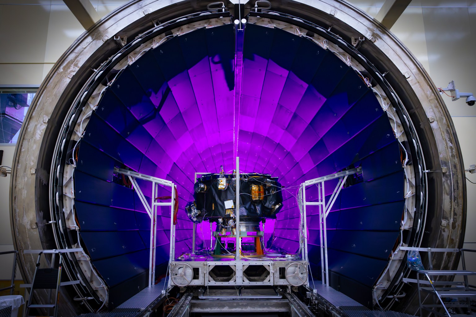
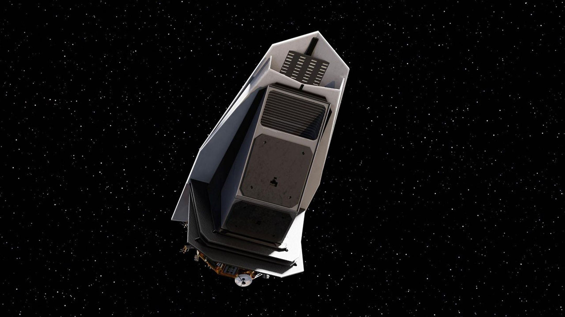
On March 18, NASA’s IMAP (Interstellar Mapping and Acceleration Probe) arrived at NASA’s Marshall Space Flight Center in Huntsville, Alabama, for thermal vacuum testing at the X-ray and Cryogenic Facility, which simulates the harsh conditions of space.

The IMAP mission is a modern-day celestial cartographer that will map the solar system by studying the heliosphere, a giant bubble created by the Sun’s solar wind that surrounds our solar system and protects it from harmful interstellar radiation. 

NASA’s IMAP mission being loaded into the thermal vacuum chamber of NASA Marshall Space Flight Center’s X-Ray and Cryogenic Facility (XRCF) in Huntsville, Alabama. IMAP arrived at Marshall March 18 and was loaded into the chamber March 19.
Credit: NASA/Johns Hopkins APL/Princeton/Ed Whitman

Testing performed in the X-ray and Cryogenic Facility will help to assess the spacecraft before its journey toward the Sun. The IMAP mission will orbit the Sun at a location called Lagrange Point 1 (L1), which is about one million miles from Earth towards the Sun. From this location, IMAP can measure the local solar wind and scan the distant heliosphere without background from planets and their magnetic fields. The mission will use its suite of ten instruments to map the boundary of the heliosphere, analyze the composition of interstellar particles that make it through, and investigate how particles change as they move through the solar system. 

Furthermore, IMAP will maintain a continuous broadcast of near real-time space weather data from five instruments aboard IMAP that will be used to test new space weather prediction models and improve our understanding of effects impacting our human exploration of space. 

Team members from Marshall Space Flight Center in Huntsville, Alabama, install IMAP into the XRCF’s chamber dome before the start of the thermal vacuum test. 
NASA/Johns Hopkins APL/Princeton/Ed Whitman

While inside the Marshall facility, the spacecraft will undergo dramatic temperature changes to simulate the environment during launch, on the journey toward the Sun, and at its final orbiting point. The testing facility has multiple capabilities including a large thermal vacuum chamber which simulates the harsh conditions of space such as extreme temperatures and the near-total absence of an atmosphere. Simulating these conditions before launch allow scientists and engineers to identify successes and potential failures in the design of the spacecraft. 

Team members from Marshall Space Flight Center in Huntsville, Alabama work to close the chamber door of the XRCF for IMAP testing. The chamber is 20 feet in diameter and 60 feet long making it one of the largest across NASA.
NASA/Johns Hopkins APL/Princeton/Ed Whitman

“The X-ray and Cryogenic Facility was an ideal testing location for IMAP given the chamber’s size, availability, and ability to meet or exceed the required test parameters including strict contamination control, shroud temperature, and vacuum level,” said Jeff Kegley, chief of Marshall’s Science Test Branch. 

The facility’s main chamber is 20 feet in diameter and 60 feet long, making it the 5th largest thermal vacuum chamber at NASA. It’s the only chamber that is adjoined to an ISO 6 cleanroom — a controlled environment that limits the number and size of airborne particles to minimize contamination. 

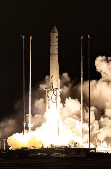
The IMAP mission will launch on a SpaceX Falcon 9 rocket from NASA’s Kennedy Space Center in Florida, no earlier than September. 

The IMAP mission inside the circular thermal vacuum chamber with a purple background.
NASA’s IMAP mission was loaded into NASA Marshall’s XRCF thermal vacuum chamber where the spacecraft will undergo testing such as dramatic temperature changes to simulate the harsh environment of space.
NASA/Johns Hopkins APL/Princeton/Ed Whitman

Media Contact:

Lane Figueroa
Marshall Space Flight Center
Huntsville, Alabama
256.544.0034
lane.e.figueroa@nasa.gov

Powered by WPeMatico

Get The Details…
Beth Ridgeway

Hubble Captures a Star’s Swan Song

Hubble Captures a Star’s Swan Song

2 min read

Hubble Captures a Star’s Swan Song

The image holds a planetary nebula, a glowing shell of material thrown off by a dying star. A glowing, jagged ring encircles a small central region of greenish clouds, making it appear like a hole torn in fabric. This “hole” is itself encircled by a band of silvery-blue clouds and a larger, fainter, yellow ring of gas. Puffy, smoky clouds of orange and red gas billow out from there into a large oval nebula, fading into the dark background of space dotted by stars.
This NASA/ESA Hubble Space Telescope image features the planetary nebula Kohoutek 4-55.
ESA/Hubble & NASA, K. Noll

The swirling, paint-like clouds in the darkness of space in this stunning image seem surreal, like a portal to another world opening before us. In fact, the subject of this NASA/ESA Hubble Space Telescope image is very real. We are seeing vast clouds of ionized atoms thrown into space by a dying star. This is a planetary nebula named Kohoutek 4-55, a member of the Milky Way galaxy situated just 4,600 light-years away in the constellation Cygnus (the Swan).

Planetary nebulae are the spectacular final display at the end of a giant star’s life. Once a red giant star has exhausted its available fuel and shed its last layers of gas, its compact core will contract further, enabling a final burst of nuclear fusion. The exposed core reaches extremely hot temperatures, radiating ultraviolet light that energizes the enormous clouds of gas cast off by the star. The ultraviolet light ionizes atoms in the gas, making the clouds glow brightly. In this image, red and orange indicate nitrogen, green is hydrogen, and blue shows oxygen. Kohoutek 4-55 has an uncommon, multi-layered form: a faint layer of gas surrounds a bright inner ring, all wrapped in a broad halo of ionized nitrogen. The spectacle is bittersweet, as the brief phase of fusion in the core will end after only tens of thousands of years, leaving a white dwarf that will never illuminate the clouds around it again.

This image itself was also the final work of one of Hubble’s instruments: the Wide Field and Planetary Camera 2 (WFPC2). Installed in 1993 to replace the original Wide Field and Planetary Camera, WFPC2 was responsible for some of Hubble’s most enduring images and fascinating discoveries. Hubble’s Wide Field Camera 3 replaced WFPC2 in 2009, during Hubble’s final servicing mission. A mere ten days before astronauts removed Hubble’s WFPC2 from the telescope, the instrument collected the data used in this image: a fitting send-off after 16 years of discoveries. Image processors used the latest and most advanced processing techniques to bring the data to life one more time, producing this breathtaking new view of Kohoutek 4-55.

Powered by WPeMatico

Get The Details…

How NASA Science Data Defends Earth from Asteroids

How NASA Science Data Defends Earth from Asteroids

5 min read

How NASA Science Data Defends Earth from Asteroids

This illustration depicts NASA's Double Asteroid Redirection Test (DART) spacecraft prior to impact at the Didymos binary asteroid system.
Artist’s impression of NASA’s DART mission, which collided with the asteroid Dimorphos in 2022 to test planetary defense techniques. Open science data practices help researchers identify asteroids that pose a hazard to Earth, opening the possibility for deflection should an impact threat be identified.
NASA/Johns Hopkins APL/Steve Gribben

The asteroid 2024 YR4 made headlines in February with the news that it had a chance of hitting Earth on Dec. 22, 2032, as determined by an analysis from NASA’s Center for Near Earth Object Studies (CNEOS) at the agency’s Jet Propulsion Laboratory in Southern California. The probability of collision peaked at over 3% on Feb. 18 — the highest ever recorded for an object of its size. This sparked concerns about the damage the asteroid might do should it hit Earth.

New data collected in the following days lowered the probability to well under 1%, and 2024 YR4 is no longer considered a potential Earth impactor. However, the event underscored the importance of surveying asteroid populations to reveal possible threats to Earth. Sharing scientific data widely allows scientists to determine the risk posed by the near-Earth asteroid population and increases the chances of identifying future asteroid impact hazards in NASA science data.

“The planetary defense community realizes the value of making data products available to everyone,” said James “Gerbs” Bauer, the principal investigator for NASA’s Planetary Data System Small Bodies Node at the University of Maryland in College Park, Maryland.

How Scientists Spot Asteroids That Could Hit Earth

Professional scientists and citizen scientists worldwide play a role in tracking asteroids. The Minor Planet Center, which is housed at the Smithsonian Astrophysical Observatory in Cambridge, Massachusetts, collects and verifies vast numbers of asteroid and comet position observations submitted from around the globe. NASA’s Small Bodies Node distributes the data from the Minor Planet Center for anyone who wants to access and use it.

A near-Earth object (NEO) is an asteroid or comet whose orbit brings it within 120 million miles of the Sun, which means it can circulate through Earth’s orbital neighborhood. If a newly discovered object looks like it might be an NEO, information about the object appears on the Minor Planet Center’s NEO Confirmation Page. Members of the planetary science community, whether or not they are professional scientists, are encouraged to follow up on these objects to discover where they’re heading.

Image of asteroid 2024 YR4
The asteroid 2024 YR4 as viewed on January 27, 2025. The image was taken by the Magdalena Ridge 2.4m telescope, one of the largest telescopes in NASA’s Planetary Defense network. Asteroid position information from observations such as this one are shared through the Minor Planet Center and NASA’s Small Bodies Node to help scientists pinpoint the chances of asteroids colliding with Earth.
NASA/Magdalena Ridge 2.4m telescope/New Mexico Institute of Technology/Ryan

When an asteroid’s trajectory looks concerning, CNEOS alerts NASA’s Planetary Defense Coordination Office at NASA Headquarters in Washington, which manages NASA’s ongoing effort to protect Earth from dangerous asteroids. NASA’s Planetary Defense Coordination Office also coordinates the International Asteroid Warning Network (IAWN), which is the worldwide collaboration of asteroid observers and modelers.

Orbit analysis centers such as CNEOS perform finer calculations to nail down the probability of an asteroid colliding with Earth. The open nature of the data allows the community to collaborate and compare, ensuring the most accurate determinations possible.

How NASA Discovered Risks of Asteroid 2024 YR4

The asteroid 2024 YR4 was initially discovered by the NASA-funded ATLAS (Asteroid Terrestrial-impact Last Alert System) survey, which aims to discover potentially hazardous asteroids. Scientists studied additional data about the asteroid from different observatories funded by NASA and from other telescopes across the IAWN.

At first, 2024 YR4 had a broad uncertainty in its future trajectory that passed over Earth. As the planetary defense community collected more observations, the range of possibilities for the asteroid’s future position on Dec. 22, 2032 clustered over Earth, raising the apparent chances of collision. However, with the addition of even more data points, the cluster of possibilities eventually moved off Earth.

This visualization from the NASA JPL Center for Near-Earth Object Studies shows the evolution of the risk corridor for asteroid 2024 YR4, using data from observations made up to Feb. 23, 2025. Each yellow dot represents the asteroid’s possible location on Dec. 22, 2032. As the range of possible locations narrowed, the dots at first converged on Earth, before skewing away harmlessly.
This visualization from NASA’s Center for Near Earth Object Studies shows the evolution of the risk corridor for asteroid 2024 YR4, using data from observations made up to Feb. 23, 2025. Each yellow dot represents the asteroid’s possible location on Dec. 22, 2032. As the range of possible locations narrowed, the dots at first converged on Earth, before skewing away harmlessly.
NASA/JPL/CNEOS

Having multiple streams of data available for analysis helps scientists quickly learn more about NEOs. This sometimes involves using data from observatories that are mainly used for astrophysics or heliophysics surveys, rather than for tracking asteroids.

“The planetary defense community both benefits from and is beneficial to the larger planetary and astronomy related ecosystem,” said Bauer, who is also a research professor in the Department of Astronomy at the University of Maryland. “Much of the NEO survey data can also be used for searching astrophysical transients like supernova events. Likewise, astrophysical sky surveys produce data of interest to the planetary defense community.”

How Does NASA Stop Asteroids From Hitting Earth?

In 2022, NASA’s DART (Double Asteroid Redirection Test) mission successfully impacted with the asteroid Dimorphos, shortening the time it takes to orbit around its companion asteroid Didymos by 33 minutes. Didymos had no chance of hitting Earth, but the DART mission’s success means that NASA has a tested technique to consider when addressing a future asteroid potential impact threat.

Artist’s impression of NASA’s upcoming NEO Surveyor mission, which will search for potentially hazardous near-Earth objects. The mission will follow open data practices to improve the chances of identifying dangerous asteroids.
NASA/JPL-Caltech

To increase the chances of discovering asteroid threats to Earth well in advance, NASA is working on a new space-based observatory, NEO Surveyor, which will be the first spacecraft specifically designed to look for asteroids and comets that pose a hazard to Earth. The mission is expected to launch in the fall of 2027, and the data it collects will be available to everyone through NASA archives.

“Many of the NEOs that pose a risk to Earth remain to be found,” Bauer said. “An asteroid impact has a very low likelihood at any given time, but consequences could be high, and open science is an       important component to being vigilant.”

For more information about NASA’s approach to sharing science data, visit:

https://science.nasa.gov/open-science.

By Lauren Leese 
Web Content Strategist for the Office of the Chief Science Data Officer 

Share

Details

Last Updated
Apr 10, 2025
Keep Exploring

Discover More Topics From NASA

Powered by WPeMatico

Get The Details…

Cardiovascular Research Continues Before Crew Departure, Next Cargo Mission

Cardiovascular Research Continues Before Crew Departure, Next Cargo Mission

The boot of Italy well-defined by the nation's city lights stands in contrast to the Tyrrhenian Sea (left) and the Adriatic Sea (right) with the Balkans at far right underneath an atmospheric glow blanketing Earth's horizon. The International Space Station was orbiting 262 miles above southern Europe at 10:57 p.m. local time when this photograph was taken.
The boot of Italy well-defined by the nation’s city lights stands in contrast to the Tyrrhenian Sea (left) and the Adriatic Sea (right) with the Balkans at far right underneath an atmospheric glow blanketing Earth’s horizon.
NASA

Preventing space-caused head and eye pressure and observing how blood flows in weightlessness were the top research objectives aboard the International Space Station on Thursday. The Expedition 72 crew is also preparing to split up while getting ready for the next U.S. cargo mission this month.

Doctors are testing a specialized thigh cuff for its ability to reduce blood flow toward an astronaut’s upper body caused by microgravity. Nichole Ayers of NASA assisted Takuya Onishi of JAXA (Japan Aerospace Exploration Agency) while he wore a pair of the thigh cuffs on his left and right legs. Ayers then scanned Onishi’s legs with the Ultrasound 2 device and collected blood pressure measurements to determine the effectiveness of the thigh cuffs. She also checked his eyes using medical imaging hardware to detect potential eye structure changes, a possible symptom of living in space. Knowledge gained from the biomedical study could protect crews on long duration missions to the Moon, Mars, and beyond.

Roscosmos Flight Engineers Sergey Ryzhikov and Alexey Zubritsky participated in another circulatory system study that observes how blood flows from the head to the limbs and back again in weightlessness. The two cosmonauts, who just arrived at the orbital outpost on Tuesday, took turns wearing sensors on their forehead, fingers, and toes revealing how blood circulation adapts to microgravity. Doctors will use the data to monitor crew health and provide countermeasures to the effects of living and working in weightlessness. Ryzhikov and Zubritsky also continued unpacking cargo stowed aboard the Soyuz MS-27 spacecraft that launched the duo, along with NASA Flight Engineer Jonny Kim, to the station.

NASA Flight Engineer Don Pettit joined station Commander Alexey Ovchinin and Flight Engineer Ivan Vagner, both from Roscosmos, and checked their Sokol launch and entry suits for leaks. The trio wore the suits when they launched together aboard the Soyuz MS-26 crew ship and docked to the Rassvet module on Sept. 11, 2024. They will wear the suits again when they return to Earth on April 19 inside the Soyuz MS-26 completing a seven-month space research mission.

The next cargo mission from SpaceX is due to launch later this month replenishing Expedition 72 with new science experiments and crew supplies. Pettit and Kim worked together preparing for the Dragon spacecraft’s arrival gathering items for stowage aboard Dragon when it returns to Earth about four weeks later. Pettit also assisted Kim, who is in his third day aboard the orbital lab, as he worked out on the advanced resistive exercise device for the first time. NASA Flight Engineer Anne McClain spent her day in the Quest airlock cleaning life support components and swapping hardware on a pair of spacesuits. Working in the orbiting lab’s Roscosmos segment, Roscosmos Flight Engineer Kirill Peskov serviced plumbing gear and an oxygen generator throughout his shift on Thursday.

Learn more about station activities by following the space station blog, @space_station and @ISS_Research on X, as well as the ISS Facebook and ISS Instagram accounts.

Get the latest from NASA delivered every week. Subscribe here: https://www.nasa.gov/subscribe

Powered by WPeMatico

Get The Details…

Mark A. Garcia

GLOBE, NASA, and the Monsignor McClancy Memorial High School in Queens, New York

GLOBE, NASA, and the Monsignor McClancy Memorial High School in Queens, New York

4 min read

GLOBE, NASA, and the Monsignor McClancy Memorial High School in Queens, New York

When students actively participate in scientific investigations that connect to their everyday lives, something powerful happens: they begin to see themselves as scientists. This sense of relevance and ownership can spark a lifelong interest in science, technology, engineering, and math (STEM), paving the way for continued education and even future careers in these fields. Opportunities to engage directly with NASA science—like the one you’ll read about in this story—not only deepen students’ understanding of STEM concepts, but also nourish their curiosity and confidence. With the support of passionate educators, these moments of participation become stepping stones to a future in which students see themselves as contributors to real-world science.

In September 2021, Ms. Deanna Danke, a Monsignor McClancy Memorial High School mathematics teacher in Queens, New York, began teaching her students how to measure tree heights using trigonometry. Soon enough, Ms. Danke discovered the Global Learning and Observations to Benefit the Environment (GLOBE) Observer Trees Tool, and with her 150+ students, began taking tree height observations around the school, an activity that Ms. Danke and her students continue to participate in today. Her and her students’ hundreds of repeat tree height observations have provided student and professional researchers with clusters of measurements that can coincide with measurements made by NASA satellite instruments, allowing for a comparison of datasets that can be analyzed over time.

Due to the consistent tree height data collection resulting from this effort, Ms. Danke was asked to be a co-author on a peer-reviewed research paper that was published on June 21, 2022 in the Environmental Research Letters special journal “Focus on Public Participation in Environmental Research.” The paper, “The potential of citizen science data to complement satellite and airborne lidar tree height measurements: lessons from The GLOBE Program,” included data from the tree height observations reported by Ms. Danke and her students—an incredible achievement for everyone involved.

On March 21, 2025, Ms. Danke’s former and current students continued their inspiring adventures with NASA science by taking a trip to the NASA Wallops Flight Facility in Wallops Island, Virginia. Highlights from this trip included science and technology presentations by personnel from the Ice, Cloud, and land Elevation Satellite-2 (ICESat-2) and Global Precipitation Measurement (GPM) Missions, the Wallops Balloon Program Office, and the Wallops Machine Shop for Fabrication and Testing. The ICESat-2 presentation, in particular, included a discussion on the student-collected tree height data and how the ICESat-2 satellite makes tree height observations from space.

Ms. Danke’s work is a testament to the incredible impact educators can have when they connect classroom learning to authentic scientific discovery. By introducing her students to tools like the GLOBE Observer Trees Tool and facilitating meaningful contributions to NASA science, she opened the door to experiences most students only dream of—from collecting data that supports satellite missions to co-authoring peer-reviewed research and visiting NASA facilities. Stories like this remind us that when students are empowered to be part of real science, the possibilities—for learning, inspiration, and future careers in STEM—are truly limitless.

The GLOBE Observer app, used by Ms. Danke and her students, is made possible by the NASA Earth Science Education Collaborative (NESEC). This free mobile app includes four tools that enable citizen scientists to participate in NASA science: Clouds, Mosquito Habitat Mapper, Land Cover, and Trees. Learn more about ways that you can join and participate in this and other NASA Citizen Science projects. Through these projects, sometimes called “participatory science” projects, volunteers and amateurs have helped make thousands of important scientific discoveries, and they are open to everyone around the world (no citizenship required).

NESEC is supported by NASA under cooperative agreement award number NNX16AE28A and is part of NASA’s Science Activation Portfolio. Learn more about how Science Activation connects NASA science experts, real content, and experiences with community leaders to do science in ways that activate minds and promote deeper understanding of our world and beyond: https://science.nasa.gov/learn

An image of a map with buildings, vegetation, green circles containing a drawings of trees.
Map of tree height around the Monsignor McClancy Memorial High School from the GLOBE Program’s Visualization System.

I know this was an experience they will remember forever and they have already told me that they cannot wait to tell their future children about it. It was wonderful meeting you in person and being on site to get a real sense of what you are working on. The boys were especially fascinated by the last two stops on the tour and appreciated learning a little more about how tree height is measured. Thank you again for this incredible opportunity.”

Ms. Deanna Danke

Ms. Deanna Danke

Monsignor McClancy Memorial High School

Share

Details

Last Updated
Apr 10, 2025
Editor
NASA Science Editorial Team
Location
Wallops Flight Facility

Powered by WPeMatico

Get The Details…