Crew Packs Dragon for Thursday Departure and Keeps Up Research

Crew Packs Dragon for Thursday Departure and Keeps Up Research

The SpaceX Dragon cargo craft, with its nosecone open, approaches the International Space Station for an automated docking to the Harmony module's space-facing port. Dragon delivered about 6,700 pounds of new science experiments and crew supplies replenishing the Expedition 73 crew.
The SpaceX Dragon cargo craft, with its nosecone open, approaches the International Space Station for an automated docking to the Harmony module’s space-facing port. Dragon carrying about 6,700 pounds of new science experiments and crew supplies on April 22, 2025.
NASA

The SpaceX Dragon cargo spacecraft is one day away from departing the International Space Station and the Expedition 73 crew members are finishing packing it with science and cargo. The orbital residents also continued their life science activities and lab maintenance duties on Wednesday.

Four station astronauts worked together throughout their day loading several tons of completed science experiments and station hardware inside Dragon. NASA Flight Engineers Anne McClain and Nichole Ayers kicked off their shift loading and securing a variety of cargo inside the spacecraft ahead of its departure and undocking planned for 12:05 p.m. EDT on Thursday. Toward the end of their shift, they removed portable science freezers containing research samples from station EXPRESS racks and installed them inside Dragon.

Station Commander Takuya Onishi spent the majority of his day assisting with the Dragon loading as the U.S. spacecraft nears the end of 30 days docked to the Harmony module’s space-facing port. NASA Flight Engineer Jonny Kim, who will be on duty Thursday monitoring Dragon as it departs the station, also joined in on the cargo transfers. The four crew members will be back on cargo duty early Thursday loading time sensitive, critical research samples on Dragon for the ride back to Earth. NASA+ will begin its live broadcast of Dragon’s departure at 11:45 a.m. Thursday.

Numerous space science investigations continued on Wednesday exploring space agriculture and human research aboard the orbital outpost. Ayers, at the end of her shift, wrapped up a botany study in the Destiny laboratory module exploring if genetically modified tomato plants can grow with techniques other than photosynthesis. Kim activated a series of student-designed experiments investigating how microgravity affects different disease mechanisms possibly leading to new, more advanced therapies.

Veteran Roscosmos Flight Engineer Sergey Ryzhikov completed a 24-hour session disconnecting sensors that measured his heart activity and blood pressure. Next, Flight Engineer Alexey Zubritsky attached sensors to himself and began his 24-hour heart and blood pressure monitoring session. Ryzhikov later set up Earth observation hardware to image the planet’s nighttime atmosphere in ultraviolet wavelengths. Zubritskiy also pointed a camera at Earth imaging Brazil, Italy, Mauritania across a wide range of wavelengths.

Roscosmos Flight Engineer and first-time space flyer Kirill Peskov was back inside the Nauka science module working on maintenance of the European robotic arm (ERA). Kirill checked the ERA’s computer interface, safety features, and electrical systems. Nauka and the ERA were launched aboard a Proton rocket on July 21, 2021. Nauka with the ERA attached autonomously docked a few days later to the Zvezda service module’s Earth-facing port on July 29.

Learn more about station activities by following the space station blog, @space_station and @ISS_Research on X, as well as the ISS Facebook and ISS Instagram accounts.

Get the latest from NASA delivered every week. Subscribe here: https://www.nasa.gov/subscribe

Powered by WPeMatico

Get The Details…

Mark A. Garcia

What is Lunar Regolith? (Grades 5-8)

What is Lunar Regolith? (Grades 5-8)

5 Min Read

What is Lunar Regolith? (Grades 5-8)

This article is for students grades 5-8.

The surface of the Moon is covered in a thick layer of boulders, rocks, and dust. This dusty, rocky layer is called lunar regolith.  It was created a long time ago when meteorites crashed into the Moon and broke up the ground. NASA scientists study the regolith to learn more about the Moon’s history. But the smallest parts of the regolith make exploring the Moon very hard! That is why scientists are working to understand it better and to keep astronauts safe during future lunar missions.

What is lunar regolith like?

Lunar regolith is full of tiny, sharp pieces that can act like little bits of broken glass. Unlike the dust and soil on Earth, the smallest pieces of regolith have not been worn down by wind or rain. These bits are rough, jagged, and cling to everything they touch – boots, gloves, tools, and even spacecraft!  In pictures it might look like soft, harmless gray powder, but it is actually scratchy and can damage lunar landers, spacesuits, and robots. This makes working on the Moon a lot harder than it looks!

Image of Apollo astronaut boot print on the moon.

Is regolith harmful to astronauts?

The small parts of lunar regolith get stuck on spacesuits and can be brought inside the spacecraft. Once it is inside, it can cause some serious problems. The tiny, sharp pieces can make astronauts’ skin itchy, irritate their eyes, and even make them cough. If it gets into their lungs, it can make them sick. Scientists worry the damage from breathing in lunar regolith could keep bothering astronauts for a long time, even after they are back on Earth. That is why NASA scientists and technologists are working hard to find smart ways to deal with regolith and protect astronauts!

Three people in white astronaut suits with helmets and orange gloves stand in an area of sand-like substance, holding science instruments. One instrument in buried slightly in the sand

Can regolith damage NASA equipment?

Regolith doesn’t just cause trouble for astronauts. It can also damage important machines! It can scratch tools and cover up solar panels, causing them to stop working. It can also clog radiators, which are used to keep machines cool. The small bits of regolith can make surfaces slippery and hard to walk on. It can even make it tough for robots to move around. Unlike Earth’s soil, the Moon’s regolith isn’t packed down. Any time we move things around on the Moon’s surface, we spread the rough, dusty particles around. Can you imagine what a mess launching and landing a spacecraft would make?

All of this can make exploring the Moon much more difficult and even dangerous!

A electrodynamic dust shield device is centered in this photo with a blue wire in the background.

What is NASA doing to understand lunar regolith?

NASA is building many cool technologies to help deal with the harm regolith can cause. One of the tools technologists have already developed is call an Electrodynamic Dust Shield (EDS). It uses electricity to create a kind of force field that pushes the small particles away from tools on the Moon!

There are many ways NASA is working to understand lunar regolith. One interesting way is by using special cameras and lasers on landers to watch how the regolith moves when a spacecraft lands. This system is called SCALPPS, which stands for Stereo Cameras for Lunar Plume-Surface Studies. SCALPSS helps scientists see how the lunar regolith gets blown around during landings. It helps scientists to measure the size of the regolith pieces and the amount that flies up into the air during landing.

The more NASA knows about how regolith behaves, the better they can plan for safe missions!

Career Corner

Many types of scientists and engineers work together to understand lunar regolith. If you want to study space, here are some cool jobs you could have!

Planetary Geologist: These scientists are like detectives. They study how the things in space were formed, how they have changed, and what they can tell us about the rest of the solar system. Their work helps us understand what is in space.

Chemist: Chemists look at space rocks and space dust. They want to know what these materials are made of and how they were created.

Astrobiologist: Astrobiologists are studying to find clues of life beyond Earth. They study space to find out if life ever existed – or could exist – somewhere else in the universe.

Planetary Scientist: These scientists use pictures, data from spacecraft, and even samples from rocks and dust to learn about other worlds. They explore space without ever leaving Earth!

Remote Sensing Scientist: These scientists use satellites, drones, and special cameras to study planets from far away. It is like being a space spy who looks for clues from above.

Engineers: Engineers solve problems! Civil engineers, materials engineers, and geotechnical engineers work together to understand how regolith can best be used for building materials and get useful resources on the Moon.

Explore More

Making Regolith Activity

Watch: Mitigating Lunar Dust

Watch: NASA SCALPSS

Watch: Surprisingly STEM: Exploration Geologist Surprisingly STEM: Moon Rock Processors

Powered by WPeMatico

Get The Details…
Loura Hall

NASA-French Satellite Spots Large-Scale River Waves for First Time

NASA-French Satellite Spots Large-Scale River Waves for First Time

6 min read

Preparations for Next Moonwalk Simulations Underway (and Underwater)

Yellowstone Rive
The SWOT satellite is helping scientists size up flood waves on waterways like the Yellowstone River, pictured here in October 2024 in Montana. SWOT measures the height of surface waters, including the ocean, and hundreds of thousands of rivers, lakes, and reservoirs in the U.S. alone.
NPS

In a first, researchers from NASA and Virginia Tech used satellite data to measure the height and speed of potentially hazardous flood waves traveling down U.S. rivers. The three waves they tracked were likely caused by extreme rainfall and by a loosened ice jam. While there is currently no database that compiles satellite data on river flood waves, the new study highlights the potential of space-based observations to aid hydrologists and engineers, especially those working in communities along river networks with limited flood control structures such as levees and flood gates.

Unlike ocean waves, which are ordinarily driven by wind and tides, and roll to shore at a steady clip, river waves (also called flood or flow waves) are temporary surges stretching tens to hundreds of miles. Typically caused by rainfall or seasonal snowmelt, they are essential to shuttling nutrients and organisms down a river. But they can also pose hazards: Extreme river waves triggered by a prolonged downpour or dam break can produce floods.

“Ocean waves are well known from surfing and sailing, but rivers are the arteries of the planet. We want to understand their dynamics,” said Cedric David, a hydrologist at NASA’s Jet Propulsion Laboratory in Southern California and a coauthor of a new study published May 14 in Geophysical Research Letters.

SWOT is depicted in orbit in this artist’s concept
SWOT is depicted in orbit in this artist’s concept, with sunlight glinting off one of its solar panels and both antennas of its key instrument — the Ka-band Radar Interferometer (KaRIn) — extended. The antennas collect data along a swath 30 miles (50 kilometers) wide on either side of the satellite.
CNES

Measuring Speed and Size

To search for river waves for her doctoral research, lead author Hana Thurman of Virginia Tech turned to a spacecraft launched in 2022. The SWOT (Surface Water and Ocean Topography) satellite is a collaboration between NASA and the French space agency CNES (Centre National d’Études Spatiales). It is surveying the height of nearly all of Earth’s surface waters, both fresh and salty, using its sensitive Ka-band Radar Interferometer (KaRIn). The instrument maps the elevation and width of water bodies by bouncing microwaves off the surface and timing how long the signal takes to return.

“In addition to monitoring total storage of waters in lakes and rivers, we zoom in on dynamics and impacts of water movement and change,” said Nadya Vinogradova Shiffer, SWOT program scientist at NASA Headquarters in Washington.

Thurman knew that SWOT has helped scientists track rising sea levels near the coast, spot tsunami slosh, and map the seafloor, but could she identify river height anomalies in the data indicating a wave on the move?

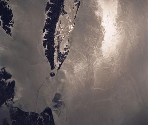
She found that the mission had caught three clear examples of river waves, including one that arose abruptly on the Yellowstone River in Montana in April 2023. As the satellite passed overhead, it observed a 9.1-foot-tall (2.8-meter-tall) crest flowing toward the Missouri River in North Dakota. It was divided into a dramatic 6.8-mile-long (11-kilometer-long) peak followed by a more drawn‐out tail. These details are exciting to see from orbit and illustrate the KaRIn instrument’s uniquely high spatial resolution, Thurman said.

Sleuthing through optical Sentinel-2 imagery of the area, she determined that the wave likely resulted from an ice jam breaking apart upstream and releasing pent-up water.

The other two river waves that Thurman and the team found were triggered by rainfall runoff. One, spotted by SWOT starting on Jan. 25, 2024, on the Colorado River south of Austin, Texas, was associated with the largest flood of the year on that section of river. Measuring over 30 feet (9 meters) tall and 166 miles (267 kilometers) long, it traveled around 3.5 feet (1.07 meters) per second for over 250 miles (400 kilometers) before discharging into Matagorda Bay.

The other wave originated on the Ocmulgee River near Macon, Georgia, in March 2024. Measuring over 20 feet (6 meters) tall and extending more than 100 miles (165 kilometers), it traveled about a foot (0.33 meters) per second for more than 124 miles (200 kilometers).

“We’re learning more about the shape and speed of flow waves, and how they change along long stretches of river,” Thurman said. “That could help us answer questions like, how fast could a flood get here and is infrastructure at risk?”

Complementary Observations

Engineers and water managers measuring river waves have long relied on stream gauges, which record water height and estimate discharge at fixed points along a river. In the United States, stream gauge networks are maintained by agencies including the U.S. Geological Survey. They are sparser in other parts of the world.

“Satellite data is complementary because it can help fill in the gaps,” said study supervisor George Allen, a hydrologist and remote sensing expert at Virginia Tech.

If stream gauges are like toll booths clocking cars as they pass, SWOT is like a traffic helicopter taking snapshots of the highway.

The wave speeds that SWOT helped determine were similar to those calculated using gauge data alone, Allen said, showing how the satellite could help monitor waves in river basins without gauges. Knowing where and why river waves develop can help scientists tracking changing flood patterns around the world.

Orbiting Earth multiple times each day, SWOT is expected to observe some 55% of large-scale floods at some stage in their life cycle. “If we see something in the data, we can say something,” David said of SWOT’s potential to flag dangerous floods in the making. “For a long time, we’ve stood on the banks of our rivers, but we’ve never seen them like we are now.”

More About SWOT

The SWOT satellite was jointly developed by NASA and CNES, with contributions from the Canadian Space Agency (CSA) and the UK Space Agency. NASA’s Jet Propulsion Laboratory, managed for the agency by Caltech in Pasadena, California, leads the U.S. component of the project. For the flight system payload, NASA provided the Ka-band radar interferometer (KaRIn) instrument, a GPS science receiver, a laser retroreflector, a two-beam microwave radiometer, and NASA instrument operations. The Doppler Orbitography and Radioposition Integrated by Satellite system, the dual frequency Poseidon altimeter (developed by Thales Alenia Space), the KaRIn radio-frequency subsystem (together with Thales Alenia Space and with support from the UK Space Agency), the satellite platform, and ground operations were provided by CNES. The KaRIn high-power transmitter assembly was provided by CSA.

News Media Contacts

Jane J. Lee / Andrew Wang
Jet Propulsion Laboratory, Pasadena, Calif.
818-354-0307 / 626-379-6874
Written by Sally Younger
2025-074

Share

Details

Last Updated

May 21, 2025

Powered by WPeMatico

Get The Details…
Anthony Greicius

Another Milestone for X-59

Another Milestone for X-59

A white plane sits in a hangar that has a curved ceiling. The plane has markings on it including a NASA logo and "X-59." Several people are inside the hangar as well.
NASA’s X-59 quiet supersonic research aircraft is seen during its “aluminum bird” systems testing at Lockheed Martin’s Skunk Works facility in Palmdale, California. The test verified how the aircraft’s hardware and software work together, responding to pilot inputs and handling injected system failures.
Lockheed Martin/Garry Tice

NASA’s X-59 quiet supersonic research aircraft successfully completed a critical series of tests in which the airplane was put through its paces for cruising high above the California desert – all without ever leaving the ground. The goal of ground-based simulation testing was to make sure the hardware and software that will allow the X-59 to fly safely are properly working together and able to handle any unexpected problems.

Learn more about this series of exercies, dubbed “aluminum bird” testing by engineers.

Image credit: Lockheed Martin/Garry Tice

Powered by WPeMatico

Get The Details…
Jim Banke

How Big is Space? We Asked a NASA Expert: Episode: 61

How Big is Space? We Asked a NASA Expert: Episode: 61

2 min read

Preparations for Next Moonwalk Simulations Underway (and Underwater)

How big is space?

Space is really big. Thinking about our solar system, let’s imagine you could get in a car and drive to Pluto at highway speeds. It would take you about 6,000 years to get there.

When we start to think about other stars outside of our solar system, we need to think about

another unit of distance. This is why astronomers use the unit light-years.

Light travels at 186,000 miles per second. One light year is about 6 trillion miles. The closest star to our Sun is about four light years away.

Our own Milky Way galaxy is about 100,000 light-years across.

We know from deep field images of the universe that there are hundreds of billions, perhaps a trillion other galaxies.

Using some of the deepest images yet from the James Webb Space Telescope, we’ve been able to see galaxies that emitted their light about 13 and a half billion years ago.

Now, here’s a really important thing. Because the universe is expanding, those most distant galaxies are actually much further away than 13 and a half billion light years.

I’m glossing over some math here, but we can estimate that the observable universe is about 92 billion light-years across. But we’re pretty sure that the universe is even bigger than what we can see.

And here’s where things get really weird, we don’t actually know if the universe is finite or infinite.

As much as we’ve learned about the universe, science has no reliable estimate of the actual size of the entire universe.

[END VIDEO TRANSCRIPT]

Full Episode List

Full YouTube Playlist

Powered by WPeMatico

Get The Details…
Emily Furfaro