Hubble Sees a Merged Galaxy

Hubble Sees a Merged Galaxy

2 min read

Hubble Sees a Merged Galaxy

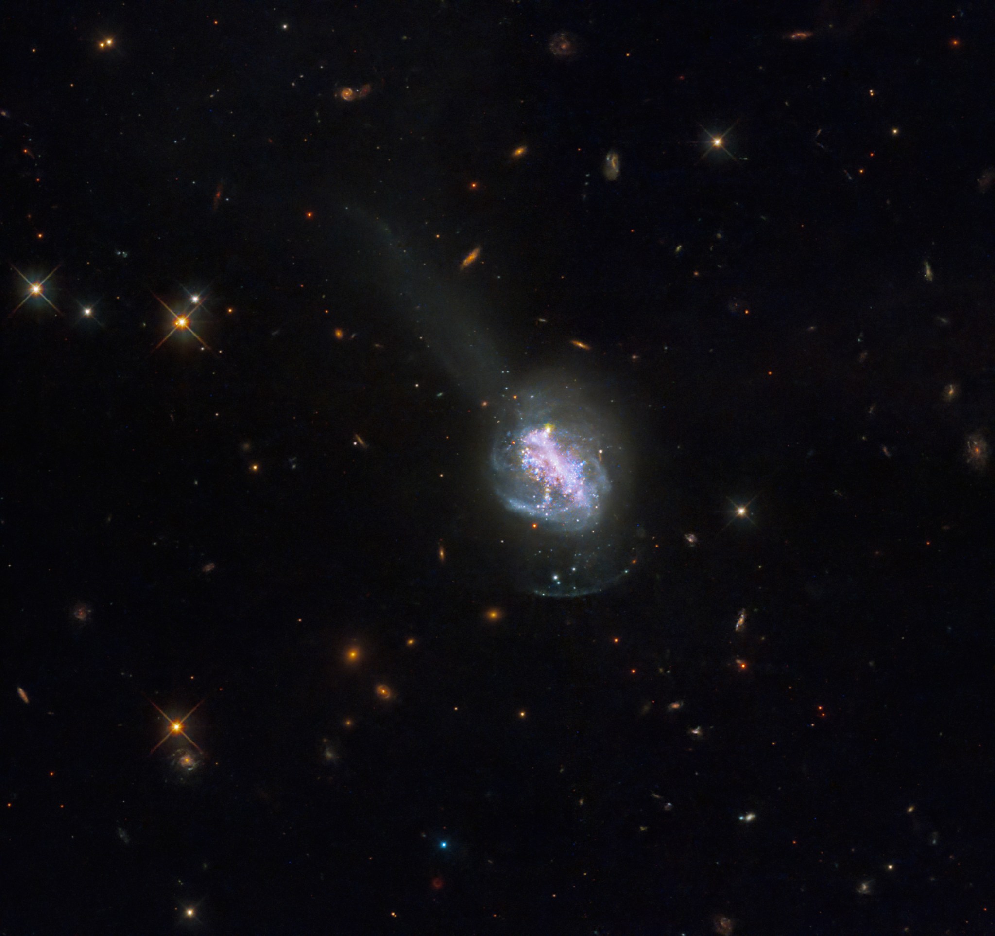
A bright, purplish galaxy glows at the image’s center, with blue stars interspersed and a blue-white haze extending outward, all against black space dotted with stars and distant galaxies.
This new NASA Hubble Space Telescope image reveals the luminous blue compact galaxy called ESO 185-IG013.
NASA, ESA, and R. Chandar (University of Toledo); Processing: Gladys Kober (NASA/Catholic University of America)

This new NASA Hubble Space Telescope image shows ESO 185-IG013, a luminous blue compact galaxy (BCG). BCGs are nearby galaxies that show an intense burst of star formation. They are unusually blue in visible light, which sets them apart from other high-starburst galaxies that emit more infrared light. Astrophysicists study BCGs because they provide a relatively close-by equivalent for galaxies from the early universe. This means that BCGs can help scientists learn about galaxy formation and evolution that may have been happening billions of years ago.

Hubble imaged ESO 185-IG013 in ultraviolet, visible, and infrared wavelengths to reveal details about its past. Hundreds of young star clusters, many of which are younger than 100 million years, populate the galaxy. A large number of star clusters are only 3.5 million years old – relative infants compared to the timescale of our universe. Scientists predict that many of these youngest clusters will not last, since young clusters can often perish after expelling too much of their gas. The large number of young star clusters indicates that this galaxy was part of a recent galaxy collision and merger. The perturbed structure of the galaxy, which likely occurred from the violent interactions of gas and dust during the collision, is another sign. The merger supplied the system with lots of fuel for star formation, which continues to take place today.

ESO 185-IG013 also contains a tidal shell, the diffuse glow surrounding its bright center, which is a common signal of galaxy mergers. Scientists believe that in a galaxy merger, the smaller of the two interacting galaxies gets disrupted by the larger galaxy, losing most of its material. This releases the material, which then gets pulled in again by the gravity of the larger galaxy. The dense area where the material gets repositioned is called the shell, and it contains many star clusters. In addition to the shell, ESO 185-IG013 boasts a tail of gas in the northeast.

All of the stars in the system have a combined mass more than 7 billion times that of our Sun. The system is located about 260 million light-years away.

LEARN MORE:

Media Contact:

Claire Andreoli
NASA’s Goddard Space Flight CenterGreenbelt, MD
claire.andreoli@nasa.gov

Share

Details

Last Updated
Feb 01, 2024
Editor
Andrea Gianopoulos
Location
Goddard Space Flight Center

Powered by WPeMatico

Get The Details…

NASA Science Arrives on Cygnus; Private Astronauts Prepare for Return

NASA Science Arrives on Cygnus; Private Astronauts Prepare for Return

The Cygnus space freighter, with its two cymbal-shaped UltraFlex solar arrays, is pictured in the grips of the Canadarm2 robotic arm after its capture on Feb. 1, 2024.

As part of NASA’s commercial resupply services, Northrop Grumman’s Cygnus cargo craft arrived at the International Space Station today packed with science and supplies for the Expedition 70 crew. The seven orbital outpost residents now turn their attention to the departure of four Axiom Mission 3 (Ax-3) visitors.

Cygnus was captured with the Canadarm2 robotic arm controlled by NASA Flight Engineer Loral O’Hara at 4:59 a.m. EST on Thursday. Shortly afterward, mission controllers on the ground took over control of the Canadarm2 and installed Cygnus to the Unity module’s Earth-facing port at 7:14 a.m.

About three hours later, O’Hara and NASA Flight Engineer Jasmin Moghbeli equalized pressure between Cygnus and the space station then opened Cygnus’ hatch to begin six months of cargo operations. They were followed by Commander Andreas Mogensen of ESA (European Space Agency) and Flight Engineer Satoshi Furukawa of JAXA (Japan Aerospace  Exploration Agency) who began unpacking new research samples and stowing them inside lab freezers for upcoming science investigations.

Mogensen also helped the four Ax-3 astronauts prepare for their departure from the station aboard the SpaceX Dragon Freedom spacecraft for no earlier than Saturday morning. Mission managers from Axiom Space, SpaceX, and NASA are monitoring weather conditions at the splashdown site off the coast of Florida before making a final undocking decision.

Ax-3 astronauts Michael López-Alegría and Walter Villadei packed completed science experiments in lab freezers and prepared them for stowage aboard their Dragon spacecraft Thursday morning. The duo then joined fellow Ax-3 crewmates Alper Gezeravcı and Marcus Wandt for a conference with mission controllers discussing the cargo that will be returning with them aboard Dragon.

All four private astronauts will join the seven-member Expedition 70 crew at 9:50 a.m. Friday, Feb. 2, for a farewell ceremony aboard the space station. The event will be broadcast live on the NASA+ streaming service, NASA TV, the NASA app, YouTube, and the agency’s website. Learn how to stream NASA TV through a variety of platforms, including social media.

The orbiting lab’s three cosmonauts worked throughout Thursday on their complement of science and cargo activities in the station’s Roscosmos segment. Flight Engineers Nikolai Chub and Konstantin Borisov carried out an Earth observation experiment to support educational and commercial opportunities on Earth. Afterward, Chub conducted a fluid physics study while Borisov began a 24-hour blood pressure monitoring session. Borisov later installed an ultraviolet camera to capture nighttime imagery of Earth’s atmosphere. Veteran cosmonaut Oleg Kononenko inventoried cargo in the Prichal docking module then stowed cargo inside the Progress 85 resupply ship docked to the rear of the Zvezda service module.

NASA will share more on Axiom Mission 3’s departure as available following the next weather review. The mission is the third private astronaut mission to the space station enabled by NASA.


Learn more about station activities by following the space station blog@space_station and @ISS_Research on X, as well as the ISS Facebook and ISS Instagram accounts.

Get weekly video highlights at: https://roundupreads.jsc.nasa.gov/videoupdate/

Get the latest from NASA delivered every week. Subscribe here: www.nasa.gov/subscribe

Powered by WPeMatico

Get The Details…

Mark Garcia

First Hot Fire Test of the Year for Artemis

First Hot Fire Test of the Year for Artemis

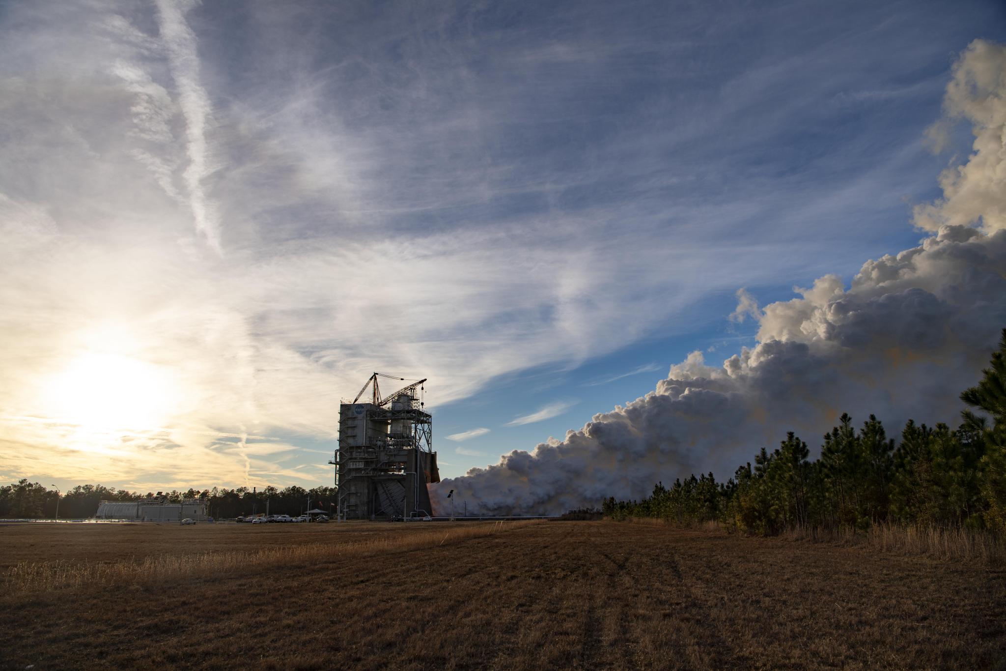
White vapor clouds billow up and to the right of this image during a hot fire test. The sun is a diffuse, bright yellow spot, covered by wispy clouds that dominate the sky.
NASA/Danny Nowlin

Clouds of white vapor pile up at NASA’s Stennis Space Center in Bay St. Louis, Mississippi, during a full-duration, 500-second hot fire of an RS-25 certification engine Jan. 17, 2024. This test series is critical for future flights of NASA’s SLS (Space Launch System) rocket in support of the Artemis campaign.

During the Jan. 17 test, operators followed a “test like you fly” approach, firing the engine for the same amount of time – almost eight-and-a-half minutes (500 seconds) – needed to launch SLS and at power levels ranging between 80% to 113%.

Image Credit: NASA/Danny Nowlin

Powered by WPeMatico

Get The Details…
Monika Luabeya

OpenET Moisture Measurement Tool is Proving Highly Accurate

OpenET Moisture Measurement Tool is Proving Highly Accurate

5 min read

OpenET Moisture Measurement Tool is Proving Highly Accurate

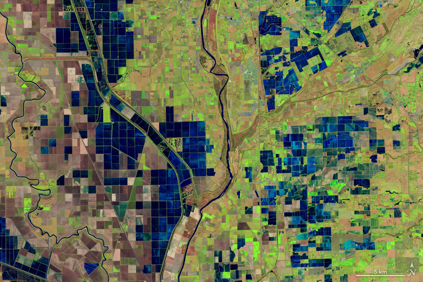
This satellite image centers the meandering Sacramento river surrounded by rice fields. The fields are broken into primarily square and rectangular areas with the fields nearest the river being full of green and brown vegetation, and farther from the river they are flooded and appear dark blue.
This is a false-color image, acquired December 26, 2018, with the OLI (Operational Land Imager) on Landsat 8, and shows flooded rice fields along the Sacramento and Feather Rivers. Inundated fields appear dark blue; vegetation is bright green.  
NASA Earth Observatory / Lauren Dauphin

As the world looks for sustainable solutions, a system tapping into NASA satellite data for water management has passed a critical test.

Called OpenET, the system uses an ensemble of six satellite-driven models that harness publicly available data from the Landsat program to calculate evapotranspiration (ET)—the movement of water vapor from soil and plant leaves into the atmosphere. OpenET does this on a field-level scale that is greatly improving the way farmers, ranchers, and water resource managers steward one of Earth’s most precious resources.

Researchers have now conducted a large-scale analysis of how well OpenET is tracking evapotranspiration over crops and natural landscapes. The team compared OpenET data with measurements from 152 sites with ground-based instruments across the United States. In agricultural areas, OpenET calculated evapotranspiration with high accuracy, especially for annual crops such as wheat, corn, soy, and rice. The researchers reported their findings on January 15 in Nature Water.

“I was pleasantly surprised by the results,” said John Volk, lead author of the study and assistant research scientist and software engineer at Desert Research Institute in Reno, Nev. “The accuracy in croplands was quite strong, particularly in western arid regions, which are important areas for agriculture and have water sustainability challenges.”

That’s welcome news for regions where OpenET data is already being put to work. In Northern California’s Sacramento-San Joaquin Delta, water resource managers are using OpenET to help farmers comply with state rules requiring them to report aspects of their water use. The new study “gives us more confidence that these numbers are accurate, and that OpenET is continually improving over time,” said Lindsay Kammeier, a senior engineer with the California State Water Board in Sacramento, who was not involved in the new research.

“ET is notoriously difficult to calculate,” she added. “Having a really accurate number helps us to make decisions to manage the environment, manage for agricultural uses, and manage for urban uses better and from a common understanding.”

Tracking the Invisible Movement of Water

While many people are familiar with what one inch of rainfall means, few stop to think about one inch of evapotranspiration returning to the atmosphere, said Forrest Melton, the OpenET project scientist at NASA’s Ames Research Center in California’s Silicon Valley. “OpenET is working to make the unseen process of evapotranspiration as easy to track as checking the amount of rainfall in the daily weather forecast.”

Evapotranspiration is the natural process in which water moves to the atmosphere from the surface. The term combines evaporation—water changing from liquid to gas (vapor) and rising from soil, lakes, and oceans—and transpiration, the “exhaling” by plants as they release moisture back into the air. After precipitation, evapotranspiration is one of the most important factors for estimating how much water is available for crops or other plants.

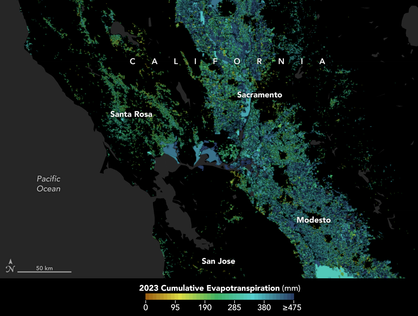
This map shows evapotranspiration levels across Central California including the Bay Area. Darker blue can be seen in the Central Valley.
In California, state officials and farmers are using satellite data through OpenET to track evapotranspiration to better manage water resources. The process is a window into the water consumed by plants and crops, such as those grown in the Central Valley.
NASA Earth Observatory using openetdata.org

For farmers and water managers, accurate data provides a measure of the amount of water required through irrigation to replace the water that has been consumed by evapotranspiration. Knowing precisely how much water is available helps people give plants the moisture they need to flourish, without needing to apply too much. And that, in turn, can help save money for water and for the electricity used to pump water for irrigation.

But all that rising water vapor is invisible, making it difficult and expensive to track on the ground.

Farmers, scientists, and others previously relied on estimates of “potential evaporation” based on temperature, humidity, and other weather data. Or they turned to ground-based stations such as flux towers, equipped with sensors that monitor carbon dioxide, water vapor, and the exchange of heat between Earth’s surface and the atmosphere—a process crucial to calculating evapotranspiration.

But while they tend to be highly accurate, flux towers are expensive to set up and maintain, so there are a limited number, and their data is local and cannot represent wider regions. That’s where calculating evapotranspiration from space comes in. Satellites pass over the same areas regularly, offering consistent monitoring.

OpenET’s primary observations come from the Landsat 8 and 9 satellites, a partnership between NASA and the U.S. Geological Survey. The satellites combine data on land surface temperatures and the greenness of plants, among other things. Cooler land surface temperatures over areas with healthier, denser vegetation, for example, usually indicate higher levels of transpiration. 

That data is then fed into models to calculate evapotranspiration at high resolution—about a quarter of an acre for each image pixel.

The new results show that for agricultural lands, OpenET data for monthly, growing season, and annual timescales had an average error rate of about 10-20%.

The OpenET consortium includes NASA, USGS, and the U.S. Department of Agriculture working with Desert Research Institute and nearly a dozen other universities, Environmental Defense Fund, and Google Earth Engine.

For more information, go to: https://openetdata.org/

By: Emily DeMarco, NASA Earth Science Division

About the Author

Emily DeMarco

Share

Details

Last Updated
Feb 01, 2024
Keep Exploring

Discover More Topics From NASA

Powered by WPeMatico

Get The Details…

NASA Taps Alabama A&M University to Host Break the Ice Lunar Challenge

NASA Taps Alabama A&M University to Host Break the Ice Lunar Challenge

4 min read

Preparations for Next Moonwalk Simulations Underway (and Underwater)

An external image of the Alabama A&M University Agribition Center from the front facade. The Center is a cream-colored stone building with a curved roof, floor-to-ceiling windows, and concrete steps that lead to a covered awning, framed by deep-red structural beams above. Shrubs and crepe myrtle trees frame the foreground and steps leading up to the building. Photo courtesy of AAMU Extension
Alabama A&M University Agribition Center will host the final Break the Ice Lunar Challenge featuring a large dirt-based indoor arena on 40 acres of land, offering plenty of green space to build Break the Ice’s complex testing infrastructure.
Photo Courtesy: Alabama A&M University Extension

By Savannah Bullard

NASA has selected Alabama A&M University’s Agribition Center in Huntsville, Alabama, to host the final level of the agency’s Break the Ice Lunar Challenge, using indoor and outdoor space to ground test the finalists’ solutions.

The challenge opened in 2020 to find novel solutions for excavating icy lunar regolith and delivering acquired resources in extreme environmental conditions. In alignment with NASA’s Moon to Mars objectives, the challenge aims to develop technologies that could support a sustained human presence on the Moon.

Throughout the challenge, competitors have designed, built, and independently tested robots that could theoretically withstand the harsh environments inside permanently shadowed regions of the lunar South Pole. The six finalists who succeeded in Phase 2: Level 2 of the challenge were announced in December 2023.

“We were looking for a unique set of criteria to house the Break the Ice Lunar competition, so we partnered with Jacobs Space Exploration Group in finding a facility,” said Denise Morris, NASA Centennial Challenges program manager at NASA’s Marshall Space Flight Center in Huntsville, Alabama. “Alabama A&M is a good fit for this challenge because of the on-site capabilities they have and being close to NASA facilities makes logistics much easier.”

Located a few miles east of the Alabama A&M University (AAMU) campus, the Agribition (agriculture + exhibition) Center is managed by the Alabama Cooperative Extension System with support from AAMU and its College of Agricultural, Life, and Natural Sciences. Its indoor arena features a large dirt space, typically equipped to support rodeos and other agricultural expos. Outside, the center sits on roughly 40 acres of land, offering plenty of green space to build the competition’s complex infrastructure.

The final Phase 2: Level 3 testing will occur June 10-12, 2024. There are two components that each team will focus on mastering: excavation and transportation.

Six identically sized concrete slabs will be set up inside the arena for the finalists’ robots to dig. The slabs, measuring 300 cubic feet, will have qualities similar to a permanently shadowed crater located at the Moon’s South Pole. A gravity-offloading crane and pulley system will lift the excavators while working, simulating the one-sixth gravity experienced on the Moon.

Each team will have one hour to dig as much material as possible or until they reach the payload capacity of their excavation robot. Up to three top-performing teams will earn an opportunity to test their solution inside one of the thermal vacuum chambers located at Marshall, which can simulate the temperature and vacuum conditions at the lunar South Pole.

Outside the Agribition Center, challenge teams will take turns on a custom-built track outfitted with slopes, boulders, pebbles, rocks, and gravel to simulate the lunar surface. This volatile surface will stretch approximately 300 meters and include several twists and turns for more intermediate handling.

Each team will get one hour on the track to deliver a payload and return to the starting point. Times, distances, and pitfalls will be recorded independently.

“These two testing methods address the excavation and transportation of large quantities of icy regolith, which are some of NASA’s current top technology gaps,” said Naveen Vetcha, NASA challenge manager at Jacobs Space Exploration Group. “This competition has enabled teams to develop lightweight, energy efficient, reliable and durable hardware, all while performing well in Moon-like conditions like reduced gravity and complex terrain.”

The total prize purse is $1.5 million, with the first-place winner taking home $1 million and the second-place winner receiving $500,000.

The Break the Ice Lunar Challenge is a NASA Centennial Challenge led by the agency’s Marshall Space Flight Center, with support from NASA’s Kennedy Space Center in Florida. Centennial Challenges are part of the Prizes, Challenges, and Crowdsourcing program under NASA’s Space Technology Mission Directorate. Ensemble Consultancy supports challenge competitors.

Jonathan Deal
NASA’s Marshall Space Flight Center
256-544-0034
jonathan.e.deal@nasa.gov

Share

Details

Last Updated

Feb 01, 2024

Powered by WPeMatico

Get The Details…
Beth Ridgeway