Video: Perseverance Rover’s View of Crater Rim Drive
1 Min Read
Video: Perseverance Rover’s View of Crater Rim Drive
PIA26647
Credits: NASA/JPL-Caltech
Downloads
Video: Perseverance Rover’s View of Crater Rim Drive
JPEG (659.02 KB)
PIA26647 Animation
MP4 (125.55 MB)
Description
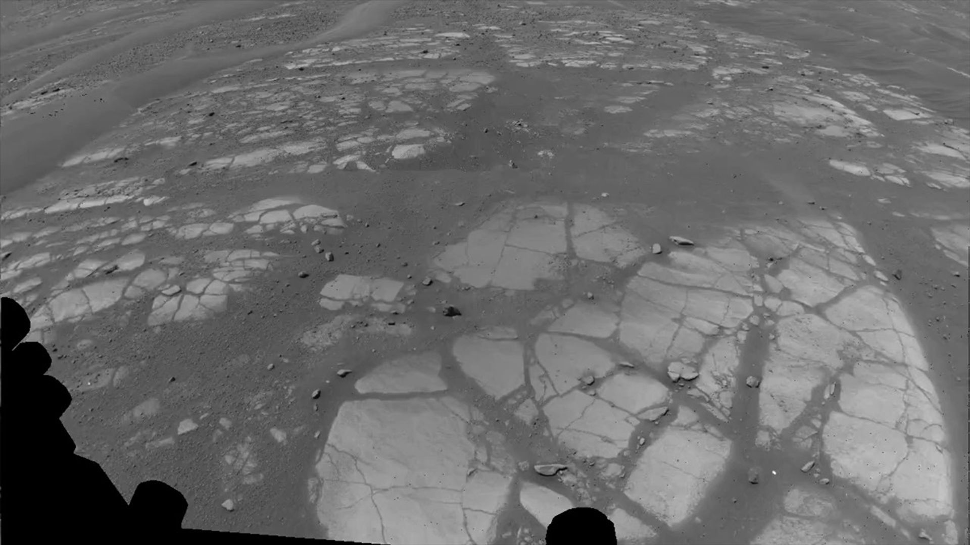
This animation shows Perseverance’s point of view during drive of 807 feet (246 meters) along the rim of Jezero Crater on Dec. 10, 2025, the 1,709th Martian day, or sol, of the mission. Captured over two hours and 35 minutes, 53 Navigation Camera (Navcam) image pairs were combined with rover data on orientation, wheel speed, and steering angle, as well as data from Perseverance’s Inertial Measurement Unit, and placed into a 3D virtual environment. The result is this reconstruction with virtual frames inserted about every 4 inches (0.1 meters) of drive progress.
NASA’s Jet Propulsion Laboratory, which is managed for the agency by Caltech, built and manages operations of the Perseverance rover.
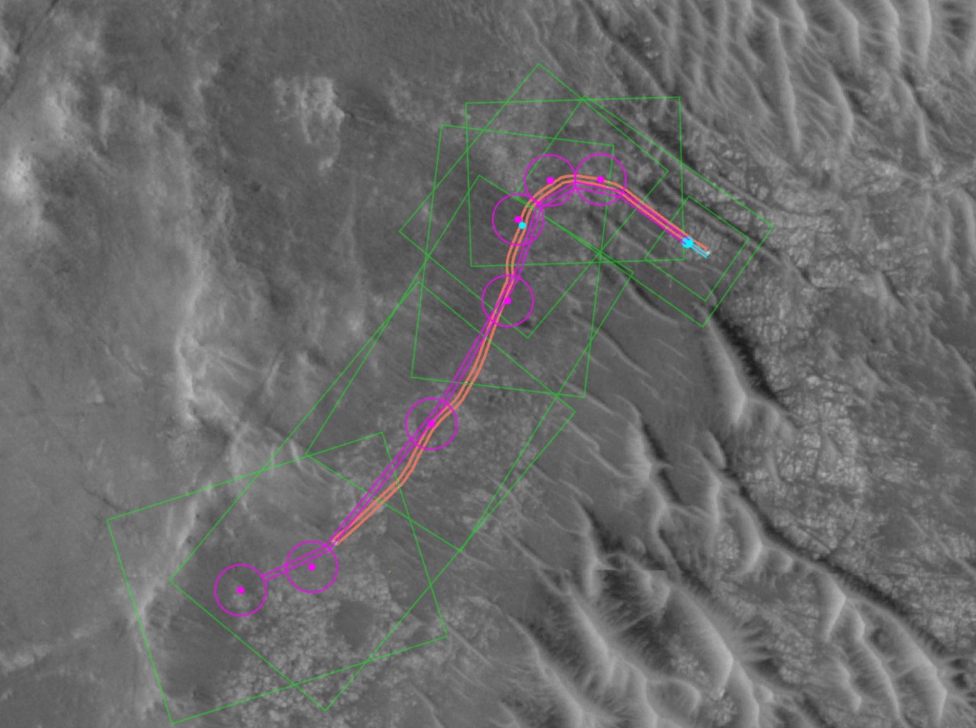
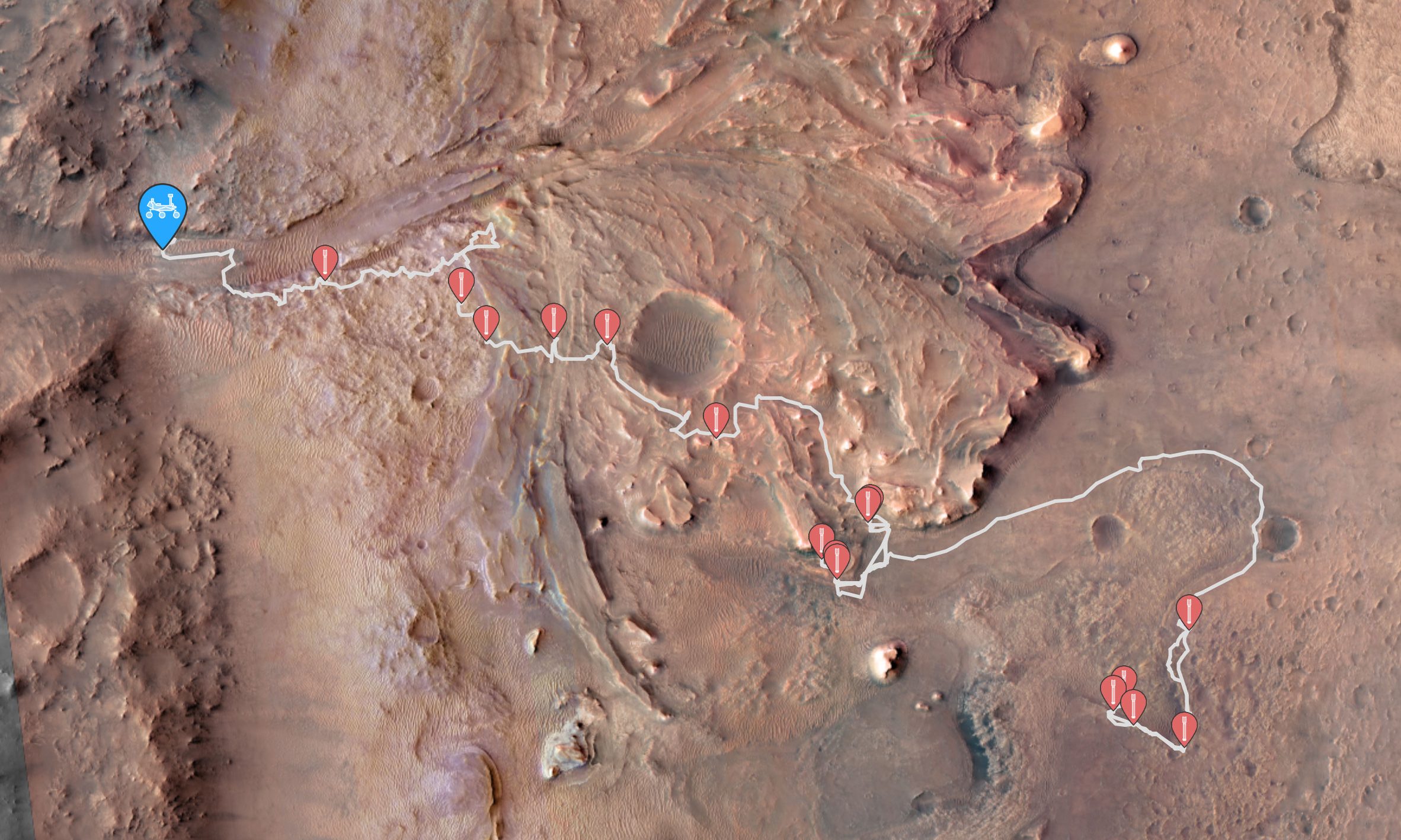
This annotated image from NASA’s HiRISE (High Resolution Imaging Science Experiment) camera aboard the agency’s Mars Reconnaissance Orbiter image depicts the AI-planned route and the actual route taken by NASA’s Perseverance Mars rover during its 807-foot (246-meter) drive on Dec. 10, 2025, the 1,709th Martian day, or sol, of the mission. The drive was the second of two demonstrations — the first being on Dec. 8 — showing that generative artificial intelligence could be incorporated in the rover’s route planning.
The magenta lines depict the path the rover’s wheels would take if it were to follow AI-processed waypoints, which are indicated with the magenta circles. (Waypoints are fixed locations where the rover takes up a new set of instructions.) The orange lines are based on data downlinked after the drive was complete and depict the actual path the rover took. The short, bold segments of the blue lines at the start of the route, in the upper right, show the portion of the drive that was determined by the mission’s rover drivers and based on imagery taken by the rover of the surface ahead. The surface areas in pale green boxes are called “keep-in zones.” Perseverance’s self-driving software is only allowed to pick routes inside those zones.
The graphic was generated using Hyperdrive, part of the software suite used to plan rover drives and manage the massive influx of engineering data from the Perseverance rover.
NASA’s Jet Propulsion Laboratory, which is managed for the agency by Caltech, built and manages operations of the Perseverance rover.
The University of Arizona in Tucson, operates HiRISE, which was built by BAE Systems in Boulder, Colorado. JPL manages the Mars Reconnaissance Orbiter for SMD.
NASA’s Commercial Satellite Data Acquisition Program Releases Archived and Tasked Multispectral Data from Satellogic
3 min read
NASA’s Commercial Satellite Data Acquisition Program Releases Archived and Tasked Multispectral Data from Satellogic
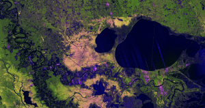
This image of an urban area outside of New Orleans, Louisiana, shows the high resolution available from Satellogic’s level 1D Orthorectified multispectral archive and tasked data product now available in the CSDA Program’s Satellite Data Explorer.
Credit: CSDA
“The mission of the CSDA Program is to identify, evaluate, and acquire data from commercial sources that support NASA’s Earth science research and application goals,” said CSDA Project Manager Dana Ostrenga. “The addition of this product from Satellogic to the SDX demonstrates the CSDA Program’s ongoing commitment to that mission, as well as to our objective of bringing high-quality, Earth observation data from NASA’s commercial partners to the Earth Science community.”
This Level 1D product, which is equivalent to a NASA-defined Level 1C data product, is derived from satellites in Satellogic’s NewSat constellation, each of which carries a multispectral camera offering four bands in visible (red, green, and blue) and near-infrared part of the electromagnetic spectrum. The product provides images covering 25,000 square kilometers (km2) of the Satellogic archive.
Researchers interested in accessing this data product in SDX can use theirEarthdata Login for authentication and initiate data download requests. The product includes all associated metadata and documentation, and its use is governed by the United States government plus End User License Agreement (USG EULA)
About SDX
The SDX allows users to search, discover, and access a variety of Global Navigation Satellite System (GNSS), digital elevation model (DEM), synthetic aperture radar (SAR), multispectral, and precipitation radar data acquired through the CSDA program. It also provides streamlined data download, automated quota tracking, and a new coverage map that provides a high-level overview of the spatial coverage of the data discoverable through the SDX for any specified month and year. For a summary of the NASA commercial partner datasets available in SDX, visit the SDX website.
To order data from SDX, users must create an account with and be logged in to NASA Earthdata. (The initial attempt to use SDX will redirect users to Earthdata Login, where they will be prompted to enter their Earthdata credentials and accept the terms of the EULA.) Users must agree to the terms of the EULA before any data can be requested. Note: All data requests must be approved by CSDA data managers.
About the CSDA Program
NASA’s Earth Science Division (ESD) established the CSDA Program to identify, evaluate, and acquire data from commercial providers that to support NASA’s Earth science research and applications. NASA recognizes the potential of commercial satellite constellations to advance Earth System Science and applications for societal benefit and believes commercially acquired data may also can augment the Earth observations acquired by NASA, and other U.S. government agencies, and NASA’s international partners.
All data from CSDA contract-awarded vendors are evaluated by the investigator-led CSDA project teams that assess the value of adding a vendor’s data to CSDA’s data holdings based on their quality and how they might benefit in the context of NASA Earth science research and applications. To learn more about the program, its commercial partners, data evaluation process, and more, visit the CSDA website.
NASA’s Perseverance Rover Completes First AI-Planned Drive on Mars
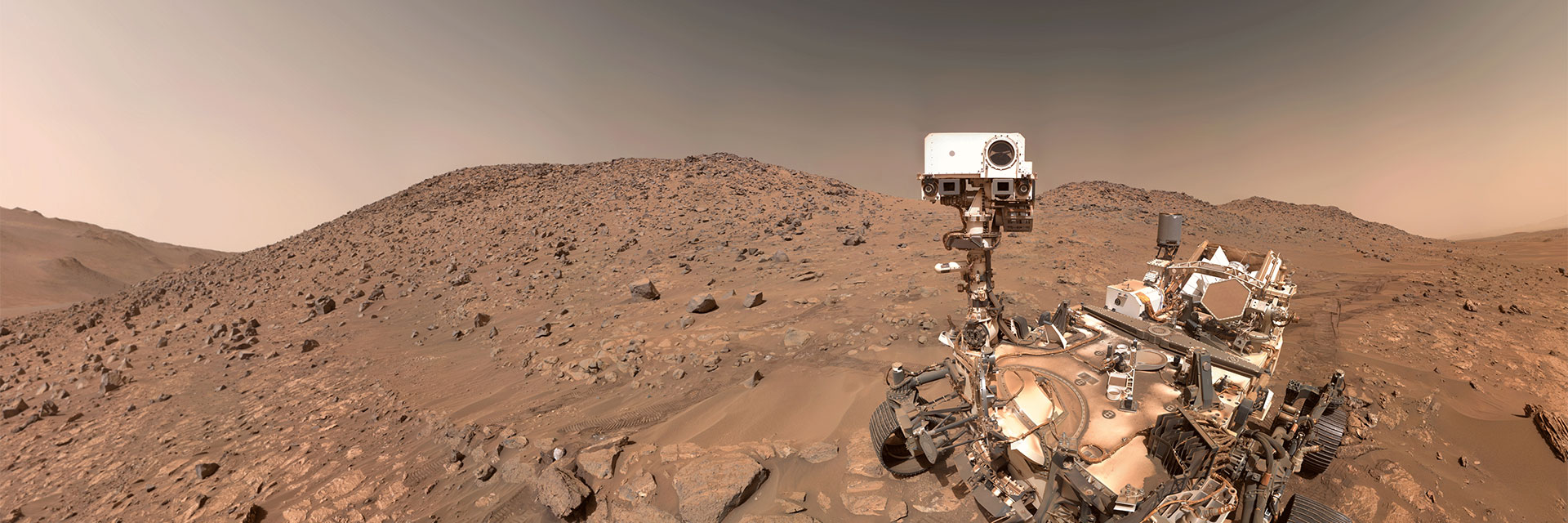
NASA’s Perseverance used its navigation cameras to capture its drive along the rim of Jezero Crater on Dec. 10, 2025. The navcam images were combined with rover data and placed into a 3D virtual environment, resulting in this reconstruction with virtual frames inserted about every 4 inches (0.1 meters) of drive progress. NASA/JPL-Caltech
The team for the six-wheeled scientist used a vision-capable AI to create a safe route over the Red Planet’s surface without the input of human route planners.
NASA’s Perseverance Mars rover has completed the first drives on another world that were planned by artificial intelligence. Executed on Dec. 8 and 10, and led by the agency’s Jet Propulsion Laboratory in Southern California, the demonstration used generative AI to create waypoints for Perseverance, a complex decision-making task typically performed manually by the mission’s human rover planners.
“This demonstration shows how far our capabilities have advanced and broadens how we will explore other worlds,” said NASA Administrator Jared Isaacman. “Autonomous technologies like this can help missions to operate more efficiently, respond to challenging terrain, and increase science return as distance from Earth grows. It’s a strong example of teams applying new technology carefully and responsibly in real operations.”
During the demonstration, the team leveraged a type of generative AI called vision-language models to analyze existing data from JPL’s surface mission dataset. The AI used the same imagery and data that human planners rely on to generate waypoints — fixed locations where the rover takes up a new set of instructions — so that Perseverance could safely navigate the challenging Martian terrain.
The initiative was led out of JPL’s Rover Operations Center (ROC) in collaboration with Anthropic, using the company’s Claude AI models.
This animation was created using data acquired during Perseverance’s Dec. 10, 2025, drive on Jezero Crater’s rim. Pale blue lines depict the track the rover’s wheels take. Black lines snaking out in front of the rover show the path options the rover is considering. The white terrain is a height map based on rover data. The blue circle that appears near the end of the animation is a waypoint. NASA/JPL-Caltech
Progress for Mars, beyond
Mars is on average about 140 million miles (225 million kilometers) away from Earth. This vast distance creates a significant communication lag, making real-time remote operation — or “joy-sticking” — of a rover impossible. Instead, for the past 28 years, over several missions, rover routes have been planned and executed by human “drivers,” who analyze the terrain and status data to sketch a route using waypoints, which are usually spaced no more than 330 feet (100 meters) apart to avoid any potential hazards. Then they send the plans via NASA’s Deep Space Network to the rover, which executes them.
But for Perseverance’s drives on the 1,707 and 1,709 Martian days, or sols, of the mission, the team did something different: Generative AI provided the analysis of the high-resolution orbital imagery from the HiRISE (High Resolution Imaging Science Experiment) camera aboard NASA’s Mars Reconnaissance Orbiter and terrain-slope data from digital elevation models. After identifying critical terrain features — bedrock, outcrops, hazardous boulder fields, sand ripples, and the like — it generated a continuous path complete with waypoints.
To ensure the AI’s instructions were fully compatible with the rover’s flight software, the engineering team also processed the drive commands through JPL’s “digital twin” (virtual replica of the rover), verifying over 500,000 telemetry variables before sending commands to Mars.
On Dec. 8, with generative AI waypoints in its memory, Perseverance drove 689 feet (210 meters). Two days later, it drove 807 feet (246 meters).
“The fundamental elements of generative AI are showing a lot of promise in streamlining the pillars of autonomous navigation for off-planet driving: perception (seeing the rocks and ripples), localization (knowing where we are), and planning and control (deciding and executing the safest path),” said Vandi Verma, a space roboticist at JPL and a member of the Perseverance engineering team. “We are moving towards a day where generative AI and other smart tools will help our surface rovers handle kilometer-scale drives while minimizing operator workload, and flag interesting surface features for our science team by scouring huge volumes of rover images.”
“Imagine intelligent systems not only on the ground at Earth, but also in edge applications in our rovers, helicopters, drones, and other surface elements trained with the collective wisdom of our NASA engineers, scientists, and astronauts,” said Matt Wallace, manager of JPL’s Exploration Systems Office. “That is the game-changing technology we need to establish the infrastructure and systems required for a permanent human presence on the Moon and take the U.S. to Mars and beyond.”
This annotated orbital image depicts the AI-planned (depicted in magenta) and actual (orange) routes the Perseverance Mars rover took during its Dec. 10, 2025, drive at Jezero Crater. The drive was the second of two demonstrations showing that generative AI could be incorporated into rover route planning.
NASA/JPL-Caltech/UofA
More about Perseverance
Managed for NASA by Caltech, JPL is home to the Rover Operations Center (ROC). It also manages operations of the Perseverance rover on behalf of the agency’s Science Mission Directorate as part of NASA’s Mars Exploration Program portfolio.
What’s Up: February 2026 Skywatching Tips from NASA
The Moon readies for Artemis II, Orion shines bright, and a planetary parade marches across the night sky
NASA’s Artemis II mission has its first opportunity to launch to the moon, Orion the Hunter takes center stage, and a planetary parade marches across the night sky.
Skywatching Highlights
Feb: Artemis II launch window opens.
Feb: Orion the Hunter ideal viewing
Mid-Late Feb: Planetary Parade
Transcript
The Moon could have human visitors for the first time since 1972, the constellation Orion will be clear to see, and a planetary parade will sparkle across the skies.
That’s What’s Up, this February.
The Moon could have some visitors soon!
NASA’s Artemis II mission will send astronauts to fly around the Moon. The first opportunities for launch are this February.
This mission will pave the way for Artemis III, which will be the first time we’ve sent humans to the lunar surface since the final Apollo mission, Apollo 17, in 1972.
So this month, look up to the Moon shining bright in the night sky and there might be somebody looking back down at you.
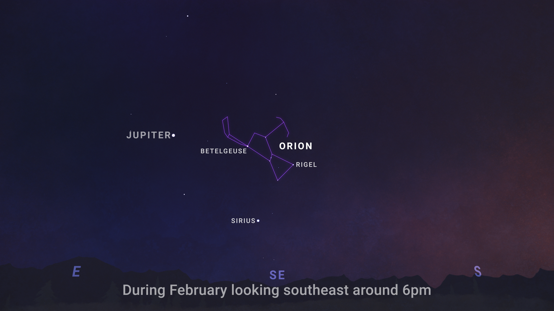
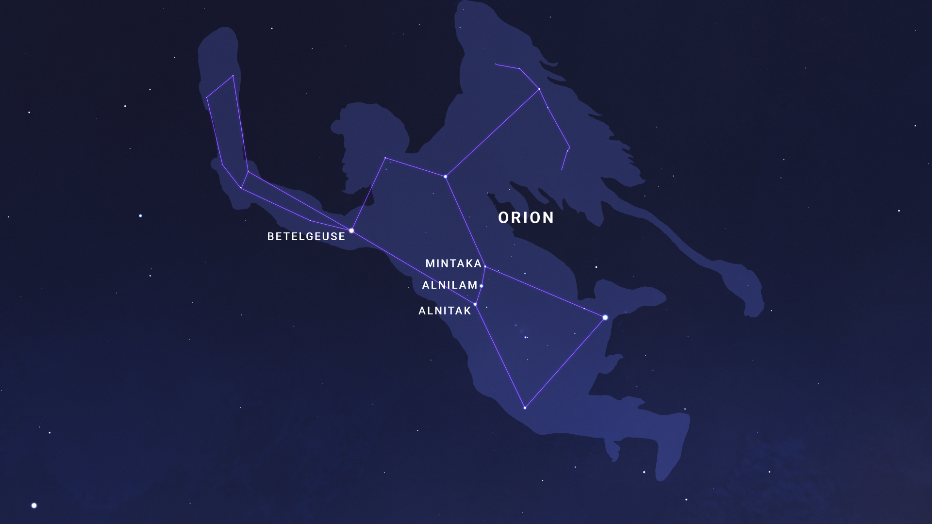
Can you spot Orion the Hunter in the night sky?
NASA/JPL-Caltech
You might be able to see the line of three stars that make up Orion’s Belt, but that belt is a part of a larger constellation called Orion, named for the hunter in Greek mythology.
Above Orion’s belt, the hunter’s right shoulder is actually Betelgeuse (or Alpha Orionis), one of the brightest stars in the night sky!
NASA/JPL-Caltech
Most visible in the winter, February is one of the clearest times to see Orion in the sky.
From dusk through the night, look to the southern sky and try and spot the hunter for yourself.
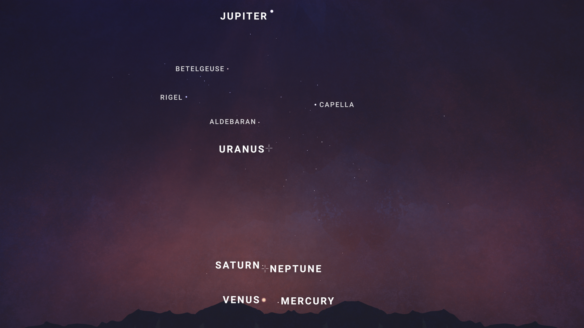
A planetary parade will march across the sky this month!
NASA/JPL-Caltech
Mid-February, Saturn will drop down toward the horizon as Venus and Mercury climb upward in the sky, meeting together in the west to southwestern sky.
Jupiter will find itself high in the sky.
And even Uranus, found in the southern sky, and Neptune, found nearby Saturn, will join the parade—though you’ll need binoculars or a telescope to spot these two far-off planets.
The planets will be visible soon after sunset throughout the month of February, but they’ll be lined up best toward the end of the month.
So, go outside and see how many planets you can find!
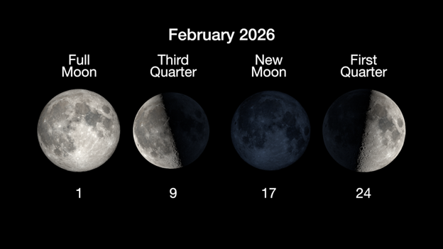
Here are the phases of the Moon for February.
NASA/JPL-Caltech
You can stay up to date on all of NASA’s missions exploring the solar system and beyond at science.nasa.gov.
I’m Chelsea Gohd from NASA’s Jet Propulsion Laboratory, and that’s What’s Up for this month.