Atmospheric Probe Shows Promise in Test Flight

Atmospheric Probe Shows Promise in Test Flight

3 min read

Preparations for Next Moonwalk Simulations Underway (and Underwater)

NASA/Steve Parcel

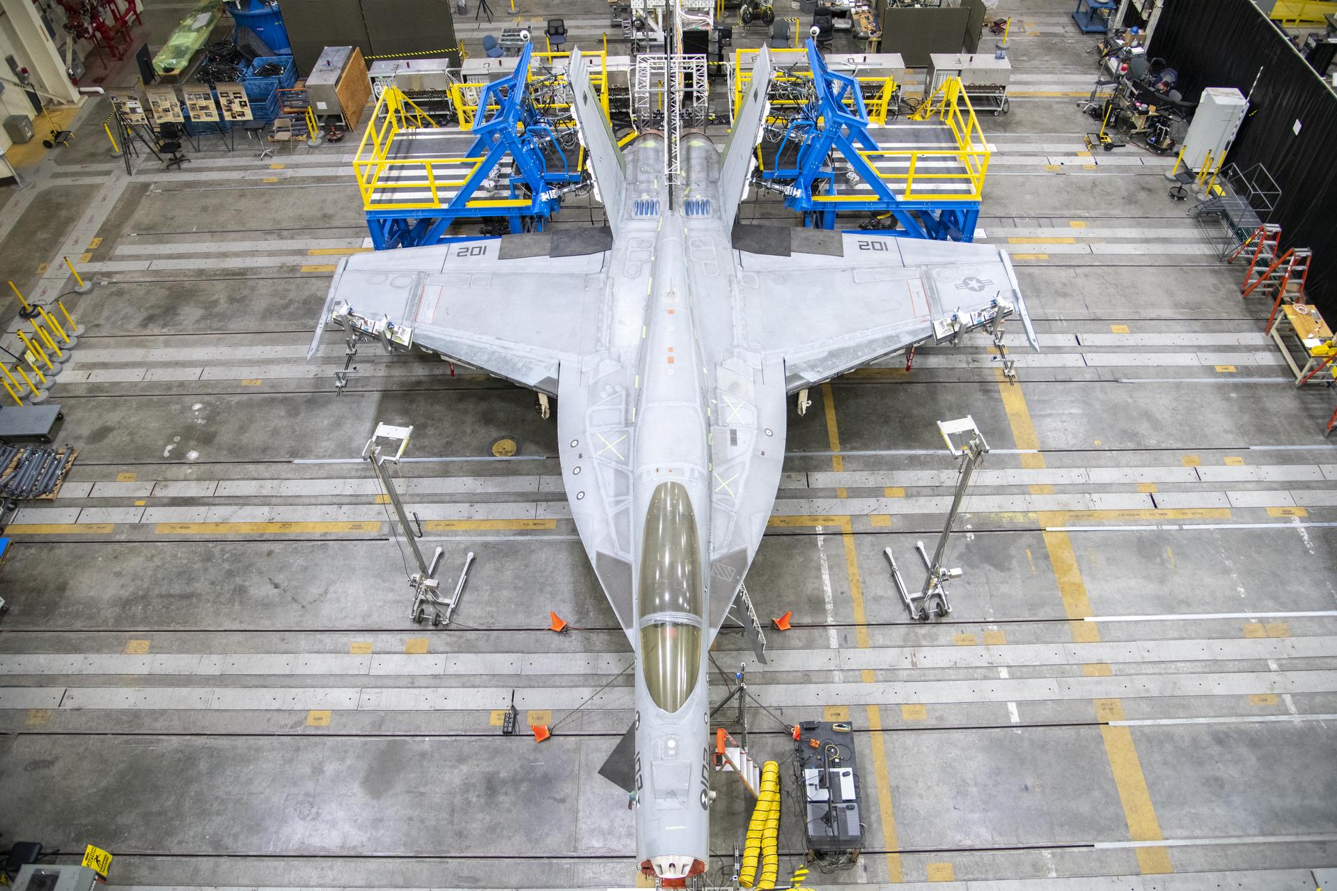
The most effective way to prove a new idea is to start small, test, learn, and test again. A team of researchers developing an atmospheric probe at NASA’s Armstrong Flight Research Center in Edwards, California, are taking that approach. The concept could offer future scientists a potentially better and more economical way to collect data on other planets.

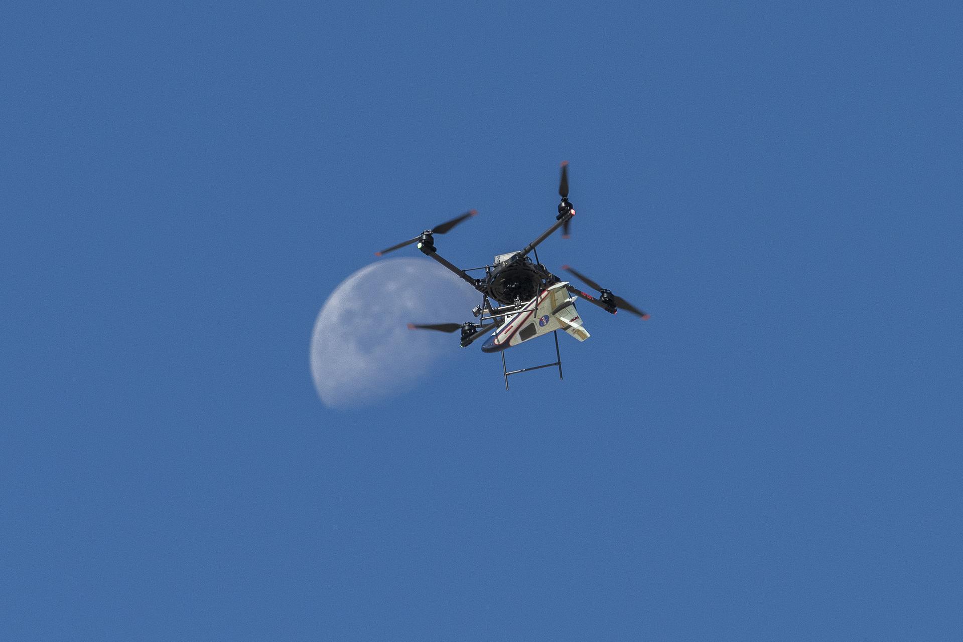
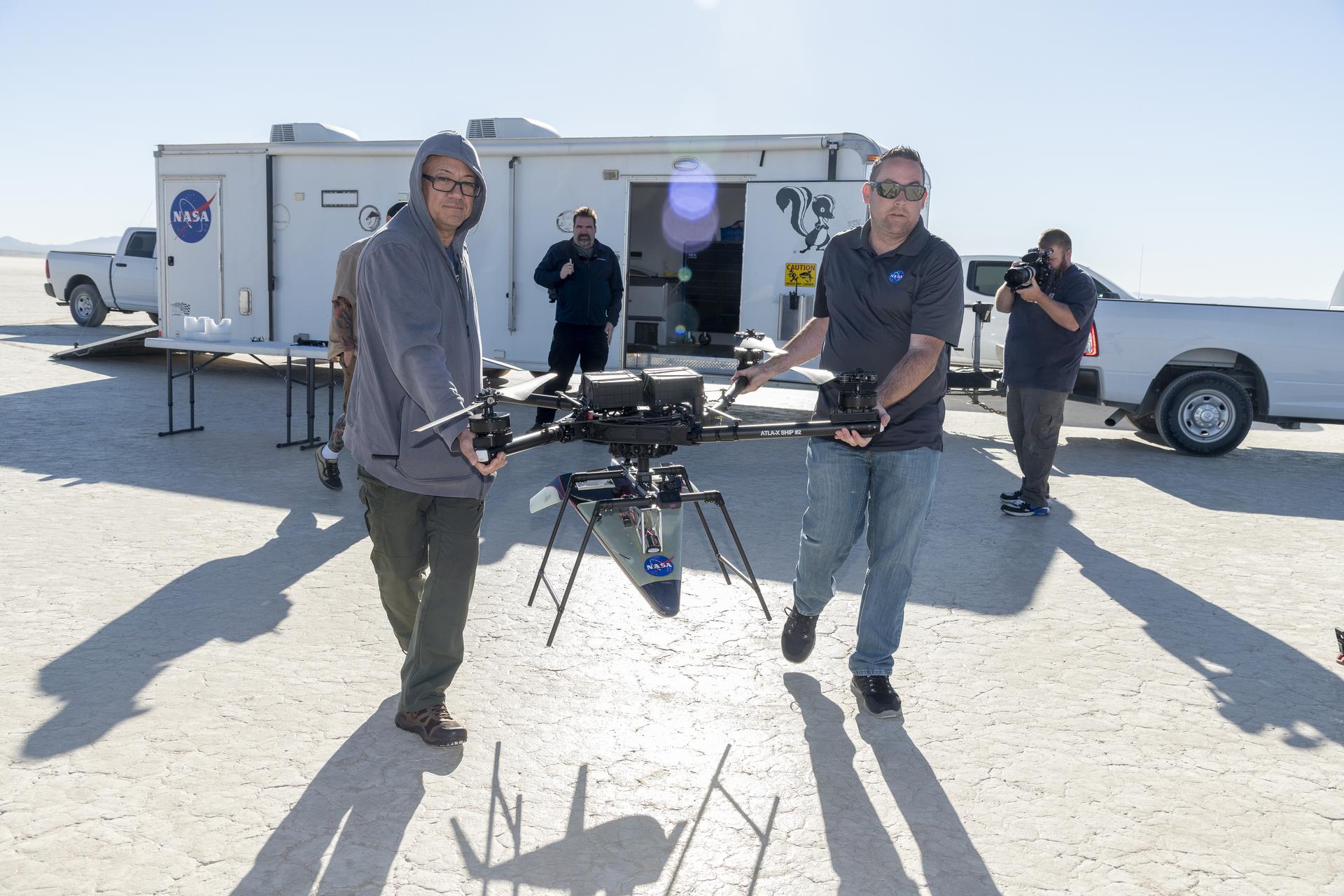
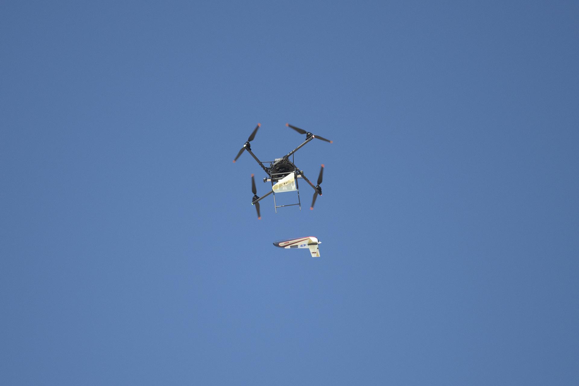
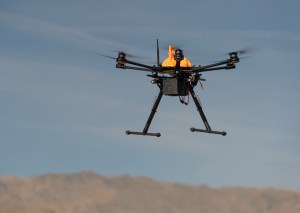
The latest iteration of the atmospheric probe flew after release from a quad-rotor remotely piloted aircraft on Oct. 22 above Rogers Dry Lake, a flight area adjacent to NASA Armstrong. The probe benefits from NASA 1960s research on lifting body aircraft, which use the aircraft’s shape for lift instead of wings. Testing demonstrated the shape of the probe works.

“I’m ecstatic,” said John Bodylski, atmospheric probe principal investigator at NASA Armstrong. “It was completely stable in flight. We will be looking at releasing it from a higher altitude to keep it flying longer and demonstrate more maneuvers.”

An atmospheric probe model carried by a quad rotor aircraft rises and the Moon is visible.
An atmospheric probe model attached upside down to a quad rotor remotely piloted aircraft ascends with the Moon visible on Oct. 22, 2024. The quad rotor aircraft released the probe above Rogers Dry Lake, a flight area adjacent NASA’s Armstrong Flight Research Center in Edwards, California. The probe was designed and built at the center.
NASA/Steve Freeman

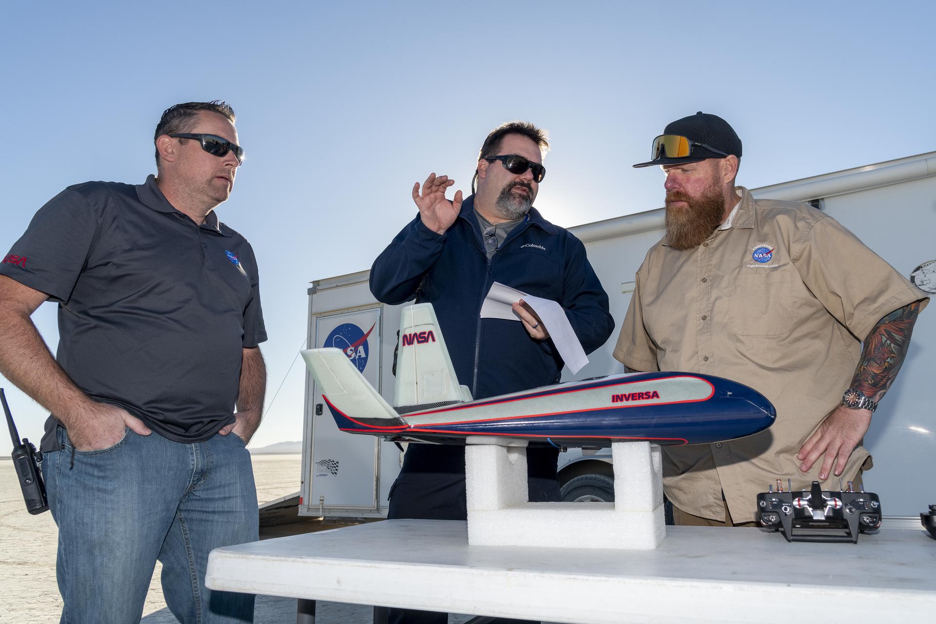
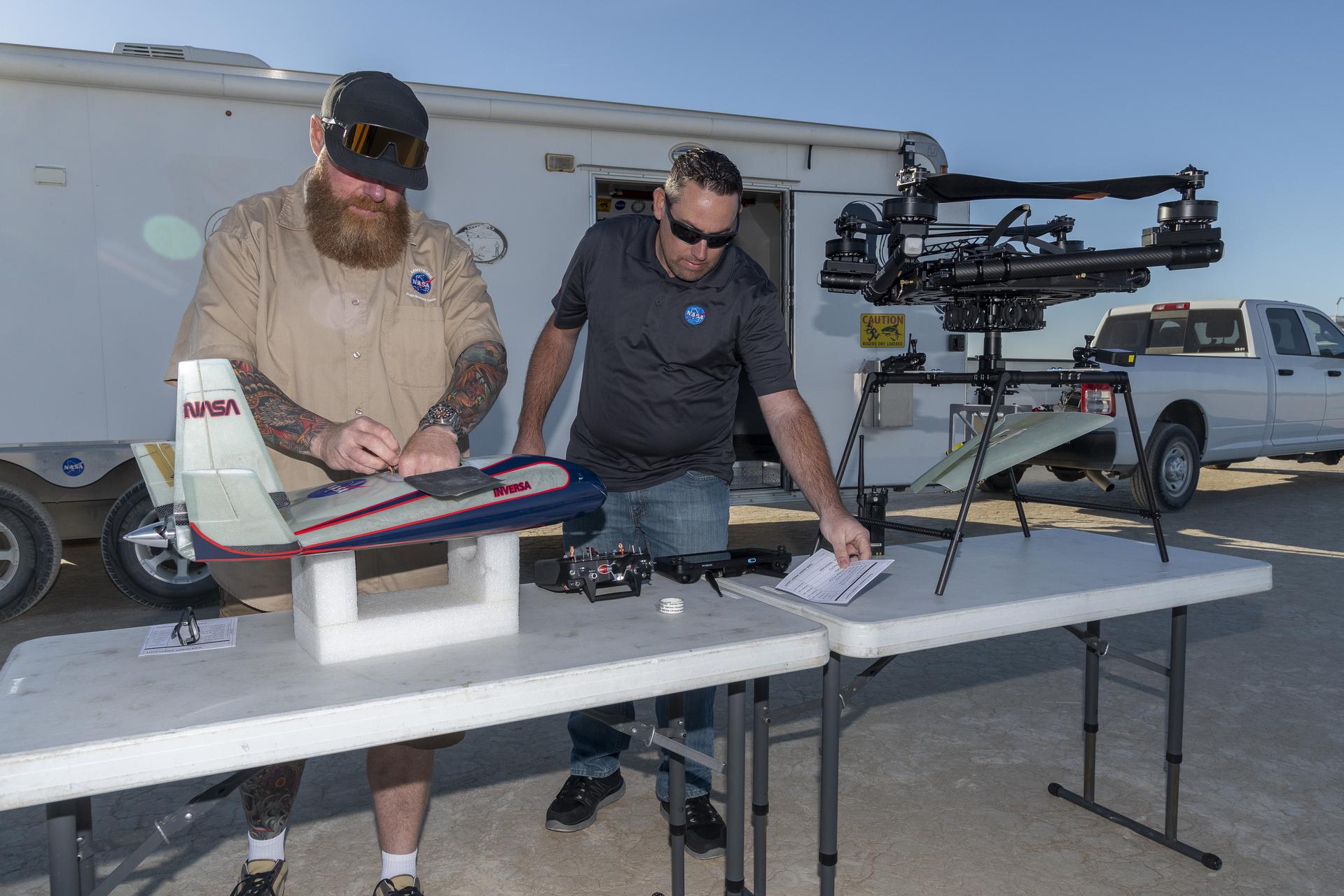
Starting with a Center Innovation Fund award in 2023, Bodylski worked closely with the center’s Dale Reed Subscale Flight Research Laboratory to design and build three atmospheric probe models, each vehicle 28 inches long from nose to tail. One model is a visual to show what the concept looks like, while two additional prototypes improved the technology’s readiness.

The road to the successful flight wasn’t smooth, which is expected with any new flight idea. The first flight on Aug. 1 didn’t go as planned. The release mechanism didn’t work as expected and air movement from the quad rotor aircraft was greater than anticipated. It was that failure that inspired the research team to take another look at everything about the vehicle, leading to many improvements, said Justin Hall, NASA Armstrong chief pilot of small, unmanned aircraft systems.

Fast forward to Oct. 22, where the redesign of the release mechanism, in addition to an upside-down release and modified flight control surfaces, led to a stable and level flight. “Everything we learned from the first vehicle failing and integrating what we learned into this one seemed to work well,” Hall said. “This is a win for us. We have a good place to go from here and there’s some more changes we can make to improve it.”

Three men talk with a model probe on the table in front of them.
Justin Link, left, small unmanned aircraft systems pilot; John Bodylski, atmospheric probe principal investigator; and Justin Hall, chief pilot of small unmanned aircraft systems, discuss details of the atmospheric probe flight plan on Oct. 22, 2024. A quad rotor remotely piloted aircraft released the probe above Rogers Dry Lake, a flight area adjacent NASA’s Armstrong Flight Research Center in Edwards, California. The probe was designed and built at the center.
NASA/Steve Freeman

Bodylski added, “We are going to focus on getting the aircraft to pull up sooner to give us more flight time to learn more about the prototype. We will go to a higher altitude [this flight started at 560 feet altitude] on the next flight because we are not worried about the aircraft’s stability.”

When the team reviewed flight photos and video from the Oct. 22 flight they identified additional areas for improvement. Another atmospheric probe will be built with enhancements and flown. Following another successful flight, the team plans to instrument a future atmospheric probe that will gather data and improve computer models. Data gathering is the main goal for the current flights to give scientists confidence in additional probe shapes for atmospheric missions on other planets.

If this concept is eventually chosen for a mission, it would ride on a satellite to its destination. From there, the probe would separate as the parent satellite orbits around a planet, then enter and dive through the atmosphere as it gathers information for clues of how the solar system formed.

Two men prepare an atmospheric probe model for flight.
Justin Hall, chief pilot of small unmanned aircraft systems, prepares the atmospheric probe for flight above Rogers Dry Lake, a flight area adjacent NASA’s Armstrong Flight Research Center in Edwards, California. At right, Justin Link, small unmanned aircraft systems pilot, assists. The probe, designed and built at the center, flew after release from a quad rotor remotely piloted aircraft on Oct. 22, 2024.
NASA/Steve Freeman
Two men prepare an aircraft model for flight.
Derek Abramson, left, chief engineer for the Dale Reed Subscale Flight Research Laboratory, and Justin Link, small unmanned aircraft system pilot, carry the atmospheric probe model and a quad rotor remotely piloted aircraft to position it for flight on Oct. 24, 2024. John Bodylski, probe principal investigator, right, and videographer Jacob Shaw watch the preparations. Once at altitude, the quad rotor aircraft released the probe above Rogers Dry Lake, a flight area adjacent to NASA’s Armstrong Flight Research Center in Edwards, California. The probe was designed and built at the center.
NASA/Steve Freeman
A quad rotor remotely piloted aircraft releases an atmospheric probe model in flight.
A quad rotor remotely piloted aircraft releases the atmospheric probe model above Rogers Dry Lake, a flight area adjacent NASA’s Armstrong Flight Research Center in Edwards, California, on Oct. 22, 2024. The probe was designed and built at the center.
NASA/Carla Thomas

Powered by WPeMatico

Get The Details…
Dede Dinius

NASA-DOD Study: Saltwater to Widely Taint Coastal Groundwater by 2100

NASA-DOD Study: Saltwater to Widely Taint Coastal Groundwater by 2100

5 min read

Preparations for Next Moonwalk Simulations Underway (and Underwater)

Watersheds on the U.S. Eastern Seaboard
Watersheds on the U.S. Eastern Seaboard will be among the areas most affected by underground saltwater intrusion by the year 2100 due to sea level rise and changes in groundwater supplies, according to a NASA-DOD study. NASA’s Terra satellite captured this image on April 21, 2023.
NASA

Intrusion of saltwater into coastal groundwater can make water there unusable, damage ecosystems, and corrode infrastructure.

Seawater will infiltrate underground freshwater supplies in about three of every four coastal areas around the world by the year 2100, according to a recent study led by researchers at NASA’s Jet Propulsion Laboratory in Southern California. In addition to making water in some coastal aquifers undrinkable and unusable for irrigation, these changes can harm ecosystems and corrode infrastructure.

Called saltwater intrusion, the phenomenon happens below coastlines, where two masses of water naturally hold each other at bay. Rainfall on land replenishes, or recharges, fresh water in coastal aquifers (underground rock and soil that hold water), which tends to flow below ground toward the ocean. Meanwhile, seawater, backed by the pressure of the ocean, tends to push inland. Although there’s some mixing in the transition zone where the two meet, the balance of opposing forces typically keeps the water fresh on one side and salty on the other.

Now, two impacts of climate change are tipping the scales in favor of salt water. Spurred by planetary warming, sea level rise is causing coastlines to migrate inland and increasing the force pushing salt water landward. At the same time, slower groundwater recharge — due to less rainfall and warmer weather patterns — is weakening the force moving the underground fresh water in some areas.

Worldwide Intrusion

NASA-DOD study estimate map
Saltwater intrusion will affect groundwater in about three of every four coastal aquifers around the world by the year 2100, a NASA-DOD study estimates. Saltwater can make groundwater in coastal areas undrinkable and useless for irrigation, as well as harm ecosystems and corrode infrastructure.
NASA/JPL-Caltech

The study, published in Geophysical Research Letters in November, evaluated more than 60,000 coastal watersheds (land area that channels and drains all the rainfall and snowmelt from a region into a common outlet) around the world, mapping how diminished groundwater recharge and sea level rise will each contribute to saltwater intrusion while estimating what their net effect will be.

Considering the two factors separately, the study’s authors found that by 2100 rising sea levels alone will tend to drive saltwater inland in 82% of coastal watersheds studied. The transition zone in those places would move a relatively modest distance: no more than 656 feet (200 meters) from current positions. Vulnerable areas include low-lying regions such as Southeast Asia, the coast around the Gulf of Mexico, and much of the United States’ Eastern Seaboard.  

Meanwhile, slower recharge on its own will tend to cause saltwater intrusion in 45% of the coastal watersheds studied. In these areas, the transition zone would move farther inland than it will from sea level rise — as much as three-quarters of a mile (about 1,200 meters) in some places. The regions to be most affected include the Arabian Peninsula, Western Australia, and Mexico’s Baja California peninsula. In about 42% of coastal watersheds, groundwater recharge will increase, tending to push the transition zone toward the ocean and in some areas overcoming the effect of saltwater intrusion by sea level rise.

All told, due to the combined effects of changes in sea level and groundwater recharge, saltwater intrusion will occur by century’s end in 77% of the coastal watersheds evaluated, according to the study.

Generally, lower rates of groundwater recharge are going to drive how far saltwater intrudes inland, while sea level rise will determine how widespread it is around the world. “Depending on where you are and which one dominates, your management implications might change,” said Kyra Adams, a groundwater scientist at JPL and the paper’s lead author. 

For example, if low recharge is the main reason intrusion is happening in one area, officials there might address it by protecting groundwater resources, she said. On the other hand, if the greater concern is that sea level rise will oversaturate an aquifer, officials might divert groundwater.

Global Consistency

Co-funded by NASA and the U.S. Department of Defense (DOD), the study is part of an effort to evaluate how sea level rise will affect the department’s coastal facilities and other infrastructure. It used information on watersheds collected in HydroSHEDS, a database managed by the World Wildlife Fund that uses elevation observations from the NASA Shuttle Radar Topography Mission. To estimate saltwater intrusion distances by 2100, the researchers used a model accounting for groundwater recharge, water table rise, fresh- and saltwater densities, and coastal migration from sea level rise, among other variables.

Study coauthor Ben Hamlington, a climate scientist at JPL and a coleader of NASA’s Sea Level Change Team, said that the global picture is analogous to what researchers see with coastal flooding: “As sea levels rise, there’s an increased risk of flooding everywhere. With saltwater intrusion, we’re seeing that sea level rise is raising the baseline risk for changes in groundwater recharge to become a serious factor.”

A globally consistent framework that captures localized climate impacts is crucial for countries that don’t have the expertise to generate one on their own, he added.

“Those that have the fewest resources are the ones most affected by sea level rise and climate change,” Hamlington said, “so this kind of approach can go a long way.”

News Media Contacts

Andrew Wang / Jane J. Lee
Jet Propulsion Laboratory, Pasadena, Calif.
626-379-6874 / 818-354-0307
andrew.wang@jpl.nasa.gov / jane.j.lee@jpl.nasa.gov 

Powered by WPeMatico

Get The Details…
Anthony Greicius

NASA Study: Crops, Forests Responding to Changing Rainfall Patterns

NASA Study: Crops, Forests Responding to Changing Rainfall Patterns

4 min read

NASA Study: Crops, Forests Responding to Changing Rainfall Patterns

Light and dark blue splotches cover Earth as a yellow band streaks across the Pacific Ocean between Central America and Indonesia.
Earth’s rainy days are changing and plant life is responding. This visualization shows average precipitation for the entire globe based on more than 20 years of data from 2000 to 2023. Cooler colors indicate areas that receive less rain. Warm colors receive more rain.
NASA’s Scientific Visualization Studio

A new NASA-led study has found that how rain falls in a given year is nearly as important to the world’s vegetation as how much. Reporting Dec. 11 in Nature, the researchers showed that even in years with similar rainfall totals, plants fared differently when that water came in fewer, bigger bursts. 

In years with less frequent but more concentrated rainfall, plants in drier environments like the U.S. Southwest were more likely to thrive. In humid ecosystems like the Central American rainforest, vegetation tended to fare worse, possibly because it could not tolerate the longer dry spells.

Scientists have previously estimated that almost half of the world’s vegetation is driven primarily by how much rain falls in a year. Less well understood is the role of day-to-day variability, said lead author Andrew Feldman, a hydrologist and ecosystem scientist at NASA’s Goddard Space Flight Center in Greenbelt, Maryland. Shifting precipitation patterns are producing stronger rainstorms — with longer dry spells in between — compared to a century ago.

“You can think of it like this: if you have a house plant, what happens if you give it a full pitcher of water on Sunday versus a third of a pitcher on Monday, Wednesday, and Friday?” said Feldman. Scale that to the size of the U.S. Corn Belt or a rainforest and the answer could have implications for crop yields and ultimately how much carbon dioxide plants remove from the atmosphere.

Blooms in Desert

The team, including researchers from the U.S. Department of Agriculture and multiple universities, analyzed two decades of field and satellite observations, spanning millions of square miles. Their study area encompassed diverse landscapes from Siberia to the southern tip of Patagonia.

Bright yellow and orange flowers dot a green, hilly landscape beneath a light blue sky.
Yellow wildflowers and orange poppies carpet the desert following a wet winter for the Antelope Valley in California.
NASA/Jim Ross

They found that plants across 42% of Earth’s vegetated land surface were sensitive to daily rainfall variability. Of those, a little over half fared better — often showing increased growth — in years with fewer but more intense wet days. These include croplands as well as drier landscapes like grasslands and deserts.

In contrast, broadleaf (e.g., oak, maple, and beech) forests and rainforests in lower and middle latitudes tended to fare worse under those conditions. The effect was especially pronounced in Indo-Pacific rainforests, including in the Philippines and Indonesia.

Statistically, daily rainfall variability was nearly as important as annual rainfall totals in driving growth worldwide.

Red Light, Green Light

The new study relied primarily on a suite of NASA missions and datasets, including the Integrated Multi-satellitE Retrievals for GPM (IMERG) algorithm, which provides rain and snowfall rates for most of the planet every 30 minutes using a network of international satellites.

To gauge plant response day to day, the researchers calculated how green an area appeared in satellite imagery. “Greenness”, also known asthe Normalized Difference Vegetation Index, is commonly used to estimate vegetation density and health. They also tracked a faint reddish light that plants emit during photosynthesis, when a plant absorbs sunlight to convert carbon dioxide and water into food, its chlorophyll “leaks” unused photons. This faint light is called solar-induced fluorescence, and it’s a telltale sign of flourishing vegetation.

Growing plants emit a form of light detectable by NASA satellites orbiting hundreds of miles above Earth. Parts of North America appear to glimmer in this visualization, depicting an average year. Gray indicates regions with little or no fluorescence; red, pink, and white indicate high fluorescence.
NASA Scientific Visualization Studio

Not visible bythe naked eye, plant fluorescence can be detected by instruments aboard satellites such as NASA’s Orbiting Carbon Observatory-2 (OCO-2). Launched in 2014, OCO-2 has observed the U.S. Midwest fluorescing strongly during the growing season.

Feldman said the findings highlight the vital role that plants play in moving carbon around Earth — a process called the carbon cycle. Vegetation, including crops, forests, and grasslands, forms a vast carbon “sink,” absorbing excess carbon dioxide from the atmosphere.

“A finer understanding of how plants thrive or decline day to day, storm by storm, could help us better understand their role in that critical cycle,” Feldman said.

The study also included researchers from NASA’s Jet Propulsion Laboratory in Southern California, Stanford University, Columbia University, Indiana University, and the University of Arizona.

By Sally Younger
NASA’s Earth Science News Team

Powered by WPeMatico

Get The Details…

Science Photo Album Showcases Space Station Research in 2024

Science Photo Album Showcases Space Station Research in 2024

Three astronauts, all wearing black, are facing the camera and looking out a cupola window, where Earth is visible above them. Barratt, on the left, holds a handrail with his left hand and points a camera toward Earth with his right hand, squinting his left eye. Dominick, center, smiles with eyes toward the window, and O’Hara, on the right, uses both hands to point a camera with a large lens at Earth. The camera obscures her face.
NASA Astronauts (from left) Mike Barratt, Matthew Dominick, and Loral O’Hara take photographs of Earth from inside the cupola aboard space station.
Credit: NASA

That’s a wrap! Astronauts aboard the International Space Station conducted hundreds of science experiments and technology demonstrations during 2024. Crew members participated in research across a variety of scientific disciplines and accomplished milestones demonstrating benefits for future missions and humanity back on Earth. Their work included snapping thousands of images of Earth to understand our planet’s changing landscape, bioprinting cardiac tissues to validate technology for organ manufacturing in space, and studying physical phenomena that could improve drug delivery systems and technology for plant growth in reduced gravity.

This new image gallery showcases dozens of awe-inspiring photos and includes details about the research benefits of the state-of-the-art science happening aboard space station.

Discover the best science images of 2024 from your orbiting lab.

Powered by WPeMatico

Get The Details…
Andrea Lloyd

They Grow So Fast: Moon Tree Progress Since NASA’s Artemis I Mission

They Grow So Fast: Moon Tree Progress Since NASA’s Artemis I Mission

3 Min Read

They Grow So Fast: Moon Tree Progress Since NASA’s Artemis I Mission

A small Artemis Moon Tree planted in the ground with a circular marker and bordered by a fence

In the two years since NASA’s Orion spacecraft returned to Earth with more than 2,000 tree seedlings sourced in a partnership with USDA Forest Service, Artemis I Moon trees have taken root at 236 locations across the contiguous United States. Organizations are cultivating more than just trees, as they nurture community connections, spark curiosity about space, and foster a deeper understanding of NASA’s missions.

Universities, federal agencies, museums, and other organizations who were selected to be Moon tree recipients have branched out to provide their community unique engagements with their seedling.

Children sitting in a circle around a newly planted Moon tree and learning about NASA's Artemis I mission.
Children sitting in a circle around a newly planted Moon tree and learning about NASA’s Artemis I mission.
Adria Gillespie

“Through class visits to the tree, students have gained a lot of interest in caring for the tree, and their curiosity for the unknown in outer space sparked them to do research of their own to get answers to their inquiries,” said Adria Gillespie, the district science coach at Greenfield Union School District in Greenfield, California.

The presence of a Moon tree at schools has blossomed into more student engagements surrounding NASA’s missions. Along with planting their American Sycamore, students from Eagle Pointe Elementary in Plainfield, Illinois, are participating in a Lunar Quest club to learn about NASA and engage in a simulated field trip to the Moon.

Eagle Pointe Elementary students also took part in a planting ceremony for their seedling, where they buried a time capsule with the seed, and established a student committee responsible for caring for their Moon tree.

At Marshall STEMM Academy in Toledo, Ohio, second grade students were assigned reading activities associated with their Moon tree, fourth graders created Moon tree presentations to show the school, and students engaged with city leaders and school board members to provide a Moon tree dedication.

Two individuals planting a Moon tree.
Brandon Dillman

A seedling sent to The Gathering Garden in Mount Gilead, North Carolina, is cared for by community volunteers. Lessons with local schools and 4-H clubs, as well as the establishment of newsletters and social media to maintain updates, have sprouted from The Gathering Garden’s Loblolly Pine.

Sprucing Up the Moon Trees’ Environment

In addition to nurturing their Moon tree, many communities have planted other trees alongside their seedling to foster a healthier environment. In Castro Valley, California, a non-profit called ForestR planted oak, fir, and sequoia trees to nestle their seedling among a tree “family.”

New homes for additional Moon tree seedlings are being identified each season through Fall 2025. Communities continue to track how the impact of NASA’s science and innovation grows alongside their Moon trees.

NASA’s “new generation” Moon trees originally blossomed from NASA’s Apollo 14 mission, where NASA astronaut Stuart Roosa carried tree seeds into lunar orbit. NASA’s Next Generation STEM project partnered with USDA Forest Service to bring Moon trees to selected organizations. As NASA continues to work for the benefit of all, its Moon trees have demonstrated how one tiny seed can sprout positive change for communities, the environment, and education.

Learn more about NASA’s STEM engagements: https://stem.nasa.gov

Powered by WPeMatico

Get The Details…
Sandra May