SWOT Satellite Helps Gauge the Depth of Death Valley’s Temporary Lake

SWOT Satellite Helps Gauge the Depth of Death Valley’s Temporary Lake
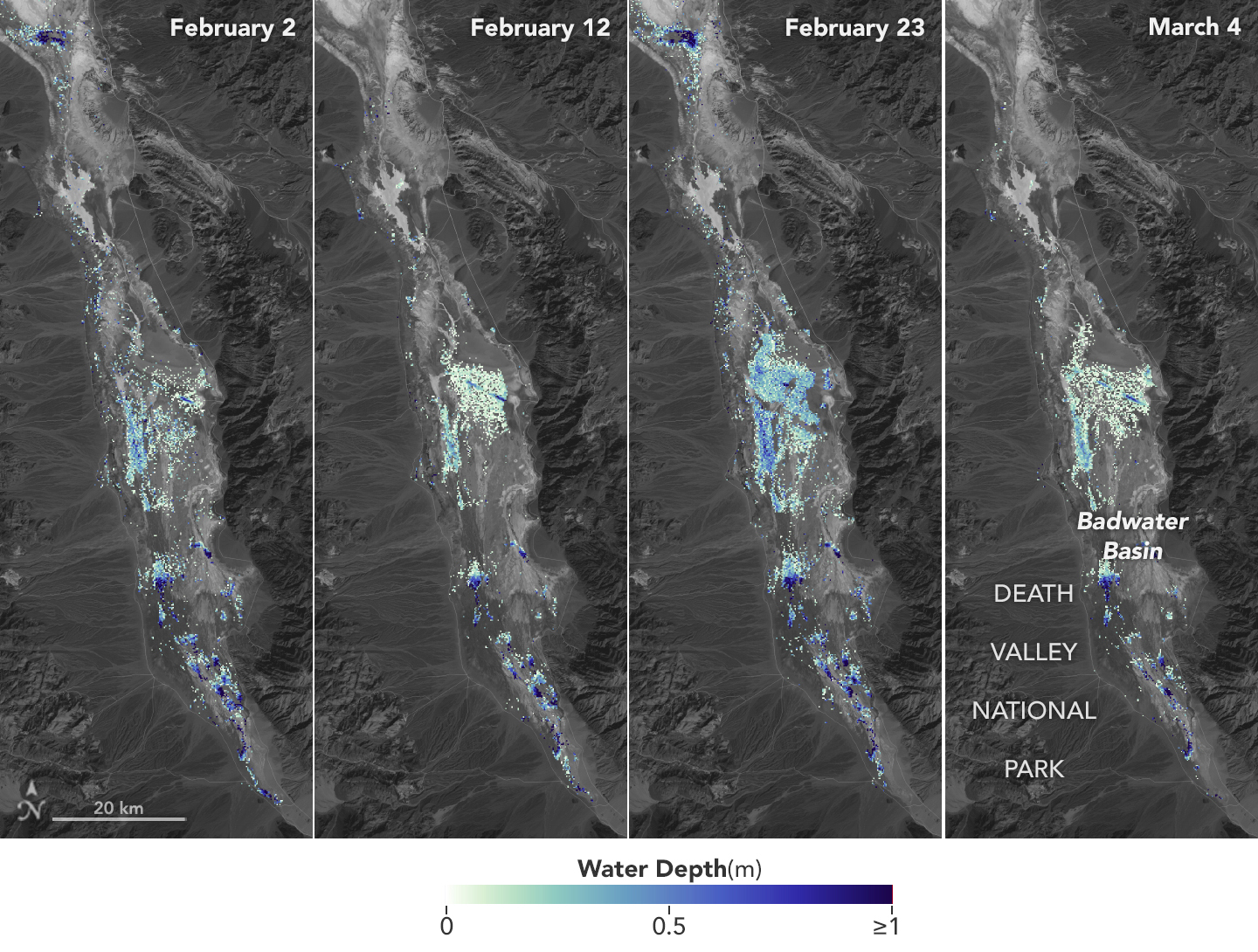
Water depths in Death Valley’s temporary lake ranged between about 3 feet (or 1 meter, shown in dark blue) to less than 1.5 feet (0.5 meters, light yellow) from February through early March. By measuring water levels from space, SWOT enabled research to calculate the depth.
NASA/JPL-Caltech

Data from the international Surface Water and Ocean Topography mission helped researchers to calculate the depth of water in this transient freshwater body.

California’s Death Valley, the driest place in North America, has hosted an ephemeral lake since late 2023. A NASA-led analysis recently calculated water depths in the temporary lake over several weeks in February and March 2024, demonstrating the capabilities of the U.S.-French Surface Water and Ocean Topography (SWOT) satellite, which launched in December 2022.

The analysis found that water depths in the lake ranged from about 3 feet (1 meter) to less than 1.5 feet (0.5 meters) over the course of about 6 weeks. This period included a series of storms that swept across California, bringing record amounts of rainfall.

To estimate the depth of the lake, known informally as Lake Manly, researchers used water level data collected by SWOT and subtracted corresponding U.S. Geological Survey land elevation information for Badwater Basin.

The researchers found that the water levels varied across space and time in the roughly 10-day period between SWOT observations. In the visualization above, water depths of about 3 feet (1 meter) appear dark blue; those of less than 1.5 feet (0.5 meters) appear light yellow. Right after a series of storms in early February, the temporary lake was about 6 miles (10 kilometers) long and 3 miles (5 kilometers) wide. Each pixel in the image represents an area that is about 330 feet by 330 feet (100 meters by 100 meters).

Using data from SWOT, this video shows changes in water depth for Death Valley’s temporary lake from February into March of this year. Depths ranged between about 3 feet (1 meter) deep (dark blue) to less than 1.5 feet (0.5 meters) deep (light yellow). Credit: NASA/JPL-Caltech

“This is a really cool example of how SWOT can track how unique lake systems work,” said Tamlin Pavelsky, the NASA freshwater science lead for SWOT and a hydrologist at the University of North Carolina, Chapel Hill.

Unlike many lakes around the world, Death Valley’s lake is temporary, relatively shallow, and strong winds are enough to move the freshwater body a couple of miles, as happened from Feb. 29 to March 2. Since there isn’t typically water in Badwater Basin, researchers don’t have permanent instruments in place for studying water in this area. SWOT can fill the data gap for when places like this, and others around the world, become inundated.

Since shortly after launch, SWOT has been measuring the height of nearly all water on Earth’s surface, developing one of the most detailed and comprehensive views of the planet’s oceans and freshwater lakes and rivers. Not only can the satellite detect the extent of water, as other satellites can, but SWOT is also able to measure water surface levels. Combined with other types of information, SWOT measurements can yield water depth data for inland features like lakes and rivers.

The SWOT science team makes its measurements using the Ka-band Radar Interferometer (KaRIn) instrument. With two antennas spread 33 feet (10 meters) apart on a boom, KaRIn produces a pair of data swaths as it circles the globe, bouncing radar pulses off water surfaces to collect surface-height information.

“We’ve never flown a Ka-band radar like the KaRIn instrument on a satellite before,” said Pavelsky, so the data represented by the graphic above is also important for scientists and engineers to better understand how this kind of radar works from orbit.

More About the Mission

Launched in December 2022 from Vandenberg Space Force Base in central California, SWOT is now in its operations phase, collecting data that will be used for research and other purposes.

SWOT was jointly developed by NASA and the French space agency, CNES (Centre National d’Études Spatiales), with contributions from the Canadian Space Agency (CSA) and the UK Space Agency. NASA’s Jet Propulsion Laboratory, which is managed for the agency by Caltech in Pasadena, California, leads the U.S. component of the project. For the flight system payload, NASA provided the KaRIn instrument, a GPS science receiver, a laser retroreflector, a two-beam microwave radiometer, and NASA instrument operations. CNES provided the Doppler Orbitography and Radioposition Integrated by Satellite (DORIS) system, the dual frequency Poseidon altimeter (developed by Thales Alenia Space), the KaRIn radio-frequency subsystem (together with Thales Alenia Space and with support from the UK Space Agency), the satellite platform, and ground operations. CSA provided the KaRIn high-power transmitter assembly. NASA provided the launch vehicle and the agency’s Launch Services Program, based at Kennedy Space Center, managed the associated launch services.

To learn more about SWOT, visit:

https://swot.jpl.nasa.gov/

News Media Contacts

Jane J. Lee / Andrew Wang
Jet Propulsion Laboratory, Pasadena, Calif.
818-354-0307 / 626-379-6874
jane.j.lee@jpl.nasa.gov / andrew.wang@jpl.nasa.gov

2024-043

Powered by WPeMatico

Get The Details…
Naomi Hartono
Seeing the Solar Eclipse from 223,000 Miles Away

Seeing the Solar Eclipse from 223,000 Miles Away

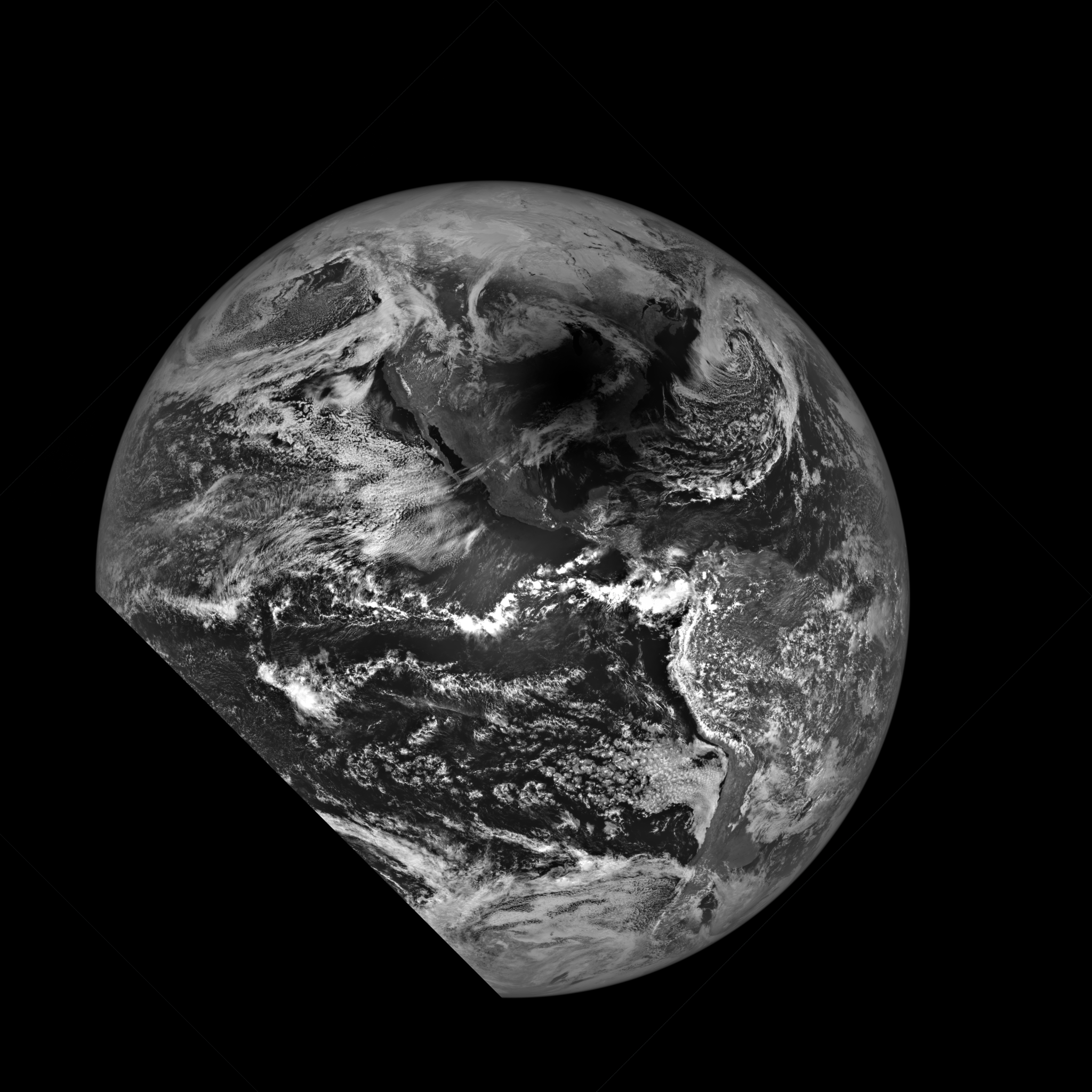
Black and white image of Earth with swirling white clouds and a dark shadow over North America from the Moon eclipsing the Sun.
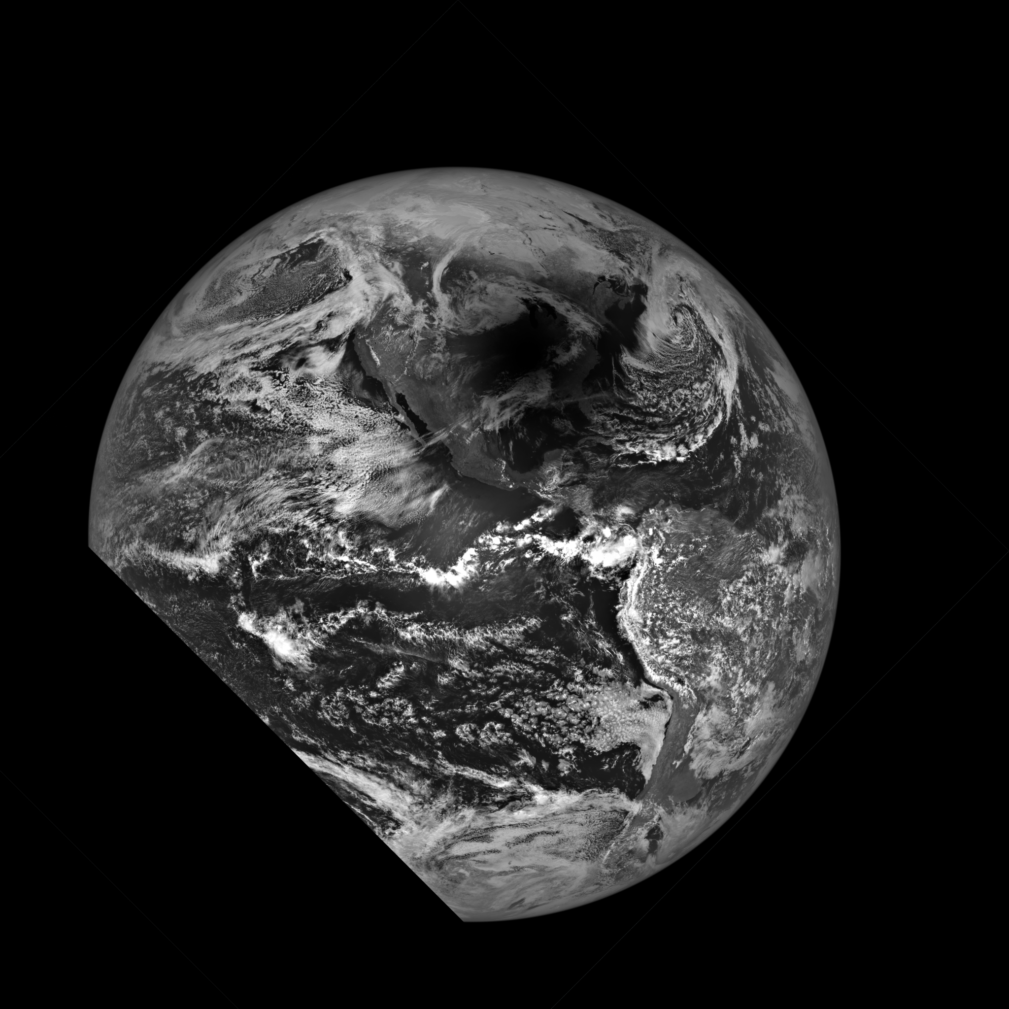
This spectacular image showing the Moon’s shadow on Earth’s surface was acquired during a 20-second period starting at 2:59 p.m. EDT (18:59:19 UTC) on April 8, 2024, by NASA’s Lunar Reconnaissance Orbiter.
NASA/Goddard/Arizona State University

NASA’s Lunar Reconnaissance Orbiter (LRO) captured the April 8, 2024, solar eclipse from hundreds of thousands of miles away. The camera suite aboard the LRO usually retrieves high resolution black and white images of the Moon’s surface; these images provide knowledge of polar illumination conditions, identify potential resources, hazards, and enable safe landing site selection. To take an image of Earth, the LRO has to rapidly rotate to build up the image.

Learn more about the LRO’s cameras and how this image was taken.

Image Credit: NASA/Goddard/Arizona State University

Powered by WPeMatico

Get The Details…
Monika Luabeya

NASA Welcomes Switzerland as Newest Artemis Accords Signatory

NASA Welcomes Switzerland as Newest Artemis Accords Signatory

Swiss Federal Councillor Guy Parmelin, right, shakes hands with NASA Administrator Bill Nelson, left, after signing the Artemis Accords, Monday, April 15, 2024, at the Mary W. Jackson NASA Headquarters building in Washington. Switzerland is the 37th country to sign the Artemis Accords, which establish a practical set of principles to guide space exploration cooperation among nations participating in NASA’s Artemis program.
Credit: NASA/Keegan Bar

Switzerland became the 37th country to sign the Artemis Accords at NASA Headquarters in Washington on Monday, April 15, affirming Switzerland’s commitment to the sustainable and beneficial use of space for all humankind.

“Today, we marked a giant leap forward in the partnership between the United States and Switzerland,” said NASA Administrator Bill Nelson. “As we welcome you into the Artemis Accords family, we expand our commitment to explore the unknown openly and peacefully. Discovery strengthens goodwill on Earth, and we are excited to expand our countries’ shared values and principles to the cosmos.”

At approximately 11:30 a.m., Guy Parmelin, Swiss Federal Councillor and Minister for Economic Affairs, Education & Research, signed the Accords on behalf of Switzerland. Other participants in the ceremony included:

  • Valda Vikmanis-Keller, acting deputy assistant secretary, Department of State
  • Martina Hirayama, state secretary, Head of the State Secretariat for Education, Research, and Innovation
  • Jacques Pitteloud, Swiss Ambassador to the U.S.
  • ESA (European Space Agency) astronaut Marco Sieber, Swiss national
  • Renato Krpoun, Head of Swiss Space Office
  • Professor Peter Wurz, Director Space and Planetary Sciences, University of Bern

“Switzerland has a long-standing partnership with NASA on human space exploration as well as space and Earth sciences,” said Parmelin. “With the signature of the Artemis Accords we renew our commitment to jointly explore the heavens above us.”

The Artemis Accords, established by NASA and the U.S. Department of State in 2020, reinforce the 1968 Treaty on Principles Governing the Activities of States in the Exploration and Use of Outer Space, Including the Moon and Other Celestial Bodies otherwise known as the Outer Space Treaty. They also emphasize a commitment on behalf of the U.S. to the Registration Convention, the Agreement on the Rescue of Astronauts, and other standards that NASA and its partners support.

Many more countries are anticipated to join the Artemis Accords in the months and years to come, as NASA continues to facilitate a safe, peaceful, and prosperous future in space with its international partners.

For more information on the Artemis Accords, visit:

https://www.nasa.gov/artemis-accords

-end-

Lauren Low
Headquarters, Washington
202-358-1600
lauren.e.low@nasa.gov

Powered by WPeMatico

Get The Details…
Lauren E. Low

NASA Sets Path to Return Mars Samples, Seeks Innovative Designs

NASA Sets Path to Return Mars Samples, Seeks Innovative Designs

NASA meatball

NASA Administrator Bill Nelson shared on Monday the agency’s path forward on the Mars Sample Return program, including seeking innovative designs to return valuable samples from Mars to Earth. Such samples will not only help us understand the formation and evolution of our solar system but can be used to prepare for future human explorers and to aid in NASA’s search for signs of ancient life.

Over the last quarter century, NASA has engaged in a systematic effort to determine the early history of Mars and how it can help us understand the formation and evolution of habitable worlds, including Earth. As part of that effort, Mars Sample Return has been a long-term goal of international planetary exploration for the past two decades. NASA’s Perseverance rover has been collecting samples for later collection and return to Earth since it landed on Mars in 2021.

“Mars Sample Return will be one of the most complex missions NASA has ever undertaken. The bottom line is, an $11 billion budget is too expensive, and a 2040 return date is too far away,” said Nelson. “Safely landing and collecting the samples, launching a rocket with the samples off another planet – which has never been done before – and safely transporting the samples more than 33 million miles back to Earth is no small task. We need to look outside the box to find a way ahead that is both affordable and returns samples in a reasonable timeframe.” 

The agency also has released NASA’s response to a Mars Sample Return Independent Review Board report from September 2023. This includes: an updated mission design with reduced complexity; improved resiliency; risk posture; stronger accountability and coordination; and an overall budget likely in the $8 billion to $11 billion range. Given the Fiscal Year 2025 budget and anticipated budget constraints, as well as the need to maintain a balanced science portfolio, the current mission design will return samples in 2040.

To achieve the ambitious goal of returning the key samples to Earth earlier and at a lower cost, the agency is asking the NASA community to work together to develop a revised plan that leverages innovation and proven technology. Additionally, NASA soon will solicit architecture proposals from industry that could return samples in the 2030s, and lowers cost, risk, and mission complexity.

“NASA does visionary science – and returning diverse, scientifically-relevant samples from Mars is a key priority,” said Nicky Fox, associate administrator, Science Mission Directorate, at NASA Headquarters in Washington. “To organize a mission at this level of complexity, we employ decades of lessons on how to run a large mission, including incorporating the input we get from conducting independent reviews. Our next steps will position us to bring this transformational mission forward and deliver revolutionary science from Mars – providing critical new insights into the origins and evolution of Mars, our solar system, and life on Earth.”

For more information about NASA’s research at Mars, visit:

https://www.nasa.gov/mars

-end-

Dewayne Washington / Karen Fox
Headquarters, Washington
202-358-1600
dewayne.a.washington@nasa.gov / karen.fox@nasa.gov

Share

Details

Last Updated

Apr 15, 2024

Powered by WPeMatico

Get The Details…
Abbey A. Donaldson

NASA’s LRO Observes 2024 Solar Eclipse Shadow

NASA’s LRO Observes 2024 Solar Eclipse Shadow

2 min read

Preparations for Next Moonwalk Simulations Underway (and Underwater)

As the Moon blotted out the Sun to viewers across the United States during the April 8 solar eclipse, NASA’s Lunar Reconnaissance Orbiter (LRO) captured an image from some 223,000 miles away of the highly anticipated celestial event.

Black and white image of Earth with swirling white clouds and a dark shadow over the middle portion of the planet from the Moon eclipsing the Sun.
This spectacular image showing the Moon’s shadow on Earth’s surface was acquired during a 20-second period starting at 2:59 p.m. EDT (18:59:19 UTC) on April 8, 2024, by NASA’s Lunar Reconnaissance Orbiter. When LRO acquired this image, the shadow of the Moon was centered near Cape Girardeau, Mo.
NASA/Goddard/Arizona State University

There are three cameras that comprise the LRO camera (LROC) suite: two Narrow Angle Cameras (NAC) and one Wide Angle Camera. The Earth’s image with the shadow in it was acquired by one of the two Narrow Angle Cameras.

The LROC Narrow Angle Cameras are line scanner cameras: they only have one line of pixels, and images are built up line-by-line by the spacecraft’s motion as it orbits the Moon.

Acquiring an image of Earth requires the spacecraft to rapidly rotate to build up the image.

Black and White image with thin wispy clouds focused on Mexico. The land is a dim color due to the shadow of the Moon eclipsing the Sun.
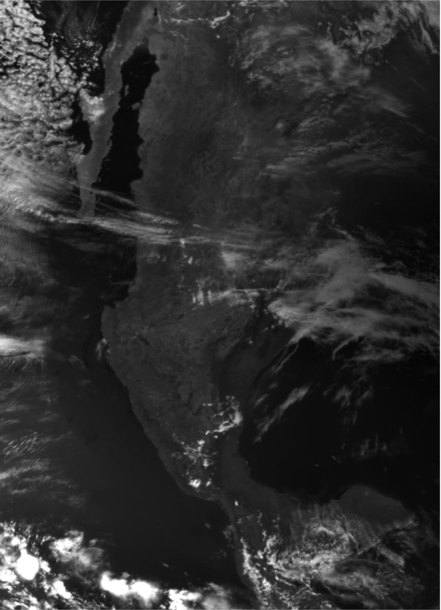
NASA’s Lunar Reconnaissance Orbiter (LRO) image of the eclipse shadow over Mexico and the southern U.S. was captured starting at 2:59 p.m. EDT (18:59:19 UTC) on April 8, 2024.
NASA/Goddard/Arizona State University

LRO is managed by NASA’s Goddard Space Flight Center in Greenbelt, Maryland, for the Science Mission Directorate at NASA Headquarters in Washington. Launched on June 18, 2009, LRO has collected a treasure trove of data with its seven powerful instruments, making an invaluable contribution to our knowledge about the Moon. NASA is returning to the Moon with commercial and international partners to expand human presence in space and bring back new knowledge and opportunities.

By Mark Robinson and edited by Nancy Neal Jones

Media Contacts

Nancy Neal Jones
NASA’s Goddard Space Flight Center, Greenbelt, Md.

Powered by WPeMatico

Get The Details…
Jamie Adkins