NASA Awards Contract for NOAA’s Next-Generation Space Weather Sensors

NASA Awards Contract for NOAA’s Next-Generation Space Weather Sensors

NASA, on behalf of the National Oceanic and Atmospheric Administration (NOAA), has selected Johns Hopkins University’s Applied Physics Laboratory of Laurel, Maryland, to build the Suprathermal Ion Sensors for the Lagrange 1 Series project, part of NOAA’s Space Weather Next Program.

This cost-plus-fixed-fee contract is valued at approximately $20.5 million and includes the development of two Suprathermal Ion Sensor instruments. The anticipated period of performance for this contract will run through Jan. 31, 2034. The work will take place at the awardee’s facility in Maryland, NASA’s Goddard Space Flight Center in Greenbelt, Maryland, and Kennedy Space Center in Florida.

The contract scope includes design, analysis, development, fabrication, integration, test, verification, and evaluation of the Suprathermal Ion Sensor instruments, launch support, supply and maintenance of ground support equipment, and support of post-launch mission operations at the NOAA Satellite Operations Facility.

The Suprathermal Ion Sensors will provide critical data to NOAA’s Space Weather Prediction Center, which issues forecasts, warnings and alerts that help mitigate space weather impacts, including electric power outages and interruption to communications and navigation systems.

The instruments will measure suprathermal ions and electrons across a broad range of energies, and will provide real-time, continuous observations to ensure early warning of various space weather impacts. They also will monitor ions to characterize solar ejections including coronal mass ejections, co-rotating interaction regions, and interplanetary shocks. Analysis of these spectra aids in estimating the arrival time and strength of solar wind shocks.

NASA and NOAA oversee the development, launch, testing, and operation of all the satellites in the L1 Series project. NOAA is the program owner that provides funds and manages the program, operations, and data products and dissemination to users. NASA and commercial partners develop, build, and launch the instruments and spacecraft on behalf of NOAA.

For information about NASA and agency programs, please visit:

https://www.nasa.gov

-end-

Jeremy Eggers
Goddard Space Flight Center, Greenbelt, Md.
757-824-2958
jeremy.l.eggers@nasa.gov

Share

Details

Last Updated

Nov 26, 2024

Editor
Rob Garner
Contact
Jeremy Eggers
Location
Goddard Space Flight Center

Powered by WPeMatico

Get The Details…
Rob Garner
NASA, USAID Invite Media to Launch of New SERVIR Central America Hub

NASA, USAID Invite Media to Launch of New SERVIR Central America Hub

NASA and the U.S. Agency for International Development (USAID) invite media to the official launch celebration of the new SERVIR Central America regional hub, located in Costa Rica, on Tuesday, Dec. 3, at 11 a.m. EST. The event will be hosted by NASA SERVIR Program Manager Daniel Irwin, U.S. Ambassador to El Salvador William H. Duncan, and a representative from El Salvador’s Ministry of Environment and Natural Resources (MARN).

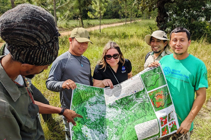
Betzy Hernandez from SERVIR's Science Coordination Office leads a land cover mapping workshop in Belize. NASA and the U.S. Agency for International Development (USAID) are opening a new SERVIR Central America regional hub, located in Costa Rica, on Tuesday, Dec. 3.
Betzy Hernandez from SERVIR’s Science Coordination Office leads a land cover mapping workshop in Belize. NASA and the U.S. Agency for International Development (USAID) are opening a new SERVIR Central America regional hub, located in Costa Rica, on Tuesday, Dec. 3.
NASA

Central America is the latest addition to SERVIR’s global network, a NASA and USAID initiative that has been operating in Asia, Africa, and Latin America since 2005. 

Implemented by the Tropical Agricultural Research and Higher Education Center (CATIE), SERVIR Central America will strengthen climate resilience, sustainable resource management, and biodiversity conservation through satellite data and geospatial technology. The SERVIR Central America hub will support evidence-based decision-making at local, national, and regional levels, strengthening the resilience of more than 40 million people in one of the world’s most climate-vulnerable regions.

The event will be in Spanish with English translation available.

For press access and location details, please RSVP to Belarminda Quijano at belarminda@bqcomunicaciones.com by Monday, Dec. 2. NASA’s media accreditation policy is online. The event will be livestreamed.

For more information on SERVIR, visit:

https://www.nasa.gov/servir

Elizabeth Vlock
Headquarters, Washington
202-358-1600
elizabeth.a.vlock@nasa.gov

Lane Figueroa
Huntsville, Alabama
256-544-0034
lane.e.figueroa@nasa.gov

Powered by WPeMatico

Get The Details…
Lee Mohon

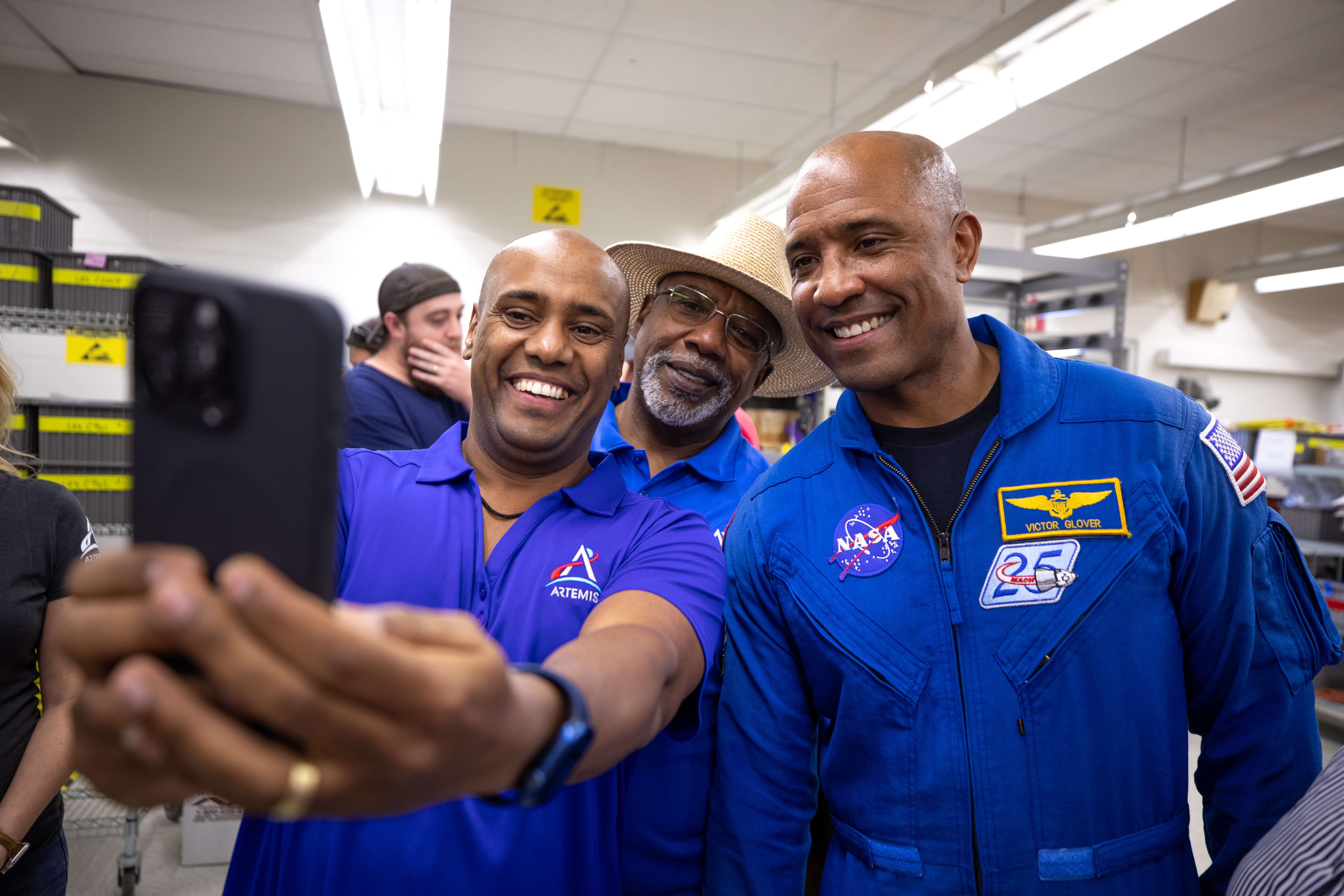
Selfie Time with Astronaut Victor Glover

Selfie Time with Astronaut Victor Glover

Three African American men - two Kennedy Space Center employees wearing blue polo shirts with an Artemis logo (left, middle back) and NASA astronaut Victor Glover (right) - pose for a photo taken with a cell phone.
NASA/Ben Smegelsky

Employees at NASA’s Kennedy Space Center in Florida and NASA astronaut Victor Glover (right) happily snap a photo of themselves during a visit on Nov. 8, 2024. The employees are part of the agency’s Exploration Ground Systems (EGS), which develops and operates the systems and facilities needed to process and launch rockets and spacecraft for NASA’s Artemis missions. EGS plays a primary role in assembly, launch, and recovery of rockets and spacecraft.

Image credit: NASA/Ben Smegelsky

Powered by WPeMatico

Get The Details…
Monika Luabeya

NASA AI, Open Science Advance Disaster Research and Recovery

NASA AI, Open Science Advance Disaster Research and Recovery

4 min read

NASA AI, Open Science Advance Disaster Research and Recovery

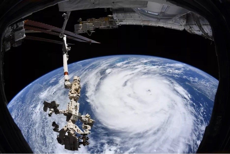
An image of Earth from space showing the swirling clouds of a hurricane forming over the ocean with a robotic arm extending from the International Space Station.
Hurricane Ida is pictured as a category 2 storm from the International Space Station as it orbited 264 miles above the Gulf of Mexico. In the foreground is the Canadarm2 robotic arm with Dextre, the fine-tuned robotic hand, attached.
NASA

By Lauren Perkins

When you think of NASA, disasters such as hurricanes may not be the first thing to come to mind, but several NASA programs are building tools and advancing science to help communities make more informed decisions for disaster planning. 

Empowered by NASA’s commitment to open science, the NASA Disasters Program supports disaster risk reduction, response, and recovery. A core element of the Disasters Program is providing trusted, timely, and actionable data to aid organizations actively responding to disasters.  

Hurricane Ida made landfall in Louisiana Aug. 21, 2021, as a category 4 hurricane, one of the deadliest and most destructive hurricanes in the continental United States on record. The effects of the storm were widespread, causing devastating damage and affecting the lives of millions of people. 

During Hurricane Ida, while first responders and other organizations addressed the storm’s impacts from the ground, the NASA Disasters program was able to provide a multitude of remotely sensed products. Some of the products and models included information on changes in soil moisture, changes in vegetation, precipitation accumulations, flood detection, and nighttime lights to help identify areas of power outages.

Image Before/After

The NASA team shared the data with its partners on the NASA Disasters Mapping Portal and began participating in cross-agency coordination calls to determine how to further aid response efforts. To further connect and collaborate using open science efforts, NASA Disasters overlaid publicly uploaded photos on their Damage Proxy Maps to provide situational awareness of on-the-ground conditions before, during, and after the storm.  

Immediate post-storm response is critical to saving lives; just as making informed, long- term response decisions are critical to providing equitable recovery solutions for all. One example of how this data can be used is blue tarp detection in the aftermath of Hurricane Ida.

Using artificial intelligence (AI) with NASA satellite images, the Interagency Implementation and Advanced Concepts Team (IMPACT), based at NASA’s Marshall Space Flight Center in Huntsville, Alabama, conducted a study to detect the number of blue tarps on rooftops in the aftermath of hurricanes, such as Ida, as a way of characterizing the severity of damage in local communities.

An aerial image that shows homes along a river. Some of the roofs appear blue where the blue tarps are covering damage.
An aerial photograph shows damaged roofs from Hurricane Maria in 2017 in Barrio Obrero, Puerto Rico. In the wake of the hurricane, the Federal Emergency Management Agency (FEMA) and United States Army Corps of Engineers distributed 126,000 blue tarps and nearly 60,000 temporary blue roofs to people awaiting repairs on damaged homes.
NASA

While disasters cannot be avoided altogether, timely and accessible information helps communities worldwide reduce risk, improve response, hasten recovery, and build disaster resilience.  

Through an initiative led by NASA’s Office of the Chief Science Data Officer, NASA and IBM are developing five open-source artificial intelligence foundation models trained on NASA’s expansive satellite repositories. This effort will help make NASA’s vast, ever-growing amounts of data more accessible and usable. Leveraging NASA’s AI expertise allows users to make faster, more informed decisions. User applications of the Prithvi Earth Foundation Models could range from identifying flood risks and predicting crop yields to forecasting long range atmospheric weather patterns.

“NASA is dedicated to ensuring that our scientific data are accessible and beneficial to all. Our AI foundation models are scientifically validated and adaptable to new data, designed to maximize efficiency and lower technical barriers. This ensures that even in the face of challenging disasters, response teams can be swift and effective,” said Kevin Murphy, NASA’s chief science data officer. “Through these efforts, we’re not only advancing scientific frontiers, but also delivering tangible societal benefits, providing data that can safeguard lives and improve resilience against future threats.” 

Hear directly from some of the data scientists building these AI models, the NASA disaster response team, as well as hurricane hunters that fly directly into these devastating storms on NASA’s Curious Universe podcast. 

Learn more about NASA’s AI for Science models at https://science.nasa.gov/artificial-intelligence-science/.

Share

Details

Last Updated
Nov 26, 2024
Keep Exploring

Discover More Topics From NASA

Powered by WPeMatico

Get The Details…

Discovery Alert: a ‘Hot Neptune’ in a Tight Orbit

Discovery Alert: a ‘Hot Neptune’ in a Tight Orbit

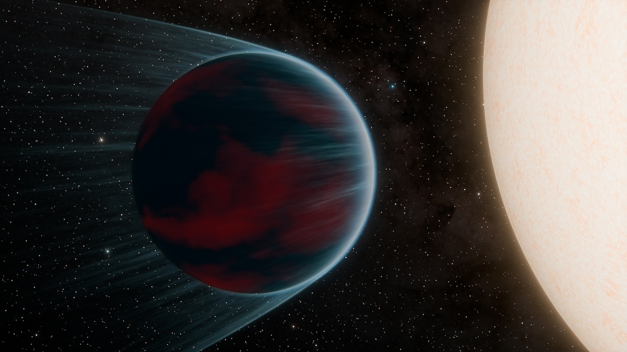
A dark planet, left, is shown in close orbit around its star, right; some of the planet's atmosphere is being blown outward by the star.
Artist’s concept of “hot Neptune” TOI-3261 b.
NASA/JPL-Caltech/K. Miller (Caltech/IPAC)

By Grace Jacobs Corban

The Discovery

A Neptune-sized planet, TOI-3261 b, makes a scorchingly close orbit around its host star. Only the fourth object of its kind ever found, the planet could reveal clues as to how planets such as these form.

Key Facts

An international team of scientists used the NASA space telescope, TESS (the Transiting Exoplanet Survey Satellite), to discover the exoplanet (a planet outside our solar system), then made further observations with ground-based telescopes in Australia, Chile, and South Africa. The measurements placed the new planet squarely in the “hot Neptune desert” – a category of planets with so few members that their scarcity evokes a deserted landscape. This variety of exoplanet is similar to our own Neptune in size and composition, but orbits extremely closely to its star. In this case, a “year” on TOI-3261 b is only 21 hours long. Such a tight orbit earns this planet its place in an exclusive group with, so far, only three other members: ultra-short-period hot Neptunes whose masses have been precisely measured.

Details

Planet TOI-3261 b proves to be an ideal candidate to test new computer models of planet formation. Part of the reason hot Neptunes are so rare is that it is difficult to retain a thick gaseous atmosphere so close to a star. Stars are massive, and so exert a large gravitational force on the things around them, which can strip the layers of gas surrounding a nearby planet. They also emit huge amounts of energy, which blow the gas layers away. Both of these factors mean that hot Neptunes such as TOI-3261 b might have started out as much larger, Jupiter-sized planets, and have since lost a large portion of their mass.

By modeling different starting points and development scenarios, the science team determined that the star and planet system is about 6.5 billion years old, and that the planet started out as a much larger gas giant. It likely lost mass, however, in two ways: photoevaporation, when energy from the star causes gas particles to dissipate, and tidal stripping, when the gravitational force from the star strips layers of gas from the planet. The planet also might have formed farther away from its star, where both of these effects would be less intense, allowing it to retain its atmosphere.

The remaining atmosphere of the planet, one of its most interesting features, will likely invite further atmospheric analysis, perhaps helping to unravel the formation history of this denizen of the “hot Neptune desert.” Planet TOI-3261 b is about twice as dense as Neptune, indicating that the lighter parts of its atmosphere have been stripped away over time, leaving only the heavier components. This shows that the planet must have started out with a variety of different elements in its atmosphere, but at this stage, it is hard to tell exactly what. This mystery could be solved by observing the planet in infrared light, perhaps using NASA’s James Webb Space Telescope – an ideal way to see the identifying fingerprints of the different molecules in the planet’s atmosphere. This will not just help astronomers understand the past of TOI-3261 b, but also begin to uncover the physical processes behind all hot, giant planets.

Fun Facts

The first-ever discovery of an ultra-short-period hot Neptune, LTT-9779 b, came in 2020. Since then, TESS discoveries TOI-849 b and TOI-332 b have also joined the elite ultra-short-period hot-Neptune club (with masses that have been precisely measured). Both LTT-9779 b and TOI-849 b are in the queue for infrared observations with the James Webb Space Telescope, potentially broadening our understanding of these planets’ atmospheres in the coming years.

The Discoverers

An international science team led by astronomer Emma Nabbie of the University of Southern Queensland published their paper on the discovery, “Surviving in the Hot Neptune Desert: The Discovery of the Ultrahot Neptune TOI-3261 b,” in The Astronomical Journal in August 2024.

Powered by WPeMatico

Get The Details…