They Grow So Fast: Moon Tree Progress Since NASA’s Artemis I Mission

They Grow So Fast: Moon Tree Progress Since NASA’s Artemis I Mission
3 Min Read

They Grow So Fast: Moon Tree Progress Since NASA’s Artemis I Mission

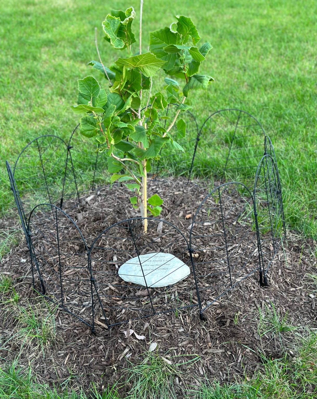
A small Artemis Moon Tree planted in the ground with a circular marker and bordered by a fence

In the two years since NASA’s Orion spacecraft returned to Earth with more than 2,000 tree seedlings sourced in a partnership with USDA Forest Service, Artemis I Moon trees have taken root at 236 locations across the contiguous United States. Organizations are cultivating more than just trees, as they nurture community connections, spark curiosity about space, and foster a deeper understanding of NASA’s missions.

Universities, federal agencies, museums, and other organizations who were selected to be Moon tree recipients have branched out to provide their community unique engagements with their seedling.

Children sitting in a circle around a newly planted Moon tree and learning about NASA's Artemis I mission.
Children sitting in a circle around a newly planted Moon tree and learning about NASA’s Artemis I mission.
Adria Gillespie

“Through class visits to the tree, students have gained a lot of interest in caring for the tree, and their curiosity for the unknown in outer space sparked them to do research of their own to get answers to their inquiries,” said Adria Gillespie, the district science coach at Greenfield Union School District in Greenfield, California.

The presence of a Moon tree at schools has blossomed into more student engagements surrounding NASA’s missions. Along with planting their American Sycamore, students from Eagle Pointe Elementary in Plainfield, Illinois, are participating in a Lunar Quest club to learn about NASA and engage in a simulated field trip to the Moon.

Eagle Pointe Elementary students also took part in a planting ceremony for their seedling, where they buried a time capsule with the seed, and established a student committee responsible for caring for their Moon tree.

At Marshall STEMM Academy in Toledo, Ohio, second grade students were assigned reading activities associated with their Moon tree, fourth graders created Moon tree presentations to show the school, and students engaged with city leaders and school board members to provide a Moon tree dedication.

Two individuals planting a Moon tree.
Brandon Dillman

A seedling sent to The Gathering Garden in Mount Gilead, North Carolina, is cared for by community volunteers. Lessons with local schools and 4-H clubs, as well as the establishment of newsletters and social media to maintain updates, have sprouted from The Gathering Garden’s Loblolly Pine.

Sprucing Up the Moon Trees’ Environment

In addition to nurturing their Moon tree, many communities have planted other trees alongside their seedling to foster a healthier environment. In Castro Valley, California, a non-profit called ForestR planted oak, fir, and sequoia trees to nestle their seedling among a tree “family.”

New homes for additional Moon tree seedlings are being identified each season through Fall 2025. Communities continue to track how the impact of NASA’s science and innovation grows alongside their Moon trees.

NASA’s “new generation” Moon trees originally blossomed from NASA’s Apollo 14 mission, where NASA astronaut Stuart Roosa carried tree seeds into lunar orbit. NASA’s Next Generation STEM project partnered with USDA Forest Service to bring Moon trees to selected organizations. As NASA continues to work for the benefit of all, its Moon trees have demonstrated how one tiny seed can sprout positive change for communities, the environment, and education.

Learn more about NASA’s STEM engagements: https://stem.nasa.gov
Powered by WPeMatico

Get The Details…
Sandra May

GSFC Data Science Group Releases Innovative Foundation Model: SatVision Top-Of-Atmosphere (TOA)

GSFC Data Science Group Releases Innovative Foundation Model: SatVision Top-Of-Atmosphere (TOA)

At Goddard Space Flight Center, the GSFC Data Science Group has completed the testing for their SatVision Top-of-Atmosphere (TOA) Foundation Model, a geospatial foundation model for coarse-resolution all-sky remote sensing imagery. The team, comprised of Mark Carroll, Caleb Spradlin, Jordan Caraballo-Vega, Jian Li, Jie Gong, and Paul Montesano, has now released their model for wide application in science investigations.

Foundation models can transform the landscape of remote sensing (RS) data analysis by enabling the pre-training of large computer-vision models on vast amounts of remote sensing data. These models can be fine-tuned with small amounts of labeled training and applied to various mapping and monitoring applications. Because most existing foundation models are trained solely on cloud-free satellite imagery, they are limited to applications of land surface or require atmospheric corrections. SatVision-TOA is trained on all-sky conditions which enables applications involving atmospheric variables (e.g., cloud or aerosol).

SatVision TOA is a 3 billion parameter model trained on 100 million images from Moderate Resolution Imaging Spectroradiometer (MODIS). This is, to our knowledge, the largest foundation model trained solely on satellite remote sensing imagery. By including “all-sky” conditions during pre-training, the team incorporated a range of cloud conditions often excluded in traditional modeling. This enables 3D cloud reconstruction and cloud modeling in support of Earth and climate science, offering significant enhancement for large-scale earth observation workflows.

With an adaptable and scalable model design, SatVision-TOA can unify diverse Earth observation datasets and reduce dependency on task-specific models. SatVision-TOA leverages one of the largest public datasets to capture global contexts and robust features. The model could have broad applications for investigating spectrometer data, including MODIS, VIIRS, and GOES-ABI. The team believes this will enable transformative advancements in atmospheric science, cloud structure analysis, and Earth system modeling.

The model architecture and model weights are available on GitHub and Hugging Face, respectively. For more information, including a detailed user guide, see the associated white paper: SatVision-TOA: A Geospatial Foundation Model for Coarse-Resolution All-Sky Remote Sensing Imagery

Examples of image reconstruction by SatVision-TOA. Left: MOD021KM v6.1 cropped image chip using MODIS bands [1, 3, 2]. Middle: The same images with randomly applied 8 × 8 mask patches, masking 60% of the original image. Right: The reconstructed images produced by the model, along with their respective Structural Similarity Index Measure (SSIM) scores. These examples illustrate the model’s ability to preserve structural detail and reconstruct heterogeneous features, such as cloud textures and land-cover transitions, with high fidelity.
Examples of image reconstruction by SatVision-TOA. Left: MOD021KM v6.1 cropped image chip using MODIS bands [1, 3, 2]. Middle: The same images with randomly applied 8×8 mask patches, masking 60% of the original image. Right: The reconstructed images produced by the model, along with their respective Structural Similarity Index Measure (SSIM) scores. These examples illustrate the model’s ability to preserve structural detail and reconstruct heterogeneous features, such as cloud textures and land-cover transitions, with high fidelity.
NASA

Powered by WPeMatico

Get The Details…
Maya L. Kikuchi

NASA Performs First Aircraft Accident Investigation on Another World

NASA Performs First Aircraft Accident Investigation on Another World

5 min read

Preparations for Next Moonwalk Simulations Underway (and Underwater)

NASA’s Ingenuity Mars Helicopter
NASA’s Ingenuity Mars Helicopter, right, stands near the apex of a sand ripple in an image taken by Perseverance on Feb. 24, 2024, about five weeks after the rotorcraft’s final flight. Part of one of Ingenuity’s rotor blades lies on the surface about 49 feet (15 meters) west of helicopter (at left in image).
NASA/JPL-Caltech/LANL/CNES/CNRS

The review takes a close look the final flight of the agency’s Ingenuity Mars Helicopter, which was the first aircraft to fly on another world.

Engineers from NASA’s Jet Propulsion Laboratory in Southern California and AeroVironment are completing a detailed assessment of the Ingenuity Mars Helicopter’s final flight on Jan. 18, 2024, which will be published in the next few weeks as a NASA technical report. Designed as a technology demonstration to perform up to five experimental test flights over 30 days, Ingenuity was the first aircraft on another world. It operated for almost three years, performed 72 flights, and flew more than 30 times farther than planned while accumulating over two hours of flight time.

The investigation concludes that the inability of Ingenuity’s navigation system to provide accurate data during the flight likely caused a chain of events that ended the mission. The report’s findings are expected to benefit future Mars helicopters, as well as other aircraft destined to operate on other worlds.

NASA’s Ingenuity Mars Helicopter used its black-and-white navigation camera to capture this video on Feb. 11, 2024, showing the shadow of its rotor blades. The imagery confirmed damage had occurred during Flight 72.
NASA/JPL-Caltech

Final Ascent

Flight 72 was planned as a brief vertical hop to assess Ingenuity’s flight systems and photograph the area. Data from the flight shows Ingenuity climbing to 40 feet (12 meters), hovering, and capturing images. It initiated its descent at 19 seconds, and by 32 seconds the helicopter was back on the surface and had halted communications. The following day, the mission reestablished communications, and images that came down six days after the flight revealed Ingenuity had sustained severe damage to its rotor blades.

What Happened

“When running an accident investigation from 100 million miles away, you don’t have any black boxes or eyewitnesses,” said Ingenuity’s first pilot, Håvard Grip of JPL. “While multiple scenarios are viable with the available data, we have one we believe is most likely: Lack of surface texture gave the navigation system too little information to work with.”

The helicopter’s vision navigation system was designed to track visual features on the surface using a downward-looking camera over well-textured (pebbly) but flat terrain. This limited tracking capability was more than sufficient for carrying out Ingenuity’s first five flights, but by Flight 72 the helicopter was in a region of Jezero Crater filled with steep, relatively featureless sand ripples.

This short animation depicts a NASA concept for a proposed follow-on to the agency’s Ingenuity Mars Helicopter called Mars Chopper, which remains in early conceptual and design stages. In addition to scouting, such a helicopter could carry science instruments to study terrain rovers can’t reach.

One of the navigation system’s main requirements was to provide velocity estimates that would enable the helicopter to land within a small envelope of vertical and horizontal velocities. Data sent down during Flight 72 shows that, around 20 seconds after takeoff, the navigation system couldn’t find enough surface features to track.

Photographs taken after the flight indicate the navigation errors created high horizontal velocities at touchdown. In the most likely scenario, the hard impact on the sand ripple’s slope caused Ingenuity to pitch and roll. The rapid attitude change resulted in loads on the fast-rotating rotor blades beyond their design limits, snapping all four of them off at their weakest point — about a third of the way from the tip. The damaged blades caused excessive vibration in the rotor system, ripping the remainder of one blade from its root and generating an excessive power demand that resulted in loss of communications.

This graphic depicts the most likely scenario for the hard landing of NASA’s Ingenuity Mars Helicopter
This graphic depicts the most likely scenario for the hard landing of NASA’s Ingenuity Mars Helicopter during its 72nd and final flight on Jan. 18, 2024. High horizontal velocities at touchdown resulted in a hard impact on a sand ripple, which caused Ingenuity to pitch and roll, damaging its rotor blades.
NASA/JPL-Caltech

Down but Not Out

Although Flight 72 permanently grounded Ingenuity, the helicopter still beams weather and avionics test data to the Perseverance rover about once a week. The weather information could benefit future explorers of the Red Planet. The avionics data is already proving useful to engineers working on future designs of aircraft and other vehicles for the Red Planet.

“Because Ingenuity was designed to be affordable while demanding huge amounts of computer power, we became the first mission to fly commercial off-the-shelf cellphone processors in deep space,” said Teddy Tzanetos, Ingenuity’s project manager. “We’re now approaching four years of continuous operations, suggesting that not everything needs to be bigger, heavier, and radiation-hardened to work in the harsh Martian environment.”

Inspired by Ingenuity’s longevity, NASA engineers have been testing smaller, lighter avionics that could be used in vehicle designs for the Mars Sample Return campaign. The data is also helping engineers as they research what a future Mars helicopter could look like — and do.

During a Wednesday, Dec. 11, briefing at the American Geophysical Union’s annual meeting in Washington, Tzanetos shared details on the Mars Chopper rotorcraft, a concept that he and other Ingenuity alumni are researching. As designed, Chopper is approximately 20 times heavier than Ingenuity, could fly several pounds of science equipment, and autonomously explore remote Martian locations while traveling up to 2 miles (3 kilometers) in a day. (Ingenuity’s longest flight was 2,310 feet, or 704 meters.)

“Ingenuity has given us the confidence and data to envision the future of flight at Mars,” said Tzanetos.

More About Ingenuity

The Ingenuity Mars Helicopter was built by JPL, which also manages the project for NASA Headquarters. It is supported by NASA’s Science Mission Directorate. NASA’s Ames Research Center in California’s Silicon Valley and NASA’s Langley Research Center in Hampton, Virginia, provided significant flight performance analysis and technical assistance during Ingenuity’s development. AeroVironment, Qualcomm, and SolAero also provided design assistance and major vehicle components. Lockheed Space designed and manufactured the Mars Helicopter Delivery System. At NASA Headquarters, Dave Lavery is the program executive for the Ingenuity Mars helicopter.

For more information about Ingenuity:

https://mars.nasa.gov/technology/helicopter

News Media Contacts

DC Agle
Jet Propulsion Laboratory, Pasadena, Calif.
818-393-9011
agle@jpl.nasa.gov

Karen Fox / Molly Wasser
NASA Headquarters, Washington
202-358-1600
karen.c.fox@nasa.gov / molly.l.wasser@nasa.gov

2024-171

Powered by WPeMatico

Get The Details…
Anthony Greicius

Space Meets Sound: NASA Lands in 2024 Spotify Wrapped

Space Meets Sound: NASA Lands in 2024 Spotify Wrapped

NASA’s podcasts let you experience the thrill of space exploration without ever leaving Earth.
Credit: NASA

NASA’s audio storytelling reached new frontiers in 2024, with Spotify Wrapped revealing the agency’s podcasts as a favorite among listeners worldwide. In celebration of the milestone, NASA astronaut Nick Hague spoke with Spotify about what space sounded like this year.

“Music is one of those things that connects us to the planet,” said Hague, in the video released on Spotify and NASA social accounts. “Music is a vital part of life up here. The soundtrack up here, it’s just going all the time. Everybody’s got their own flavor of music. Every Friday night the crew gets together, we turn on music and we stream things that we like. Whether they’re into pop or hard rock, it’s an international mix. When I think of space walks, I think of classical music, slow, methodical tunes, because that is the way that we conduct spacewalks. Slowly and methodically. Classical music captures the essence of, just floating in space.”

With listeners in more than 100 countries, NASA podcasts reached new audiences and inspired people around the world on Spotify this year. Other 2024 highlights included:

  • Ranked as a top choice for thousands of listeners seeking to learn about science and space.
  • Spent a combined 37 weeks in Spotify’s top charts for science podcasts.
  • The top streamed podcast was “NASA’s Curious Universe”, and the top streamed episode was “A Year in Mars Dune Alpha.”

“We’re thrilled to have our space-centric content featured in Spotify Wrapped 2024,” said Brittany Brown, director of digital communications, NASA Headquarters in Washington. “Our collaboration with Spotify is a testament to NASA’s commitment to producing innovative and engaging content. We’re excited to see how audiences continue to respond to this unique listening experience only NASA can provide.”

The agency’s podcasts cover a wide range of topics, including in-depth conversations with NASA astronauts, stories that take audiences on a tour of the galaxy, and Spanish-language content.

“Music, just like space, connects us all,” said Katie Konans, audio program lead, eMITS contract with NASA. “Our partnership with Spotify has allowed NASA to share the wonder and excitement of space with music and podcast lovers globally. This year, we’re thrilled to take this connection to new heights by bringing the Spotify Wrapped 2024 conversation beyond planet Earth.”

NASA released its collection of original podcasts on Spotify in 2023, furthering the agency’s mission to engage the Artemis Generation in the science, space exploration, and discovery.

In addition to Spotify, users may find NASA podcasts on Apple Podcasts, Google Podcasts, and Soundcloud.

Discover all of NASA’s podcasts at:

https://www.nasa.gov/podcasts

-end-

Abbey Donaldson
Headquarters, Washington
202-358-1600
abbey.a.donaldson@nasa.gov

Powered by WPeMatico

Get The Details…
Tiernan P. Doyle

NASA Astronauts O’Hara and Moghbeli Explore Earth Data

NASA Astronauts O’Hara and Moghbeli Explore Earth Data

Two women in blue jumpsuits stand in a room with black walls and a black floor. The walls and floor have infographics, and data points on them related to Earth. The woman at left, NASA astronaut Loral O'Hara, looks up and to the side. The other woman, NASA astronaut Jasmin Moghbeli, faces the other way.
NASA/Joel Kowsky

On Dec. 4, 2024, NASA astronauts Loral O’Hara, left, and Jasmin Moghbeli spent a moment in part of the Earth Information Center, an immersive experience combining live NASA data sets with innovative data visualization and storytelling at NASA Headquarters in Washington.

O’Hara and Moghbeli spent six months in space as part of Expedition 70 aboard the International Space Station. On Nov. 1, 2023, they performed a spacewalk together that lasted 6 hours and 42 minutes.

Image credit: NASA/Joel Kowsky

Powered by WPeMatico

Get The Details…
Monika Luabeya