NASA’s SPHEREx Team To Ring New York Stock Exchange Bell

NASA’s SPHEREx Team To Ring New York Stock Exchange Bell

NASA’s SPHEREx (Spectro-Photometer for the History of the Universe, Epoch of Reionization and Ices Explorer), a space telescope, is situated on a work stand ahead of prelaunch operations at the Astrotech Processing Facility at Vandenberg Space Force Base in California on Jan. 16, 2025.
Credit: BAE Systems/Benjamin Fry

Members of the team behind NASA’s newest space telescope will ring the New York Stock Exchange closing bell in New York City at 4 p.m. EDT on Tuesday, April 22. The team helped build, launch, and operates NASA’s SPHEREx (Spectro-Photometer for the History of the Universe, Epoch of Reionization and Ices Explorer) mission to explore the origins of the universe. The New York Stock Exchange will share a recording of the closing bell ceremony on YouTube after the event.

After launching March 11 from Vandenberg Space Force Base in California on a SpaceX Falcon 9 rocket, SPHEREx will soon begin collecting data on more than 450 million galaxies and 100 million stars in the Milky Way, to improve our understanding of how the universe evolved and search for key ingredients for life in our galaxy. The observatory’s first images confirmed all of the telescope’s systems are working as expected, as the team prepares SPHEREx to begin mapping the entire sky.

Bell ringers from NASA’s Jet Propulsion Laboratory, which manages the mission, will be joined by team members from BAE Systems Inc., Space & Mission Systems, which built the telescope and spacecraft’s main structure, known as a bus, for NASA.

For more information on SPHEREx, visit:

https://www.nasa.gov/spherex

-end-

Alise Fisher
Headquarters, Washington
202-358-1100
alise.m.fisher@nasa.gov

Calla Cofield
Jet Propulsion Laboratory, Pasadena, Calif.
626-808-2469
calla.e.cofield@jpl.nasa.gov

Powered by WPeMatico

Get The Details…
Jessica Taveau

NASA’s Lucy Spacecraft Images Asteroid Donaldjohanson

NASA’s Lucy Spacecraft Images Asteroid Donaldjohanson

4 min read

NASA’s Lucy Spacecraft Images Asteroid Donaldjohanson

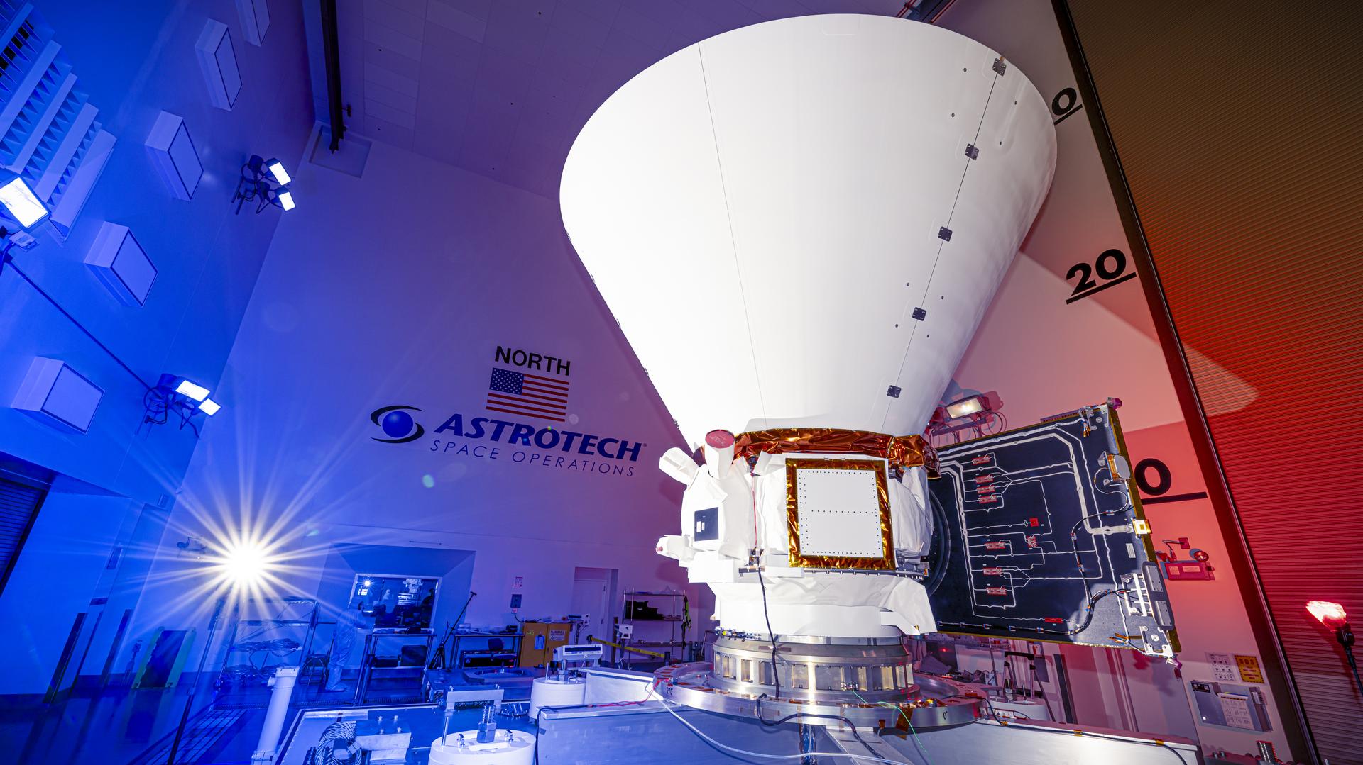
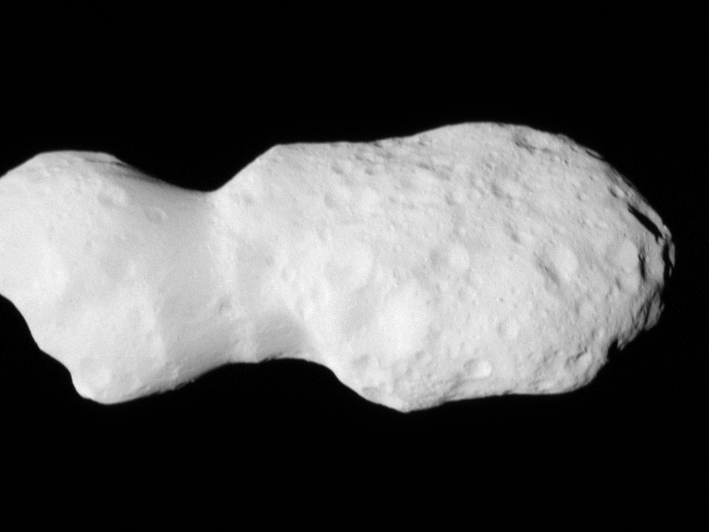
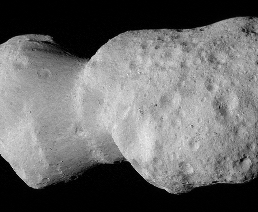
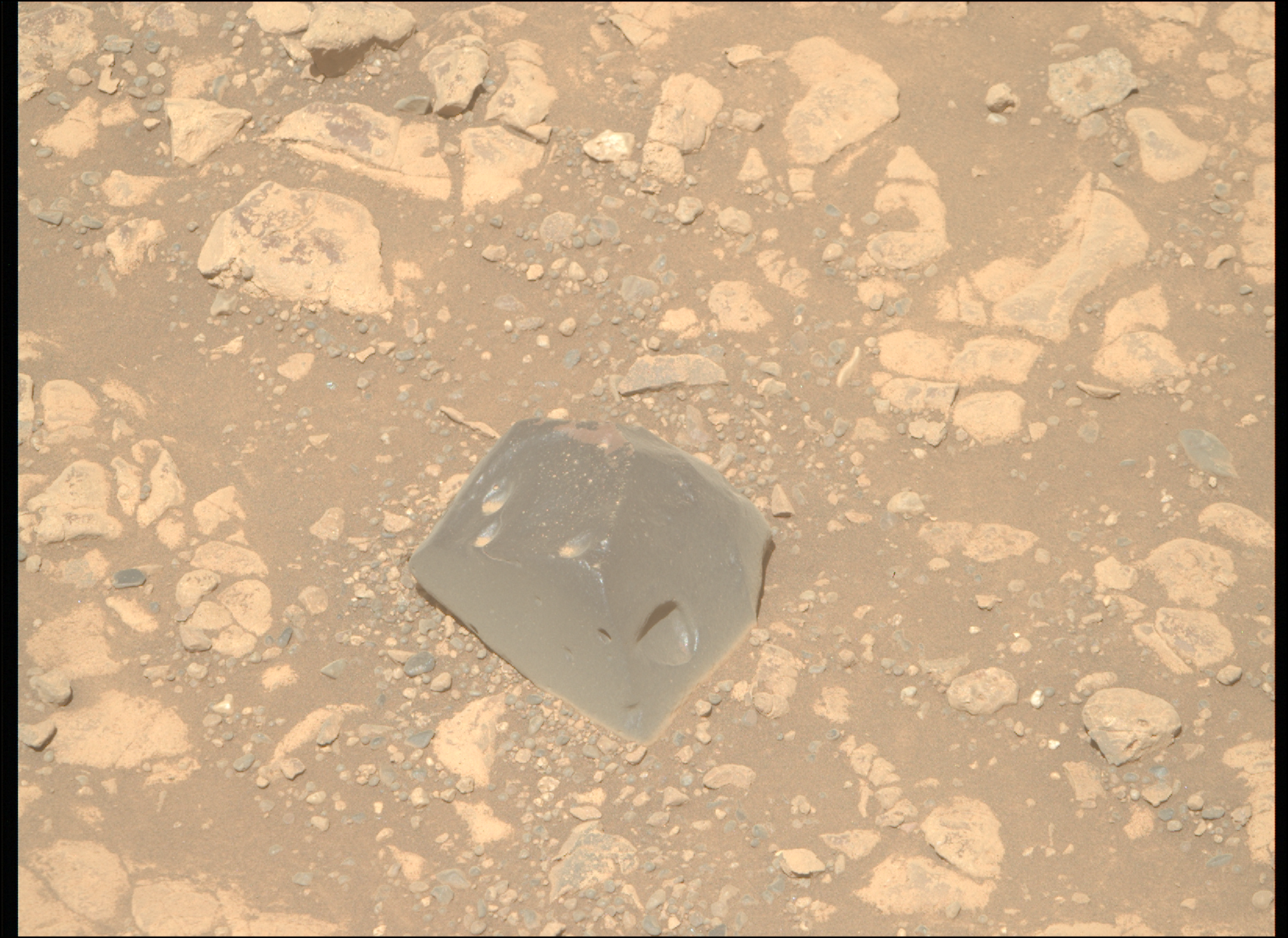
In its second asteroid encounter, NASA’s Lucy spacecraft obtained a close look at a uniquely shaped fragment of an asteroid that formed about 150 million years ago. The spacecraft has begun returning images that were collected as it flew approximately 600 miles (960 km) from the asteroid Donaldjohanson on April 20, 2025.

Gif of Asteroid Donaldjohanson, as seen by the Lucy spacecraft during its close flyby. The asteroid looks like two lobes, attached by a thinner cylinder, like a barbell with very large weights. One lobe is smaller than the other. Although they are both about the same circumference, the smaller lobe is less wide than the other. The asteroid is a smooth, light gray surface, with smooth-edged craters dimpling its surface. The larger lobe has many more craters. The asteroid moves closer to the camera, pushing in on the larger lobe. Then it rotates slightly to look along the asteroid long-ways.
The asteroid Donaldjohanson as seen by the Lucy Long-Range Reconnaissance Imager (L’LORRI) on NASA’s Lucy spacecraft during its flyby. This timelapse shows images captured approximately every 2 seconds beginning at 1:50 p.m. EDT (17:50 UTC), April 20, 2025. The asteroid rotates very slowly; its apparent rotation here is due to the spacecraft’s motion as it flies by Donaldjohanson at a distance of 1,000 to 660 miles (1,600 to 1,100 km). The spacecraft’s closest approach distance was 600 miles (960 km), but the images shown were taken approximately 40 seconds beforehand, the nearest ones at a distance of 660 miles (1100 km).
NASA/Goddard/SwRI/Johns Hopkins APL

The asteroid was previously observed to have large brightness variations over a 10-day period, so some of Lucy team members’ expectations were confirmed when the first images showed what appeared to be an elongated contact binary (an object formed when two smaller bodies collide). However, the team was surprised by the odd shape of the narrow neck connecting the two lobes, which looks like two nested ice cream cones.

“Asteroid Donaldjohanson has strikingly complicated geology,” says Hal Levison, principal investigator for Lucy at Southwest Research Institute, Boulder, Colorado. “As we study the complex structures in detail, they will reveal important information about the building blocks and collisional processes that formed the planets in our Solar System.”

From a preliminary analysis of the first available images collected by the spacecraft’s L’LORRI imager, the asteroid appears to be larger than originally estimated, about 5 miles (8 km) long and 2 miles (3.5 km) wide at the widest point. In this first set of high-resolution images returned from the spacecraft, the full asteroid is not visible as the asteroid is larger than the imager’s field of view. It will take up to a week for the team to downlink the remainder of the encounter data from the spacecraft; this dataset will give a more complete picture of the asteroid’s overall shape.

Like Lucy’s first asteroid flyby target, Dinkinesh, Donaldjohanson is not a primary science target of the Lucy mission. As planned, the Dinkinesh flyby was a system’s test for the mission, while this encounter was a full dress rehearsal, in which the team conducted a series of dense observations to maximize data collection. Data collected by Lucy’s other scientific instruments, the L’Ralph color imager and infrared spectrometer and the L’TES thermal infrared spectrometer, will be retrieved and analyzed over the next few weeks.

The Lucy spacecraft will spend most of the remainder of 2025 travelling through the main asteroid belt. Lucy will encounter the mission’s first main target, the Jupiter Trojan asteroid Eurybates, in August 2027.

“These early images of Donaldjohanson are again showing the tremendous capabilities of the Lucy spacecraft as an engine of discovery,” said Tom Statler, program scientist for the Lucy mission at NASA Headquarters in Washington. “The potential to really open a new window into the history of our solar system when Lucy gets to the Trojan asteroids is immense.”

Asteroid Donaldjohanson, as seen by the Lucy spacecraft during its close flyby. The asteroid looks like two lobes, attached by a thinner cylinder, like a barbell with very large weights. One lobe is smaller than the other. Although they are both about the same circumference, the smaller lobe is less wide than the other. The asteroid is a smooth, light gray surface, with smooth-edged craters dimpling its surface. The larger lobe has many more craters.
The asteroid Donaldjohanson as seen by the Lucy Long-Range Reconnaissance Imager (L’LORRI). This is one of the most detailed images returned by NASA’s Lucy spacecraft during its flyby. This image was taken at 1:51 p.m. EDT (17:51 UTC), April 20, 2025, near closest approach, from a range of approximately 660 miles (1,100 km). The spacecraft’s closest approach distance was 600 miles (960 km), but the image shown was taken approximately 40 seconds beforehand. The image has been sharpened and processed to enhance contrast.
NASA/Goddard/SwRI/Johns Hopkins APL/NOIRLab

NASA’s Goddard Space Flight Center in Greenbelt, Maryland, provides overall mission management, systems engineering and the safety and mission assurance for Lucy, as well as the designing and building the L’Ralph instrument. Hal Levison of the Boulder, Colorado, office of SwRI is the principal investigator. SwRI is headquartered in San Antonio and also leads the mission’s science team, science observation planning, and data processing. NASA’s Goddard Space Flight Center in Greenbelt, Maryland, provides overall mission management, systems engineering, and the safety and mission assurance for Lucy, as well as the L’Ralph instrument. Lockheed Martin Space in Littleton, Colorado, built the spacecraft, designed the orbital trajectory, and provides flight operations. Goddard and KinetX Aerospace are responsible for navigating the Lucy spacecraft. The Johns Hopkins Applied Physics Laboratory in Laurel, Maryland, designed and built the L’LORRI (Lucy Long Range Reconnaissance Imager) instrument. Arizona State University designed and built the L’TES (Lucy Thermal Emission Spectrometer). Lucy is the thirteenth mission in NASA’s Discovery Program, which is managed by NASA’s Marshall Space Flight Center in Huntsville, Alabama.

By Katherine Kretke
Southwest Research Institute

Media Contact:
Karen Fox / Molly Wasser
Headquarters, Washington
202-358-1600
karen.c.fox@nasa.gov / molly.l.wasser@nasa.gov

Nancy N. Jones
NASA’s Goddard Space Flight Center, Greenbelt, Md.

Share

Details

Last Updated
Apr 21, 2025
Editor
Jamie Adkins
Contact

Powered by WPeMatico

Get The Details…

Fuzzy Rings of a Dying Star

Fuzzy Rings of a Dying Star

What looks like a single large, bright star (but is two) shines with bright purple diffraction spikes at the center of a large, diffuse cylinder of gas and dust that is tipped to the right. At the center is a bright pink clumpy cloud that takes up about 25% of the view. The pink region has some holes and diffuse areas. Beyond that are two large rings seen at a roughly 60-degree angle that appear joined at top left and bottom right. The edges are denser, and form shallow V-shapes that go inward. The rings appear orange at top left and bottom right, and are blue at bottom and center right. There is diffuse orange material around the body. The black background of space is speckled with tiny stars and galaxies mostly in blues and yellows. A bigger blue star with spikes is just below and to the left of the central stars, but it is slightly smaller. Areas Webb did not observe are along the top edges, a thin vertical near the nebula at top left, and at the bottom left and right corners.
NASA’s James Webb Space Telescope has taken the most detailed image of planetary nebula NGC 1514 to date thanks to its unique mid-infrared observations. Webb shows its rings as intricate clumps of dust. It’s also easier to see holes punched through the bright pink central region.
NASA, ESA, CSA, STScI, Michael Ressler (NASA-JPL), Dave Jones (IAC)

In this photo released on April 14, 2025, NASA’s James Webb Space Telescope revealed the gas and dust ejected by a dying star at the heart of NGC 1514. Using mid-infrared data showed the “fuzzy” clumps arranged in tangled patterns, and a network of clearer holes close to the central stars shows where faster material punched through.

This scene has been forming for at least 4,000 years — and will continue to change over many more millennia. At the center are two stars that appear as one in Webb’s observation, and are set off with brilliant diffraction spikes. The stars follow a tight, elongated nine-year orbit and are draped in an arc of dust represented in orange.

One of these stars, which used to be several times more massive than our Sun, took the lead role in producing this scene. “As it evolved, it puffed up, throwing off layers of gas and dust in in a very slow, dense stellar wind,” said David Jones, a senior scientist at the Institute of Astrophysics on the Canary Islands, who proved there is a binary star system at the center in 2017.

Learn more about planetary nebula NGC 1514.

Image credit: NASA, ESA, CSA, STScI, Michael Ressler (NASA-JPL), Dave Jones (IAC)

Powered by WPeMatico

Get The Details…
Monika Luabeya

Celebrating Earth as Only NASA Can

Celebrating Earth as Only NASA Can

3 min read

Preparations for Next Moonwalk Simulations Underway (and Underwater)

Images of places on Earth that look like letters, combined to spell out "Earth Day."
NASA’s Earth Day Poster for 2025 uses imagery from the Landsat mission — a joint mission with USGS — to celebrate our home planet.
NASA/USGS/Landsat

Lee esta historia en español aquí.

From the iconic image of Earthrise taken by Apollo 8 crew, to the famous Pale Blue Dot image of Earth snapped by Voyager I spacecraft, to state-of-the-art observations of our planet by new satellites such as PACE (Plankton, Aerosol, Cloud, ocean Ecosystem), NASA has given us novel ways to see our home. This Earth Day, NASA is sharing how — by building on decades of innovation—we use the unique vantage point of space to observe and understand our dynamic planet in ways that we cannot from the ground.

NASA has been observing Earth from space for more than 60 years, with cutting-edge scientific technology that can revolutionize our understanding of our home planet and provide benefits to all humanity. NASA observations include land data that helps farmers improve crop production, research on the air we breathe, and studies of atmospheric layers high above us that protect every living thing on the planet.

“NASA Science delivers every second of every day for the benefit all, and it begins with how we observe our home planet from the unique vantage point of space,” said Nicky Fox, associate administrator, Science Mission Directorate at NASA Headquarters in Washington. “Our satellites, Mars rovers, astronauts and other NASA Science missions send back beautiful images of our planet, from the smallest of plankton to the pale blue dot, to help give us a comprehensive, detailed view of our home that we especially celebrate each Earth Day.”

NASA data and tools are vital to federal, state, local, and international governments to monitor and manage land, air, and water resources. From mapping the ocean floor to finding critical mineral deposits to alerting land managers when fire risk is high, NASA’s data and information informs nearly every aspect of our economy and our lives.

“Another way NASA celebrates Earth Day is by sharing information about how our science benefits the entire nation, such as by providing U.S. farmers and ranchers with ongoing measurements of water, crop health, wildfire predictions, and knowledge of what is being grown around the world,” said Karen St. Germain, director of NASA’s Earth Science Division at the agency’s headquarters in Washington. “This data informs field level farming and ranching decisions with impact felt as far as the commodity-trading floor and our grocery stores.”

Next up for NASA’s work to help mitigate natural disasters is a mission called NISAR (NASA-ISRO Synthetic Aperture Radar) which is a partnership between NASA and ISRO (India Space Research Organization). NISAR, which is targeted to launch later this year, will measure land changes from earthquakes, landslides, and volcanos, producing more NASA science data to aid in disaster response. The mission’s radar will detect movements of the planet’s surface as small as 0.4 inches over areas about the size of half a tennis court. By tracking subtle changes in Earth’s surface, it will spot warning signs of imminent volcanic eruptions, help to monitor groundwater supplies, track the melt rate of ice sheets tied to sea level rise, and observe shifts in the distribution of vegetation around the world. 

From our oceans to our skies, to our ice caps, to our mountains, and to our rivers and streams, NASA’s Earth observations enhance our understanding of the world around us and celebrate the incredible planet we call home.

To download NASA’s 2025 Earth Day poster, visit:

https://science.nasa.gov/multimedia/earth-day-2025-poster

Powered by WPeMatico

Get The Details…
kcfox

Sols 4515-4517: Silver Linings

Sols 4515-4517: Silver Linings

3 min read

Sols 4515-4517: Silver Linings

Grayscale image of Mars on Sol 4514
This image was taken by Left Navigation Camera onboard NASA’s Mars rover Curiosity on Sol 4514
NASA/JPL-Caltech

Written by Lucy Thompson, Planetary Geologist at University of New Brunswick

Earth planning date: Friday, April 18, 2025

As the APXS operations person today, I was hopeful that we could plan a compositional measurement after brushing one of the bedrock blocks in front of the rover. However, it soon became clear that the rover was not on stable enough ground to safely unstow the arm and place APXS and MAHLI. Silver linings though; by not having any arm movement in this plan, which requires significant energy, we were able to conserve power for what we hope will be a busy week of upcoming science activities as we drive towards our next high priority area of interest – the so-called boxwork formations. These are large resistant ridges identified from orbit, which may be the result of fracturing, fluid flow and alteration within the sulfate unit that we are traversing through. We plan to image them on approach to gain insights into their context.

Despite the loss of arm activities, we still have plenty of interesting observations planned for this 3-sol weekend. ChemCam will fire its laser at two separate rock targets, “Santa Ynez” and “Cahuilla”, which will also be captured with Mastcam documentation images. The targets are on two different bedrock blocks with the “Cahuilla” raster focused on a thin resistant layer. ChemCam will also use its remote imaging capabilities to obtain mosaics of the “Texoli” butte and another interesting feature, “Torote Bowl”. Mastcam will capture mosaics of “San Gabriel River” (an apparent angular contact) and of some sand troughs surrounding many of the bedrock blocks in this region. An image will also be acquired of a small, grey float pebble, “Piru Creek.”

The environmental science group was also able to plan a number of activities to catch up on their regular cadence, which has been impacted by the recent power constraints. We are acquiring Navcam line of sight observations (x2), suprahorizon movies (x2), a zenith movie and a 360 degree sky survey, as well as a Mastcam sky survey. Coordinated ChemCam passive sky and APXS atmospheric observations are also planned.

There is a ~19 m drive planned through this tricky terrain that will hopefully set us up for arm activities (APXS and MAHLI) in our new workspace next week. The plan is completed with standard RAD, DAN and REMS activities, as well as two MARDI images to record the terrain beneath the rover in the current and new workspace.

Powered by WPeMatico

Get The Details…