NASA Study: Celestial ‘Accident’ Sheds Light on Jupiter, Saturn Riddle
6 min read
Preparations for Next Moonwalk Simulations Underway (and Underwater)
An unusual cosmic object is helping scientists better understand the chemistry hidden deep in Jupiter and Saturn’s atmospheres — and potentially those of exoplanets.
Why has silicon, one of the most common elements in the universe, gone largely undetected in the atmospheres of Jupiter, Saturn, and gas planets like them orbiting other stars? A new study using observations from NASA’s James Webb Space Telescope sheds light on this question by focusing on a peculiar object that astronomers discovered by chance in 2020 and called “The Accident.”
The results were published on Sept. 4 in the journal Nature.
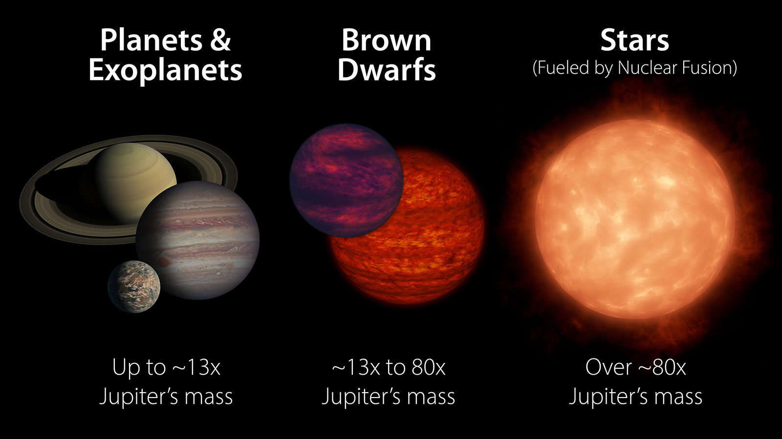
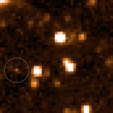
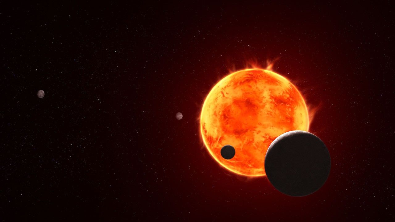
The Accident is a brown dwarf, a ball of gas that’s not quite a planet and not quite a star. Even among its already hard-to-classify peers, The Accident has a perplexing mix of physical features, some of which have been previously seen in only young brown dwarfs and others seen only in ancient ones. Because of those features, it slipped past typical detection methods before being discovered five years ago by a citizen scientist participating in Backyard Worlds: Planet 9. The program lets people around the globe look for new discoveries in data from NASA’s now-retired NEOWISE (Near-Earth Object Wide-field Infrared Survey Explorer), which was managed by NASA’s Jet Propulsion Laboratory in Southern California.
The Accident is so faint and odd that researchers needed NASA’s most powerful space observatory, Webb, to study its atmosphere. Among several surprises, they found evidence of a molecule they couldn’t initially identify. It turned out to be a simple silicon molecule called silane (SiH4). Researchers have long expected — but been unable — to find silane not only in our solar system’s gas giants, but also in the thousands of atmospheres belonging to brown dwarfs and to the gas giants orbiting other stars. The Accident is the first such object where this molecule has been identified.
Scientists are fairly confident that silicon exists in Jupiter and Saturn’s atmospheres but that it is hidden. Bound to oxygen, silicon forms oxides such as quartz that can seed clouds on hot gas giants, bearing a resemblance to dust storms on Earth. On cooler gas giants like Jupiter and Saturn, these types of clouds would sink far beneath lighter layers of water vapor and ammonia clouds, until any silicon-containing molecules are deep in the atmosphere, invisible even to the spacecraft that have studied those two planets up close.
Some researchers have also posited that lighter molecules of silicon, like silane, should be found higher up in these atmospheric layers, left behind like traces of flour on a baker’s table. That such molecules haven’t appeared anywhere except in a single, peculiar brown dwarf suggests something about the chemistry occurring in these environments.
“Sometimes it’s the extreme objects that help us understand what’s happening in the average ones,” said Faherty, a researcher at the American Museum of Natural History in New York City, and lead author on the new study.
Happy accident
Located about 50 light-years from Earth, The Accident likely formed 10 billion to 12 billion years ago, making it one of the oldest brown dwarfs ever discovered. The universe is about 14 billion years old, and at the time that The Accident developed, the cosmos contained mostly hydrogen and helium, with trace amounts of other elements, including silicon. Over eons, elements like carbon, nitrogen, and oxygen forged in the cores of stars, so planets and stars that formed more recently possess more of those elements.
Webb’s observations of The Accident confirm that silane can form in brown dwarf and planetary atmospheres. The fact that silane seems to be missing in other brown dwarfs and gas giant planets suggests that when oxygen is available, it bonds with silicon at such a high rate and so easily, virtually no silicon is left over to bond with hydrogen and form silane.
So why is silane in The Accident? The study authors surmise it is because far less oxygen was present in the universe when the ancient brown dwarf formed, resulting in less oxygen in its atmosphere to gobble up all the silicon. The available silicon would have bonded with hydrogen instead, resulting in silane.
“We weren’t looking to solve a mystery about Jupiter and Saturn with these observations,” said JPL’s Peter Eisenhardt, project scientist for the WISE (Wide-field Infrared Survey Explorer) mission, which was later repurposed as NEOWISE. “A brown dwarf is a ball of gas like a star, but without an internal fusion reactor, it gets cooler and cooler, with an atmosphere like that of gas giant planets. We wanted to see why this brown dwarf is so odd, but we weren’t expecting silane. The universe continues to surprise us.”
Brown dwarfs are often easier to study than gas giant exoplanets because the light from a faraway planet is typically drowned out by the star it orbits, while brown dwarfs generally fly solo. And the lessons learned from these objects extend to all kinds of planets, including ones outside our solar system that might feature potential signs of habitability.
“To be clear, we’re not finding life on brown dwarfs,” said Faherty. “But at a high level, by studying all of this variety and complexity in planetary atmospheres, we’re setting up the scientists who are one day going to have to do this kind of chemical analysis for rocky, potentially Earth-like planets. It might not specifically involve silicon, but they’re going to get data that is complicated and confusing and doesn’t fit their models, just like we are. They’ll have to parse all those complexities if they want to answer those big questions.”
More about WISE, Webb
A division of Caltech, JPL managed and operated WISE for NASA’s Science Mission Directorate. The mission was selected competitively under NASA’s Explorers Program managed by the agency’s Goddard Space Flight Center in Greenbelt, Maryland. The NEOWISE mission was a project of JPL and the University of Arizona in Tucson, supported by NASA’s Planetary Defense Coordination Office.
For more information about WISE, go to:
https://www.nasa.gov/mission_pages/WISE/main/index.html
The James Webb Space Telescope is the world’s premier space science observatory, and an international program led by NASA with its partners, ESA (European Space Agency) and CSA (Canadian Space Agency).
To learn more about Webb, visit:
https://science.nasa.gov/webb
News Media Contacts
Calla Cofield
Jet Propulsion Laboratory, Pasadena, Calif.
626-808-2469
calla.e.cofield@jpl.nasa.gov
Christine Pulliam
Space Telescope Science Institute, Baltimore, Md.
cpulliam@stsci.edi
2025-113
Keep Exploring
Discover Related Topics
Powered by WPeMatico
Get The Details…
Anthony Greicius