Snow Buries Kamchatka
It has been an eventful few months for the Northern Hemisphere atmosphere. An unusually early sudden stratospheric warming episode in late November appears to have factored into a weakened and distorted polar vortex at times in December, likely causing extra waviness in the polar jet stream. This helped fuel extensive intrusions of frigid air into the mid-latitudes, contributing to cold snaps in North America, Europe, and Asia, and priming the atmosphere for disruptive winter storms in January.
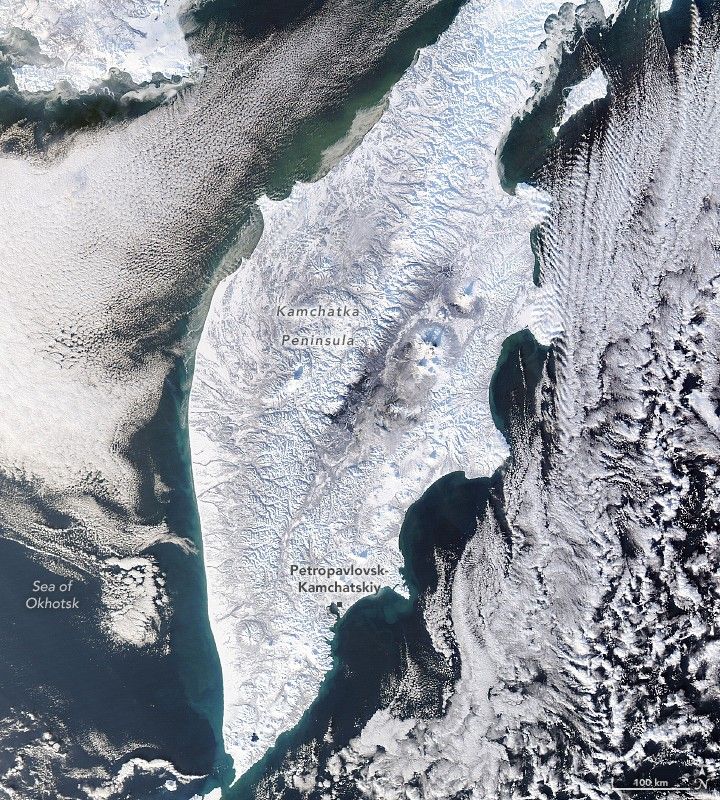
Russia’s Kamchatka Peninsula has been among the areas hit hard by cold and snowy weather in December and January. More than 2 meters (7 feet) of snow fell in the first two weeks of January, following 3.7 meters in December, according to news reports. Together, these totals make it one of the snowiest periods the peninsula has seen since the 1970s, according to Kamchatka’s Hydrometeorology Center. The onslaught brought Petropavlovsk-Kamchatsky, the regional capital, to a standstill, with reports of large snowdrifts burying cars and blocking access to buildings and infrastructure.
This image, acquired by the MODIS (Moderate Resolution Imaging Spectroradiometer) instrument on NASA’s Aqua satellite, shows fresh snow blanketing the peninsula’s rugged terrain on January 17, 2026. Several circular, snow-covered volcanic peaks are visible across the peninsula, one of the most volcanically active areas in the world. Petropavlovsk-Kamchatsky, home to more than 160,000 people, sits along Avacha Bay—a deep, sheltered bay formed by a combination of tectonic, volcanic, and glacial activity.
NASA Earth Observatory image by Lauren Dauphin, using MODIS data from NASA EOSDIS LANCE and GIBS/Worldview. Story by Adam Voiland.

References & Resources
- AccuWeather (2026, January 20) Snow buries Russia’s Kamchatka Peninsula, but don’t believe the AI videos. Accessed January 21, 2026.
- Cohen, J. (2026, January 19) Arctic Oscillation and Polar Vortex Blog. Accessed January 21, 2026.
- Manney, G. L., et al. (2022) What’s in a name? On the use and significance of the term “polar vortex.” Geophysical Research Letters, 49, e2021GL097617.
- The Moscow Times (2026, January 19) Kamchatka Struggles to Get Back on Its Feet a Week After Winter Storms Bury Peninsula. Accessed January 21, 2026.
- NASA (2024, January 30) Sudden Stratospheric Warming Event. Accessed January 21, 2026.
- Reuters (2026, January 21) Russia’s Far East Buried in Snow. Accessed January 21, 2026.
- UPI (2026, January 20) Snow buries Russia’s Kamchatka Peninsula. Accessed January 21, 2026.
- The Watchers (2026, January 18) State of Emergency declared for Petropavlovsk-Kamchatsky after extreme snow kills 2, Russia. Accessed January 21, 2026.
You may also be interested in:
Stay up-to-date with the latest content from NASA as we explore the universe and discover more about our home planet.

The peninsula in eastern Siberia features rugged terrain with towering, snow-covered peaks and cloud-filled valleys stretching between the Pacific Ocean…

Winds, waves, and ice near a remote town on the Chukchi Peninsula have sculpted a series of coastal inshore lagoons…

A short-lived storm dropped some of the largest accumulations in decades on Australia’s Northern Tablelands.


Powered by WPeMatico