Hail Yeah! NASA Researchers Use Volunteer Observations for Hail Estimates
The bigger the hailstone, the more damage it can cause. But scientists find that predicting hailstone size can be challenging. How quickly does hail melt as it falls?
Now, you can help tackle this question by joining the SouthEAst REgion CoCoRaHS Hail (SEaRCH) project. This network of backyard weather observers includes volunteers of all ages and backgrounds who work together to measure and report hail in their local communities. SEaRCH is also part of the NASA, National Oceanic and Atmospheric Association (NOAA), and National Science Foundationsupported Community Collaborative Rain, Hail, and Snow (CoCoRaHS) network, whose amateur weather sleuths report rain and snow.. These rain and snow observations are helping scientists better understand local variation in precipitation. CoCoRaHS data is regularly used by the National Weather Service, the Hydrologic Prediction Center, the U.S. Department of Agriculture, the National Drought Mitigation Center, broadcast meteorologists, research scientists, and more.
“I love the project, and I love being able to contribute meaningful data,” says Jeremy Kichler, a CoCoRaHS volunteer.
On June 14, 2023, Kichler witnessed a storm with hailstones ranging from 0.5 inches (12 mm) to two inches (51 mm) in diameter. The hailstones dented cars, damaged roof shingles, and shredded leaves across his neighborhood. After the storm, he submitted a CoCoRaHS hail report to notify the National Weather Service with photos and additional details about the hail.
NASA scientists are now using hail reports from volunteers like Kichler alongside archived satellite overpass data and newly developed hail melt profiles to model how hailstones of different sizes melt, once they fall below the freezing level.
To join volunteers like Jeremy Kichler and make hail reports of your own, all you need is your smartphone and the free CoCoRaHS mobile app. To make rain and snow reports, you’ll need a specific manual gauge approved by the National Weather Service. Find everything you need to get started in the CoCoRaHS and SEaRCH summary on the NASA Citizen Science website.) and the National Science Foundation.
CoCoRaHS hail photo submitted by volunteer Jeremy Kichler displaying a hand holding three large and uniquely shaped hailstones.
Credit Jeremy Kichler and CoCoRaHS
Map displaying data from the Special Sensor Microwave Imager/Sounder (SSMIS) satellite. Colors represent the probability of hail being detected (highest probability is dark red, least probability is light grey). Light blue, gray and light green pixels in the image indicate a storm over southern Georgia likely to contain hail. The black dot indicates the location of the hail reported to CoCoRaHS by Jeremy Kichler. The label “plus 10 min” indicates the satellite overpass occurred ten minutes before Jeremy’s observation of hail.
Data from the Special Sensor Microwave Imager/Sounder (SSMIS). Image processing by Sarah Bang.
Though Ireland is known for the many shades of green that grace its grassy pastoral landscapes, there’s one corner of the Emerald Isle where gray reigns supreme. In the Burren region, on the island’s west coast, what geologists describe as limestone pavement covers much of the rocky, treeless landscape.
The OLI (Operational Land Imager) on Landsat 8 captured this view of the Burren on May 16, 2025. The fossil-rich limestone that makes up the gray outcrops was deposited about 325 million years ago during the Carboniferous Period, when what is now Ireland lay near the equator beneath warm, shallow seas. Although the limestone was initially deposited in flat, horizontal layers on the seafloor, it later buckled into gentle arch- and trough-shaped folds as tectonic plates collided during a mountain-building episode known as the Variscan Orogeny.
These folds in the tilted rock layers and differences in their rate of erosion produced the terraced appearance that defines the Burren’s hills, with more erosion-resistant layers of rock persisting as ledges. Glacial activity also played a role in sculpting the landscape, scraping away soil and sediment to expose the limestone pavement and smoothing the region’s hills.
May 16, 2025
Limestone is prone to chemical weathering that produces an irregular terrain known as karst, pockmarked with sinkholes, caves, and fissures called grikes. Many grikes in the Burren collect soil and have become footholds where vegetation grows in the otherwise rocky landscape.
Individual grikes are too small to see in Landsat imagery, but networks of them have aligned along the rock layers, contributing to the concentric vegetation patterns visible in the image. Among the plants that you might find growing in them is the shamrock, the three-leaved clover that has become a symbol of Ireland.
With some luck, Trifolium dubium or Trifolium repens may even be found amidst the shamrock-shaped contours of Moneen Mountain, a 262-meter (860-foot) limestone hill visible in the image above. While there’s hardly consensus about what species is the true inspiration for shamrocks, these two clover species were among the favorites when Irish botanists were surveyed about the topic in the 1880s, according to the Carnegie Museum of Natural History.
NASA Earth Observatory images by Lauren Dauphin, using Landsat data from the U.S. Geological Survey.Story by Adam Voiland.
NASA Invites Media to Learn About Upcoming X-59 Test Flights
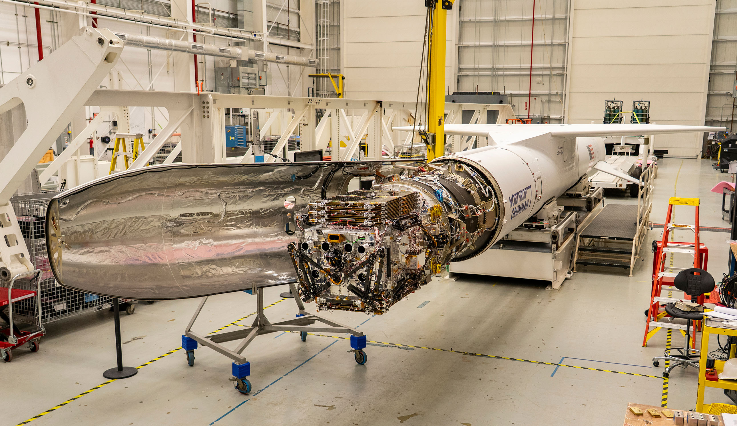
As its team prepared for second flight, NASA’s X-59 quiet supersonic aircraft underwent engine run testing on Thursday, March 12, 2026, at NASA’s Armstrong Flight Research Center in Edwards, California.
Credit: NASA
NASA will hold a media teleconference at 5:30 p.m. EDT on Thursday, March 19 to highlight plans for its X-59 quiet supersonic aircraft’s upcoming flight tests. The teleconference is set to take place after the X-59 is scheduled to complete its second flight, in California.
For the media call, NASA leadership will join representatives from the Quesst mission and contractor Lockheed Martin Skunk Works. The X-59’s test pilots will be available to answer questions about what it’s like to fly the aircraft and how they prepare for flights.
The news conference will stream on NASA’s YouTube channel. An instant replay will be available online. Learn how to watch NASA content on a variety of platforms, including social media.
Participants include:
Amit Kshatriya, NASA associate administrator
Cathy Bahm, project manager, Low Boom Flight Demonstrator, NASA’s Armstrong Flight Research Center, Edwards, California
Peter Coen, Quesst mission integration manager, NASA’s Langley Research Center, Hampton, Virginia
For second flight, the X-59 will taxi from its hangar at NASA Armstrong, then take off and land at nearby Edwards Air Force Base. The aircraft will fly for roughly an hour, reaching a cruising speed of 230 mph at 12,000 feet before accelerating to 260 mph at 20,000 feet.
This flight will kick off a series of flights known as envelope expansion, during which NASA will gradually take the X-59 faster and higher to ensure the aircraft’s safety and assess its performance. This phase will be followed by flights assessing the X-59’s unique acoustic profile. The X-59 is the centerpiece of NASA’s Quesst mission and was developed to fly supersonic, or faster than the speed of sound, without generating loud sonic booms.
Through Quesst, NASA is working to make commercial supersonic flight over land possible, dramatically reducing travel time in the United States or anywhere in the world.
This pair of images shows stars observed by the SPARCS (Star-Planet Activity Research CubeSat) space telescope simultaneously in the near-ultraviolet, left, and far-ultraviolet, right. These observations were recorded on Feb. 6, 2026, three weeks after the cube satellite, or CubeSat, launched aboard a SpaceX Falcon 9 on Jan. 11. The fact that one star is seen in the far-UV while multiple are seen in near-UV offers insights into the temperatures of these stars, with the one visible in both colors being the hottest.
Roughly the size of a large cereal box, SPARCS will monitor flares and sunspot activity on low-mass stars — objects only 30% to 50% the mass of the Sun. These stars are among the most common in the Milky Way and host the majority of the galaxy’s roughly 50 billion habitable-zone terrestrial planets, which are rocky worlds close enough to their stars for temperatures that could allow liquid water and potentially support life.
The SPARCS spacecraft is the first dedicated to continuously and simultaneously monitoring the far-ultraviolet and near-ultraviolet radiation from low-mass stars. Over its one-year mission, SPARCS will target approximately 20 low-mass stars and observe them over durations of five to 45 days.
Filters for the spacecraft’s camera, SPARCam, were made using a technique that improves sensitivity and performance by enabling them to be directly deposited onto the specially developed UV-sensitive “delta-doped” detectors. The approach of detector-integrated filters eliminated the need for a separate filter element, resulting in a system that is among the most sensitive of its kind ever flown in space.
The filters, detectors, and associated electronics were designed, fabricated, and tested at the Microdevices Laboratory (MDL) at NASA’s Jet Propulsion Laboratory in Southern California. Inventors at MDL harness physics, chemistry, and material science, including quantum, to deliver first-of-their-kind devices and capabilities for our nation.
Funded by NASA and led by Arizona State University in Tempe, SPARCS is managed under the agency’s Astrophysics Research and Analysis program. The agency’s CubeSat Launch Initiative (CSLI) selected SPARCS in 2022 for a ride to orbit. The initiative is a low-cost pathway for conducting scientific investigations and technology demonstrations in space, enabling students, teachers, and faculty to gain hands-on experience with flight hardware design, development, and building.
Blue Canyon Technologies fabricated the spacecraft bus.
To Protect Artemis II Astronauts, NASA Experts Keep Eyes on Sun
7 min read
To Protect Artemis II Astronauts, NASA Experts Keep Eyes on Sun
As four astronauts travel around the Moon on NASA’s Artemis II mission, they will venture beyond Earth’s protective magnetic field. The crew’s spacecraft, Orion, will carry and protect them as they journey into deep space and serves as the main protection against the Sun’s intense power. During their 10-day flight, NASA and the National Oceanic and Atmospheric Administration (NOAA) will monitor the Sun around the clock and translate space weather conditions into real-time decisions to protect the astronauts.
Space weather refers to the changing conditions driven by solar wind and eruptions from the Sun. Solar flares are the most powerful eruptions in the solar system, the strongest unleashing more energy than a billion hydrogen bombs. Coronal mass ejections are giant clouds of solar particles hundreds of times the size of Earth that burst from the Sun.
While both flares and coronal mass ejections can affect technology, the primary concern for astronauts is the solar particle events they can trigger, accelerating some particles to near light speed. If a significant solar particle event occurs near the Artemis II crew, it could raise radiation levels inside the spacecraft. Too high a total lifetime exposure can contribute to increased risks of developing cancer or health disorders that could impair cognition and performance. During the Artemis II mission, NASA will minimize that risk.
For the first time in half a century, four astronauts are leaving Earth’s protective magnetic field to enter a realm where massive solar eruptions can unleash more energy than a billion hydrogen bombs. The Artemis II crew will fly through a dangerous environment, but they’re not going it alone. On the voyage, the astronauts and their Orion capsule are outfitted with radiation trackers as ground teams monitor solar eruptions 24/7. Here’s how NASA and the National Oceanic and Atmospheric Administration (NOAA) are protecting explorers from the most powerful eruptions in the solar system. NASA/Joy Ng
Tracking solar eruptions
“Our focus will be real-time space weather analysis, prioritizing solar energetic particles and events that could produce them,” said Mary Aronne, operations lead for the space weather analysis office at NASA’s Goddard Space Flight Center in Greenbelt, Maryland. “We’re looking for the trigger, which would typically be a flare or a coronal mass ejection.”
This animation shows a solar eruption that produces a solar flare, a coronal mass ejection, and a flurry of energetic particles. The particles follow the spiral shape of the solar wind’s magnetic fields into interplanetary space.
NASA’s Goddard Space Flight Center Conceptual Image Lab
The Goddard team will track any solar eruptions that occur, measuring how big they are, how fast they’re moving, and how likely they are to generate energetic particles that will cross Orion’s path. To this end, they’ll use real-time data from Sun-watching spacecraft strategically placed across the solar system, such as NASA’s recently launched Interstellar Mapping and Acceleration Probe, NASA’s Solar Dynamics Observatory, the ESA (European Space Agency)/NASA Solar and Heliospheric Observatory, NOAA’s Geostationary Operational Environmental Satellites-19 satellite, and many others.
Other NASA spacecraft also will help monitor the Sun. Due to Mars’ current position, NASA’s Perseverance Mars rover can look at the far side of the Sun, where Earth has no view. The rover’s Mastcam-Z cameras can give NASA’s space weather teams a view of the largest sunspots up to two weeks earlier so the team can monitor and prepare for possible solar flares.
NASA’s Perseverance Rover captured these images of sunspots crossing the Sun from its vantage point on the Martian surface between February 24 – 27, 2026. Mars is currently on the opposite side of the Sun, giving the rover a view of sunspots not visible from Earth. Perseverance will monitor sunspots leading up to and during the Artemis II launch window, giving the Moon to Mars Space Weather Analysis Office (M2M SWAO) and Space Radiation Analysis Group (SRAG) teams advance notice of regions that could produce solar eruptions before they rotate onto the Earth-facing side of the Sun.
NASA/JPL-Caltech/ASU/MSSS/SSI
Monitoring crew exposure
Energetic solar particles don’t stream straight out from the Sun. They spiral along the Sun’s magnetic field lines, tracing loops tens of thousands of miles across and scattering due to particle collisions along the way. The chaotic swarm is so large that, from inside it, particles seem to be coming from every direction.
“It’s more like you’re sitting in a bathtub and it’s gradually filling with water,” said Stuart George, a space radiation analyst at NASA Johnson.
That gradual rise in radiation gives analysts time to evaluate the situation. Inside Orion, six radiation sensors, part of the Hybrid Electronic Radiation Assessor system designed and built by NASA, measure dose rates in different parts of the cabin. Artemis II astronauts also wear personal radiation trackers called crew active dosimeters. If radiation levels increase, Orion’s onboard systems display warnings accompanied by an audible alarm.
Artist’s concept of the components of the Orion spacecraft.
NASA
NASA has dosage level thresholds they’ll look for inside Orion. The first threshold signals a caution, prompting closer monitoring and coordination with medical and flight operations teams. A higher threshold triggers a recommendation for the crew to take shelter.
Radiation shielding in space is all about mass. Charged particles are slowed and absorbed as they pass through matter. Astronauts are trained to reconfigure their cabin during a solar particle event, removing stowed equipment from storage bays and securing it along areas of the cabin to add mass between themselves and incoming particles. Since Artemis II is the first crewed Artemis mission, testing this procedure in the Orion spacecraft is a major objective of the mission.
“Once crews add mass to the places that tend to be hotter in terms of radiation exposure, they can then continue to go about their duties,” George said.
Artist’s concept of the Trajectory for Artemis II, NASA’s first flight with crew aboard SLS and Orion to pave the way for long-term return to the Moon and missions to Mars.
NASA
The complexity of solar particle events is one reason NASA places spacecraft across the solar system. During a solar storm in January, NASA analysts tracked a coronal mass ejection on its way to Earth. When it arrived, satellites detected two distinct spikes in energetic particles where there would normally be one. Measurements from NASA’s BioSentinel CubeSat, deployed during the Artemis I mission, revealed what happened. The spacecraft, about 55 million miles away from Earth, detected a distinct eruption that later merged with the coronal mass ejection headed to Earth. Ultimately, two separate eruptions occurred.
The crew also must account for exposure to Earth’s radiation belts and galactic cosmic rays. The Van Allen Radiation Belts are two rings of high energy particles that surround our planet. Any mission headed to the Moon or farther must pass through them. Galactic cosmic rays are very high-energy particles from sources beyond our solar system. Together, the radiation exposure from these sources is expected to be comparable to a 1-month stay on the International Space Station, or about 5% of an astronaut’s career limit. Any exposure from solar radiation events would add to this baseline.
The Moon to Mars Space Weather Analysis Office, based at NASA Goddard, continuously assesses solar activity and any eruptions that occur. The team shares its analysis with the Space Radiation Analysis Group, based at NASA’s Johnson Space Center in Houston. Together, their forecasts and those from NOAA’s Space Weather Prediction Center, plus real-time measurements from inside the Orion spacecraft will inform recommendations for the flight control team.
By Miles Hatfield NASA’s Goddard Space Flight Center, Greenbelt, Md.