NASA Data Hackathon Inspires Community Action

NASA Data Hackathon Inspires Community Action

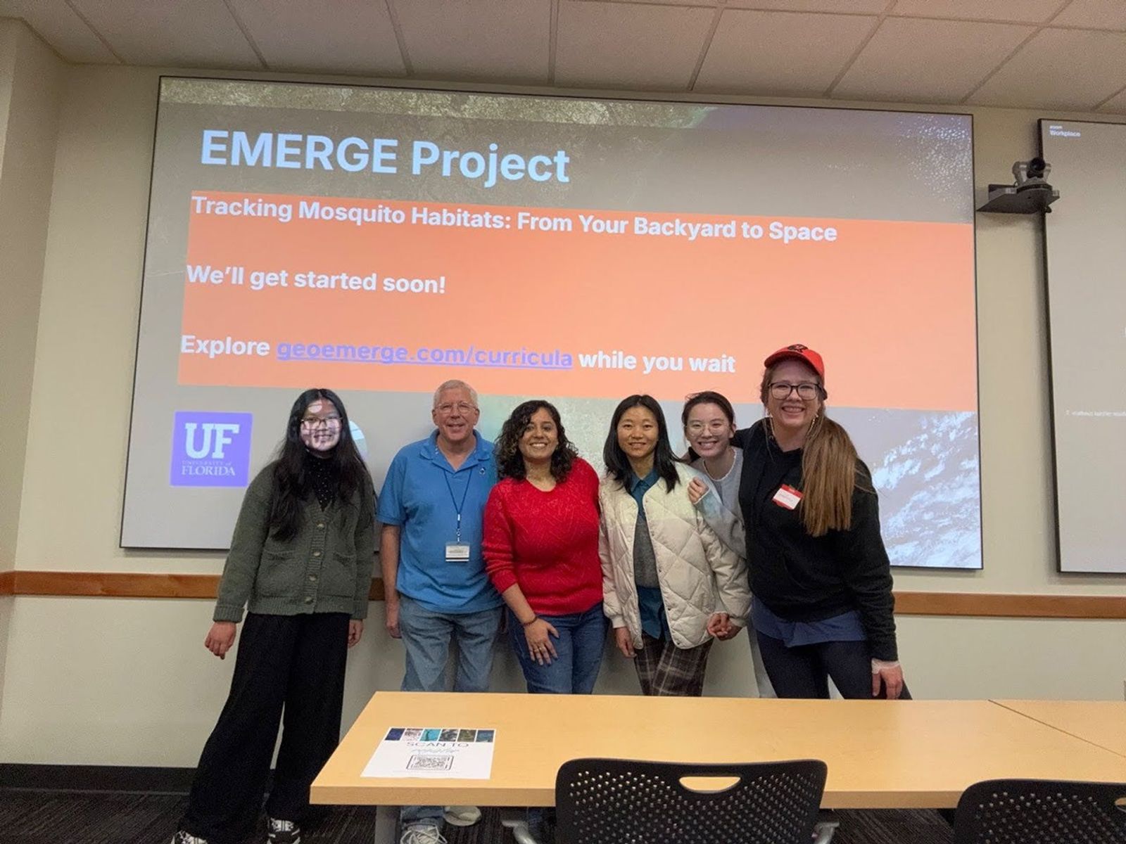
On Jan. 31, students, library staff, researchers, and community members gathered at the University of Florida’s (UF) Marston Science Library for the Environmental Monitoring through Education, Research, and Geospatial Engagement (EMERGE) NASA Data Hackathon. This initiative empowers libraries, educators, and individuals to engage in public health and environmental science using real-world data tools and citizen science. At the center of EMERGE is NASA’s Global Learning & Observations to Benefit the Environment (GLOBE) Observer app, which allows anyone with a smartphone to collect and explore data on mosquito habitats, land cover, clouds, and more.

From morning workshops to an end-of-day sprint, participants spent the day transforming real environmental data into maps, dashboards, infographics, and practical insights supporting public health and environmental decision-making. The event was hosted by the Geospatial Digital Informatics Lab (part of the Geography Department at UF), SciStarter (the world’s largest citizen science database), and Florida Community Innovation (a civic technology nonprofit), with support from NASA and UF Libraries.

The hackathon gave participants a chance to work directly with these volunteer-collected datasets and see how local observations connect to global research. Participants had access to a digital textbook created by the GeoDI Lab that explains how to download, process, visualize, and analyze GLOBE Observer data. At the hackathon, 13 teams came together to build projects analyzing GLOBE data or reenvisioning data collection for the app. You can explore the gallery of projects online here!

Celebrating Hackathon Winners

The following participants won honors in their categories.

APP IMPROVEMENT TRACK

Winner — Mosquito Tracker
Matheus Kunzler Maldaner
Hoang Anh Mai
Luana Kunzler Maldaner
Nicolas Murguia
Alfred Navarro

Honorable Mention — App Improvement Brief
Kelly Muma
Seth Paul

User Interface Recognition — GLOBE Observer, Simplified
Kaushal Thota
Sparsh Mogha

ADVANCED TRACK

Winner — Epidemiological Vector Mapping System
Aseel Ismail
Shreya Shanmugam
Devadarshini Dhandapani
Shivani Chandrasekar

Winner — GeoDude
Siddharth Nahar
Anushri N R
Avantika Holla
Matthew Losito

Honorable Mention — Mosquito Habitat Observations and Wildfire Hazard in Florida
Nancy Murphy
Philippa Burgess

Mapping Recognition — Mosquitos Worldwide Project
Ayesha Malligai M.

INTERMEDIATE TRACK

Winner — Swarm Sense
Isabella Bodea
Evan Mullins
Aashita Rai

Honorable Mention — Mosquito Risk Mapping
RamyaLakshmi KS
Delilah Penate
Thomas Barbato
Amit Rajpurkar

Data Analysis Recognition — Bias and Uncertainty in Reported Mosquito Habitat Data
Gabriel Dos Santos
Satyabrata Das
Matthew White
Dylan Aaron

BEGINNER TRACK

Winner — Beginner Track EMERGE Project
Breanna Blackwood
Demitri Tu
Masha Belyaeva
Elizabeth Nguyen
Tommy Lin

Honorable Mention — Mosquito Predicting with Globe Observer Data
Novaarcoid Rajpurkar

FIELD TRACK

Winner — Field Track Data Collection for Mosquito Habitat
Wei Liu
Yichan Li

How You Can Get Involved 

If you’re interested in civic tech, public-interest data, and community-centered research, you’re invited to get involved with Florida Community Innovation (FCI), one of the Hackathon partners. The FCI works year-round with students and community partners to build accessible tools, maps, and public resources and welcomes new collaborators from a wide range of backgrounds. Get started with FCI by visiting floridainnovation.org, and email info@floridainnovation.org to join one of their Wednesday meetings at 6 p.m. EDT to be matched with a project (like building games for Miami-Dade’s Recyclepedia app, helping create an AI tool for social workers in Orlando, and more).

Interested in shaping future EMERGE events? Apply to join a planning committee to help design the next hackathon! Committee members will help think through formats, tracks, accessibility, and community partnerships, with the goal of keeping future events welcoming, practical, and responsive to local needs. Organizers will receive a small honorarium. For more information, send an email to Caroline Nickerson: caroline.nickerson@floridainnovation.org

To start doing NASA science from your own neighborhood or backyard, you can also download the GLOBE Observer app! This app makes it possible for anyone to collect and explore data on mosquito habitats, land cover, and more!

The EMERGE program is made possible with the support of NASA through the Citizen Science Seed Funding Program, with the goal of enabling more scientists to develop and use citizen science techniques in their work.

From left: Olivia Zhang, Joe Aufmuth, Natya Hans, Yichan Li, Wei Liu, and Caroline Nickerson.
Caroline Nickerson

https://geoemerge.com/nasa-at-uf

Share

Details

Last Updated
Mar 23, 2026
Editor
NASA Science Editorial Team

Powered by WPeMatico

Get The Details…

Cargo Headed to Station, Week Begins with Science Prep and Maintenance

Cargo Headed to Station, Week Begins with Science Prep and Maintenance

ESA (European Space Agency) astronaut and Expedition 74 Flight Engineer Sophie Adenot is pictured inside the International Space Station's Harmony module during cargo stowage activities.
iss074e0333993 (Feb. 26, 2026) — ESA (European Space Agency) astronaut and Expedition 74 Flight Engineer Sophie Adenot is pictured inside the International Space Station’s Harmony module during cargo stowage activities.
ESA/Sophie Adenot

A cargo spacecraft is in orbit catching up to the International Space Station for a docking tomorrow to deliver food and supplies to the Expedition 74 crew. Aboard the orbital lab, the seven residents kicked off the week with science operations prep, routine maintenance, and getting systems ready for a future spacewalk.

In the morning, three NASA astronauts—Jessica Meir, Chris Williams, and Jack Hathaway—split up various duties. Meir conducted routine orbital plumbing and replaced a gas trap plug. Meanwhile, Williams relocated connection cables, set up and inserted canisters in the Cell Biology Experiment Facility, and consolidated food packages. Hathaway set his sights to spacesuit work, stowing batteries and performing a cooling loop scrub on the suits.

Meir and Williams then teamed up to review procedures and checklist items for an upcoming spacewalk. The duo was later joined by Hathaway and European Space Agency (ESA) astronaut Sophie Adenot to assemble the roll-out solar array mod kit struts, which will be installed to the exterior of the orbital lab during the upcoming spacewalk.

Before teaming up with her crewmates, Adenot completed a questionnaire, donned an actigraphy device, and collected biological samples for the RelaxPro experiment. The study tests relaxation training protocols in flight, which could contribute to the development of measures to reduce stress and behavioral risks for astronauts on future space missions. Adenot then moved into the Kibo module, where she retrieved and swapped in new cartridges to the Electrostatic Levitation Furnace.

In the Roscosmos segment, two cosmonauts are monitoring and gearing up for the arrival of the Progress 94 cargo spacecraft tomorrow. Progress, loaded with nearly three tons of food, fuel, and supplies, launched from the Baikonur Cosmodrome in Kazakhstan at 7:59 a.m. EDT March 22. The cargo spacecraft is set to dock to the space-facing port of the station’s Poisk module tomorrow, March 24, at 9:34 a.m. NASA’s live rendezvous and docking coverage will begin at 8:45 a.m. on NASA+Amazon Prime, and the agency’s YouTube channel. 

Commander Sergey Kud-Sverchkov and flight engineer Sergei Mikaev teamed up to configure and complete training on TORU, the Telerobotically Operated Rendezvous System, which is a control panel located in the Zvezda Service Module. One of the two antennas used for an automated rendezvous and docking did not deploy after separation. Progress will arrive 200 meters from the space station autonomously, then transition to manual piloting for its final approach. Kud-Sverchkov will manually pilot the spacecraft through TORU for rendezvous and docking at the space station’s Poisk module.

Mikaev then moved on to audit stowage, equipment, and hardware throughout the Roscosmos segment. Meanwhile, flight engineer Andrey Fedyaev charged camera batteries, conducted orbital plumbing, then backed up and sent exercise data to ground teams for analysis.

Learn more about station activities by following the space station blog@space_station on X, as well as the ISS Facebook and ISS Instagram accounts.

Get the latest from NASA delivered every week. Subscribe here.

Powered by WPeMatico

Get The Details…

Abby Graf

Science Through Shadows: How Astronomical Alignments Reveal the Universe

Science Through Shadows: How Astronomical Alignments Reveal the Universe

6 min read

Science Through Shadows: How Astronomical Alignments Reveal the Universe

When one celestial object passes in front of another, it can cast a shadow that travels across space – and sometimes across Earth. These moments of alignment, known as eclipses, occultations, and transits, allow scientists to study distant objects in remarkable ways. By observing how light changes when an object briefly blocks another, astronomers can measure sizes and shapes, detect atmospheres, and refine the orbits of asteroids and planets.

3 panel image showing the moment of totality during the total solar eclipse in 2024, a computer generated rocky asteroid occulting a distant star, and a the dark disk of a planet transiting across a yellow star
From left to right: Image of the total solar eclipse of 2024, an asteroid occulting a distant star, and an exoplanet transiting a star.

The Science Through Shadows project, funded by NASA’s Science Activation program and led by Fiske Planetarium at the University of Colorado Boulder, explores how these shadow-based events help scientists conduct astronomical research. The project has produced a series of short films that explain the science behind eclipses, occultations, and solar observations while highlighting the people who help make these discoveries possible – including students, educators, and volunteer citizen scientists.

The videos are designed for use in classrooms, libraries, planetariums, and informal learning environments, and are available free of charge in both English and Spanish. Versions are available in 2D formats for streaming and classroom use, as well as fulldome formats for planetariums worldwide.

Explore the seven films currently available: 

Ring of Fire Eclipse

Focus: The annular solar eclipse of October 14, 2023
On October 14, 2023, observers across North America experienced an annular solar eclipse, sometimes called a “ring of fire.” During an annular eclipse, the Moon passes directly in front of the Sun but appears slightly smaller in the sky, leaving a bright ring of sunlight visible around its edges.

This video explains how annular eclipses differ from total solar eclipses, explores the science behind these events, and highlights safe viewing practices. It also helps viewers understand what makes eclipse observations both scientifically valuable and deeply memorable experiences.

Total Eclipse of the Sun

Focus: The total solar eclipse of April 8, 2024
A total solar eclipse is one of the most dramatic astronomical events visible from Earth. On April 8, 2024, millions of people across North America had the opportunity to witness the Moon completely block the Sun, revealing the Sun’s faint outer atmosphere, known as the corona.

This video explores what happens during a total solar eclipse, why traveling to the path of totality offers a dramatically different experience, and how scientists use eclipses to study the Sun’s atmosphere.

What Causes Eclipses?

Focus: The science behind eclipses

Why don’t eclipses happen every month? What conditions must occur for the Sun, Earth, and Moon to align?

This episode explains the orbital mechanics that produce eclipses and clarifies the differences between solar and lunar eclipses. By addressing common misconceptions, it helps viewers understand the celestial alignments that create these spectacular events.

Chasing Polymele’s Shadow

Focus: The Lucy occultation campaign

When an asteroid passes in front of a distant star, it briefly blocks the star’s light, casting a shadow across Earth. Astronomers call this event an occultation, and it can reveal valuable information about the asteroid’s size, shape, and surrounding environment.

This video follows the Lucy Occultation Project, where scientists and citizen scientists worked together to observe the Trojan asteroid Polymele ahead of NASA’s Lucy mission flyby. On February 3, 2023, more than 100 telescopes across two continents were deployed to capture the moment Polymele passed in front of a star. The resulting observations help scientists better understand the asteroid before the spacecraft’s encounter.

Humanity Touches the Sun

Focus: NASA’s Parker Solar Probe

NASA’s Parker Solar Probe is helping scientists explore the Sun closer than ever before. On December 24, 2024, the spacecraft made its closest approach to the Sun, traveling more than 430,000 miles per hour – faster than any human-made object.

This video explores how Parker Solar Probe studies the Sun’s outer atmosphere and helps scientists investigate long-standing questions about the solar corona and solar wind.

The Sun Touches Humanity

Focus: NASA’s PUNCH mission

NASA’s PUNCH (Polarimeter to Unify the Corona and Heliosphere) mission provides a new way to observe how the Sun influences space throughout the inner solar system.

Consisting of four suitcase-sized satellites in low-Earth orbit, PUNCH creates global, three-dimensional observations of the region between the Sun and Earth. These measurements help scientists better understand how the solar wind forms and evolves, and how solar storms travel through space.

Eclipse Participatory Science

Focus: Citizen science during recent solar eclipses

Solar eclipses create powerful opportunities for collaborative scientific research. This episode follows two large participatory science projects that took place during recent North American eclipses: the Nationwide Eclipse Ballooning Project, another NASA Science Activation-funded project that’s led by Montana State University, and Citizen CATE 2024, a NASA- and National Science Foundation-supported observing campaign.

Through balloon launches, telescope observations, and hands-on engineering challenges, students, educators, and volunteers collected atmospheric and solar data that scientists are now analyzing. The episode highlights how people with curiosity and passion can contribute meaningfully to real scientific discovery.

2D versions of these videos in both English and Spanish can be found on Fiske Planetarium’s YouTube channel, and downloadable versions are available through the project’s distribution page. Fulldome masters (1K, 2K, and 4K) are also available for free download via the Fiske Productions page, allowing planetariums around the world to share these stories of discovery with their audiences.

Through projects like Science Through Shadows, NASA’s Science Activation program helps connect everyone, everywhere with NASA Science content, experts, and opportunities to participate. Whether observing an eclipse, tracking an asteroid’s shadow, or studying data from a spacecraft, these moments of alignment offer powerful opportunities to explore how the universe works – and how people everywhere can participate in the process of discovery.

NASA Citizen Science

Everyone, everywhere – regardless of country of origin or citizenship status – can collaborate with professional scientists, conduct cutting-edge science, and make real discoveries as a volunteer for NASA Citizen Science projects. These projects give participants the opportunity to collaborate with professional scientists, conduct cutting-edge science, and make real discoveries related to NASA’s five research divisions: Earth science, planetary science, astrophysics, biological and physical sciences, and heliophysics. Explore available projects and get started: https://science.nasa.gov/citizen-science/

Share

Details

Last Updated
Mar 23, 2026

Powered by WPeMatico

Get The Details…

See NASA’s GUARDIAN Catch a Tsunami

See NASA’s GUARDIAN Catch a Tsunami

This animation shows how, following a massive earthquake off Russia on July 29, 2025, GUARDIAN flagged an incoming wave west of Hawaii some 32 minutes before it made landfall and was detected by tide gauges (shown in blue). Credit: NASA’s Scientific Visualization Studio

A new data visualization illustrates how an experimental NASA technology can provide extra lead time to communities in the path of a tsunami. Called GUARDIAN (GNSS Upper Atmospheric Real-time Disaster Information and Alert Network), the software detects slight distortions in satellite navigation signals to spot hazards on the move..

The animation breaks down a real-life case study: last summer’s massive Kamchatka earthquake and the tsunami that it sent racing across the Pacific and towards Hawaii at over 500 mph (805 kph).

The visualization shows the magnitude 8.8 earthquake (seen in purple) strike off the Russian coast on July 29, 2025, triggering the tsunami. The red, orange, yellow, and green ringlets represent real-time readings from ground stations tracking GPS and other navigational satellite signals. The disturbances were spotted by GUARDIAN’s artificial intelligence-powered detection algorithms as soon as eight minutes after the earthquake.

For the next several hours, signs of the tsunami were picked up by GUARDIAN across the Pacific Ocean in near real time. The system flagged an incoming wave off the coast of Kauai some 32 minutes before it made landfall and was detected by tide gauges (shown in blue).

The results highlight GUARDIAN’s potential to augment existing early warning systems, said Camille Martire, one of its developers at NASA’s Jet Propulsion Laboratory in Southern California.

Currently, determining whether an earthquake generated a tsunami remains a challenge. Forecasters rely on seismic data and computer simulations to make their best prediction, then wait for pressure sensors attached to the ocean floor to confirm a passing wave. Those sensors work well but are expensive and thinly dispersed. Gaps in coverage remain. And in those gaps, warning time disappears.

The GUARDIAN approach is complementary and cost effective because it monitors existing data from GPS and other constellations that make up the Global Navigation Satellite System. It’s also free to access, though for now best suited to analysts trained to interpret its findings.

How GUARDIAN works

All day, every day, geopositioning constellations transmit radio signals to ground stations around the globe. On the ground, the data is refined to sub-decimeter (less than 10 centimeters) positioning accuracy by JPL’s Global Differential GPS System. Before the signals get there, however, they must travel through an electrically charged skin of plasma called the ionosphere.

Solar storms and other space weather can wreak electrical mayhem in the ionosphere, and so can events on Earth. Tsunamis and earthquakes, by displacing large amount of air at Earth’s surface, unleash pressure waves that can slightly perturb the radio signals coming down from satellites. While systems are in place to correct for this “noise,” GUARDIAN considers it a useful signal.

Currently, GUARDIAN scours data from more than 350 GNSS ground stations around the Pacific Ring of Fire, a hotbed for the ocean’s deadliest waves. And the system is not confined to tsunamis. Earthquakes, volcanic eruptions, missile tests, spacecraft reentries, meteoroid splashdowns — anything that produces a large rumble on Earth is potentially fair game. While the Kamchatka event didn’t cause widespread damage to people or property, it showed how the next time disaster strikes, NASA science could give communities a few more minutes to act.

GUARDIAN is being developed at JPL by the GDGPS project, which is partially supported by NASA’s Space Geodesy Project.

To learn more, visit: https://guardian.jpl.nasa.gov/

Media Contacts

Andrew Wang / Andrew Good
Jet Propulsion Laboratory, Pasadena, Calif.
626-379-6874 / 818-393-2433
andrew.wang@jpl.nasa.gov / andrew.c.good@jpl.nasa.gov

Written by Sally Younger

2026-017

Powered by WPeMatico

Get The Details…
Naomi Hartono

SWOT Mission Unlocks a New View of Our Waterways

SWOT Mission Unlocks a New View of Our Waterways

1 min read

SWOT Mission Unlocks a New View of Our Waterways

Explore how rivers move, change, and sustain life across the planet.

Using data from the SWOT (Surface Water and Ocean Topography) mission, jointly developed by the NASA/JPL and the Centre National d’Études Spatiales with contributions from the Canadian Space Agency and the United Kingdom Space Agency, scientists can now measure rivers continuously and across the entire globe for the first time in human history.

From the Mississippi River to the Amazon, these observations reveal how rivers flow, how they change over time, and how they support ecosystems, economies, and communities worldwide like never before.

Share

Details

Last Updated
Mar 23, 2026
Editor
Earth Science Division Editorial Team

Powered by WPeMatico

Get The Details…