NASA Relaunches Mentor-Protégé Program to Fill Supply Chain Gaps

NASA Relaunches Mentor-Protégé Program to Fill Supply Chain Gaps
A yellow and blue star logo stands next to text that reads "Office of Small Business Mentor-Protégé Program."
Credit: NASA

In an effort to grow new commercial markets that support the future of space exploration, scientific discovery, and aeronautics research, NASA is preparing to relaunch its Mentor-Protégé Program for contractors on Friday, Nov. 1.

The program originally was launched to encourage NASA prime contractors, or mentors, to enter into agreements with eligible small businesses, or protégés. These agreements were created to enhance the protégés’ performance on NASA contracts and subcontracts, foster the establishment of long-term business relationships between small businesses and NASA prime contractors, and increase the overall number of small businesses that receive NASA contracts and subcontract awards.

“The NASA Mentor-Protégé Program is a critical enabling tool that allows experienced companies to provide business developmental assistance to emerging firms,” said Dwight Deneal, assistant administrator for NASA’s Office of Small Business Programs (OSBP). “The program enables NASA to expand its industrial base of suppliers, as prime and subcontractors, to assist in executing the mission and programs throughout the agency.”

The program’s relaunch follows an assessment of its policies and procedures by OSBP to ensure it continues to support NASA’s missions and addresses any supply chain gaps at an optimal level.

To provide more information about the program and its relaunch, OSBP will host an online lunch and learn event on Thursday, Nov. 7, at 1:00 p.m. EST. The event is open to all current and potential mentors and protégés who want to learn more about changes in the program, qualifications to participate, and how to apply.

“We are excited about rolling out the enhanced NASA Mentor-Protégé Program,” said David Brock, lead small business specialist for OSBP. “The program’s new focus will allow large businesses to mentor smaller firms in key areas that align with NASA’s mission and opportunities within the agency’s supply chain.”

One key change expands eligibility to all small businesses, in addition to minority-serving institutions, including Historically Black Colleges and Universities, and Ability One entities. This expansion enables the program to support an inclusive environment for more small businesses and underserved communities to interact with NASA and its contractors.

The program also will focus on engaging businesses within a select number of North American Industry Classifications System (NAICS) codes and specific industry sectors, such as research and development and aerospace manufacturing. These adjustments will allow the program to better support NASA’s long-term strategic goals and mission success.

The program is designed to benefit both the mentor and the protégé by fostering productive networking and contract opportunities. In a mentor-protégé agreement, mentors build relationships with small businesses, developing a subcontracting base and accruing credit toward their small business subcontracting goals. In addition, protégés receive technical and developmental assistance while also gaining sole-source contracts from mentors and additional contracting opportunities.

NASA is responsible for the administration and management of each agreement. The OSBP oversees the program and conducts semi-annual performance reviews to monitor progress and accomplishments made as a result of the mentor-protégé agreement.

To apply to be a mentor, companies must be a current NASA prime contractor with an approved small business contracting plan. Companies also must be eligible for the receipt of government contracts and be categorized under certain NAICS codes. Potential protégés must certify as a small business within NAICS size standards.

Find more information about participating in NASA’s Mentor-Protégé Program at:

https://www.nasa.gov/osbp/mentor-protege-program

Share

Details

Last Updated

Oct 29, 2024

Powered by WPeMatico

Get The Details…
Tiernan P. Doyle
New NASA Instrument for Studying Snowpack Completes Airborne Testing

New NASA Instrument for Studying Snowpack Completes Airborne Testing

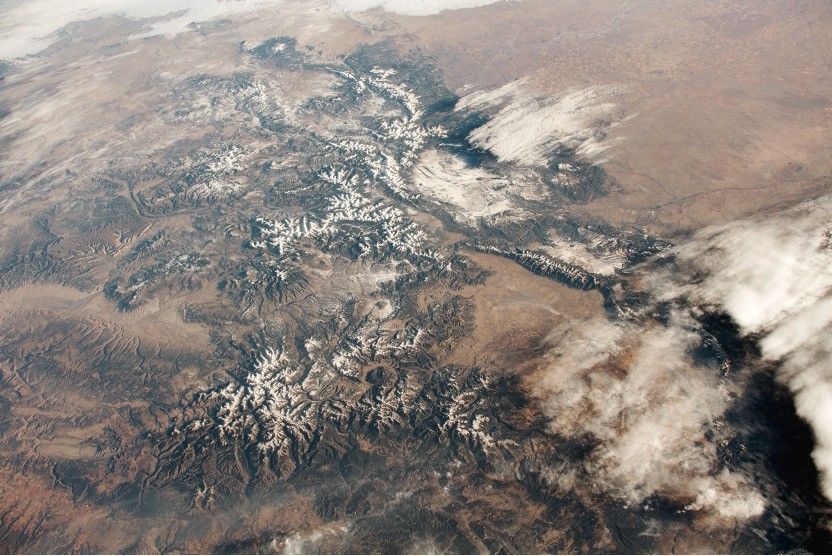
Aerial view of brown mountains with white snow-covered tops
The Rocky Mountains in Colorado, as seen from the International Space Station. Snowmelt from the mountainous western United States is an essential natural resource, making up as much as 75% of some states’ annual freshwater supply.

Summer heat has significant effects in the mountainous regions of the western United States. Melted snow washes from snowy peaks into the rivers, reservoirs, and streams that supply millions of Americans with freshwater—as much as 75% of the annual freshwater supply for some states.

But as climate change brings winter temperatures to new highs, these summer rushes of freshwater can sometimes slow to a trickle.

“The runoff supports cities most people wouldn’t expect,” explained Chris Derksen, a glaciologist and Research Scientist with Environment and Climate Change Canada. “Big cities like San Francisco and Los Angeles get water from snowmelt.”

To forecast snowmelt with greater accuracy, NASA’s Earth Science Technology Office (ESTO) and a team of researchers from the University of Massachusetts, Amherst, are developing SNOWWI, a dual-frequency synthetic aperture radar that could one day be the cornerstone of future missions dedicated to measuring snow mass on a global scale – something the science community lacks.

SNOWWI aims to fill this technology gap. In January and March 2024, the SNOWWI research team passed a key milestone, flying their prototype for the first time aboard a small, twin-engine aircraft in Grand Mesa, Colorado, and gathering useful data on the area’s winter snowfields.

“I’d say the big development is that we’ve gone from pieces of hardware in a lab to something that makes meaningful data,” explained Paul Siqueira, professor of engineering at the University of Massachusetts, Amherst, and principal investigator for SNOWWI.

SNOWWI stands for Snow Water-equivalent Wide Swath Interferometer and Scatterometer. The instrument probes snowpack with two Ku-band radar signals: a high-frequency signal that interacts with individual snow grains, and a low-frequency signal that passes through the snowpack to the ground. 

The high-frequency signal gives researchers a clear look at the consistency of the snowpack, while the low-frequency signal helps researchers determine its total depth.

“Having two frequencies allows us to better separate the influence of the snow microstructure from the influence of the snow depth,” said Derksen, who participated in the Grand Mesa field campaign. “One frequency is good, two frequencies are better.”

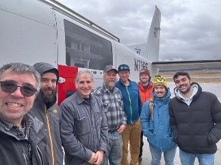
A group of people in winter clothes standing beside a mid-sized airplane.

The SNOWWI team in Grand Mesa, preparing to flight test their instrument. From an altitude of 4 kilometers (2.5 miles), SNOWWI can map 100 square kilometers (about 38 square miles) in just 30 minutes.

As both of those scattered signals interact with the snowpack and bounce back towards the instrument, they lose energy. SNOWWI measures that lost energy, and researchers later correlate those losses to features within the snowpack, especially its depth, density, and mass.

From an airborne platform with an altitude of 2.5 miles (4 kilometers), SNOWWI could map 40 square miles (100 square kilometers) of snowy terrain in just 30 minutes. From space, SNOWWI’s coverage would be even greater. Siqueira is working with Capella Space to develop a space-ready SNOWWI for satellite missions.

But there’s still much work to be done before SNOWWI visits space. Siqueira plans to lead another field campaign, this time in the mountains of Idaho. Grand Mesa is relatively flat, and Siqueira wants to see how well SNOWWI can measure snowpack tucked in the folds of complex, asymmetrical terrain.

For Derksen, who spends much of his time quantifying the freshwater content of snowpack in Canada, having a reliable database of global snowpack measurements would be game-changing.

“Snowmelt is money. It has intrinsic economic value,” he said. “If you want your salmon to run in mountain streams in the spring, you must have snowmelt. But unlike other natural resources, at this time, we really can’t monitor it very well.”

For information about opportunities to collaborate with NASA on novel, Earth-observing instruments, see ESTO’s catalog of open solicitations with its Instrument Incubator Program here.

Project Leads: Dr. Paul Siqueira, University of Massachusetts (Principal Investigator); Hans-Peter Marshall, University of Idaho (Co-Investigator)

Sponsoring Organizations: NASA’s Earth Science Technology Office (ESTO), Instrument Incubator Program (IIP)

Powered by WPeMatico

Get The Details…

Gateway: Centering Science

Gateway: Centering Science

3 min read

Preparations for Next Moonwalk Simulations Underway (and Underwater)

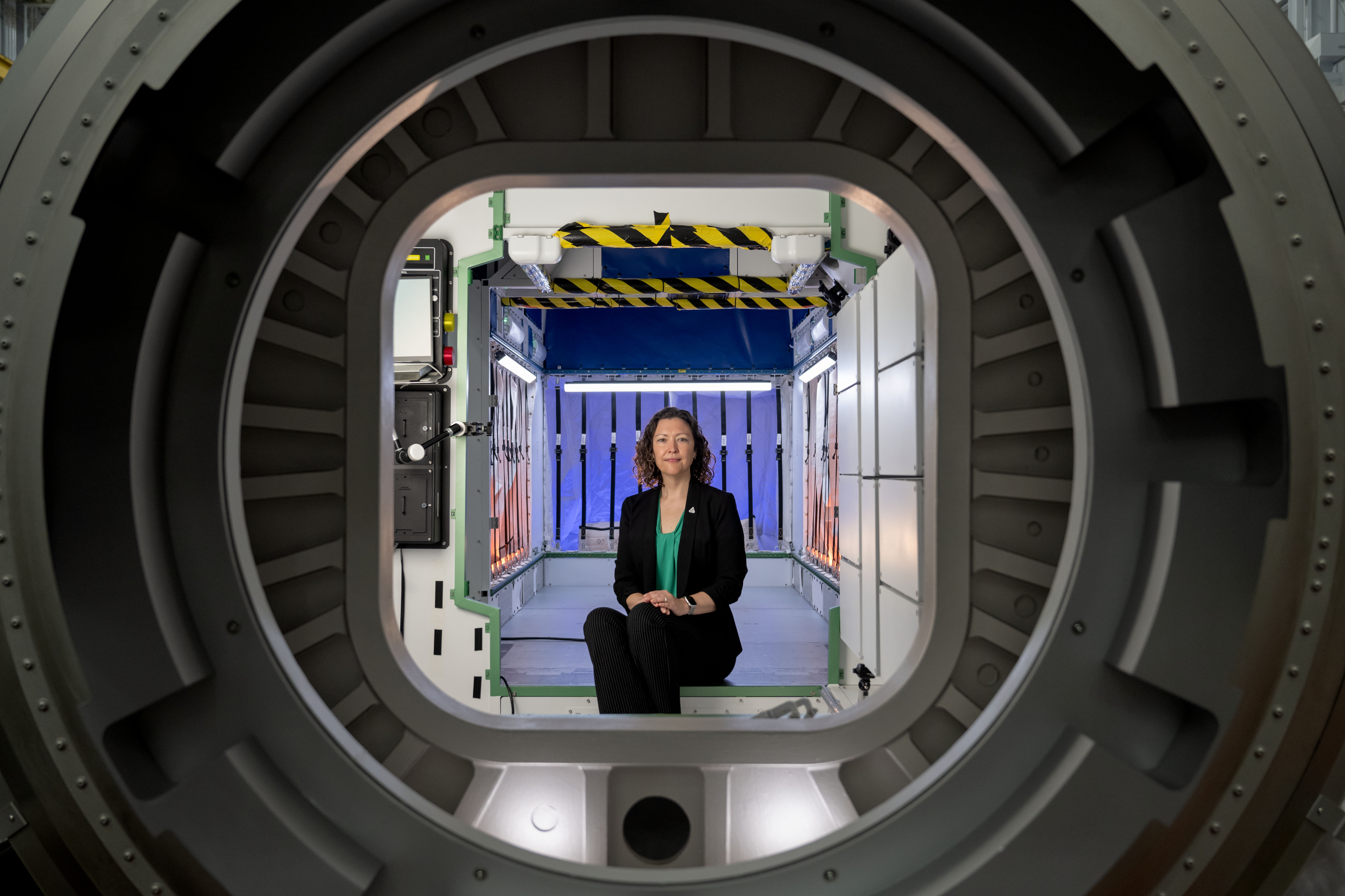
Stephanie Dudley, Gateway's mission integration and utilization manager, sits inside a high-fidelity mockup of HALO (Habitation and Logistics Outpost) at NASA’s Johnson Space Center. She is framed by a docking port, with interior components visible behind her.The mockup’s design showcases the compact and functional environment Artemis astronauts will use for living, conducting experiments, and preparing for lunar surface missions. Photo credit: NASA/Josh Valcarcel
Stephanie Dudley, Gateway’s mission integration and utilization manager, sits inside a high-fidelity HALO (Habitation and Logistics Outpost) mockup at NASA’s Johnson Space Center.
NASA/Josh Valcarcel

Stephanie Dudley sits at the intersection of human spaceflight and science for Gateway, humanity’s first lunar space station that will host astronauts and unique scientific investigations.

Gateway’s mission integration and utilization manager, Dudley recently posed for this photo in a high-fidelity mockup of the space station’s HALO (Habitation and Logistics Outpost), where astronauts will live, conduct science, and prepare for missions to investigate the lunar South Pole region. Dudley works with NASA’s partner space agencies and academia to identify science opportunities on Gateway.

HALO will host various science experiments, including the Heliophysics Environmental and Radiation Measurement Experiment Suite, led by NASA, and the Internal Dosimeter Array, led by ESA (European Space Agency) and JAXA (Japan Aerospace Exploration Agency). The heliophysics experiment will fly on HALO’s exterior, and the dosimeter will be housed inside Gateway in a series of racks, mockups of which are shown to the right of Dudley in the image above. Both experiments will study solar and cosmic radiation to help the science community better understand how to protect astronauts and hardware during deep space travels to places like Mars.

“We are building [Gateway] for a 15-year lifespan, but definitely hope that we go longer than that,” Dudley recently said on Houston We Have a Podcast. “And so that many years of scientific study in a place where humans have never worked and lived long-term, Gateway is going to allow us to do that.”

Dudley pulls double duty as a deputy director for the Exploration Operations Office within NASA’s Moon to Mars Program, a role that connects her to Artemis science beyond Gateway, including science investigations on the Orion and Human Landing System spacecraft and lunar terrain vehicle.

“My work…is helping to make sure that across all of the six [Artemis] programs, including Gateway, we’re all focusing on utilization in the same way,” Dudley said.

Dudley’s team coordinates science payloads for Artemis II, the first mission to send humans to the Moon since 1972, and Artemis III, the first landing in the lunar South Pole region that is of keen interest to the global science community.

Gateway’s HALO will launch with the space station’s Power and Propulsion Element ahead of the Artemis IV mission in 2028, the first lunar mission to include an orbiting space station.

“Gateway sounds so science fiction, but it’s real,” Dudley recently said. “And we’re building it. And in a few years, it’s going to be around the Moon and that’s when the real work, the fun work in my opinion, is going to begin and science will never be the same.”

Gateway is humanity’s first lunar space station as a central component of the Artemis campaign that will return humans to the Moon for scientific discovery and chart a path for the first human missions to Mars.

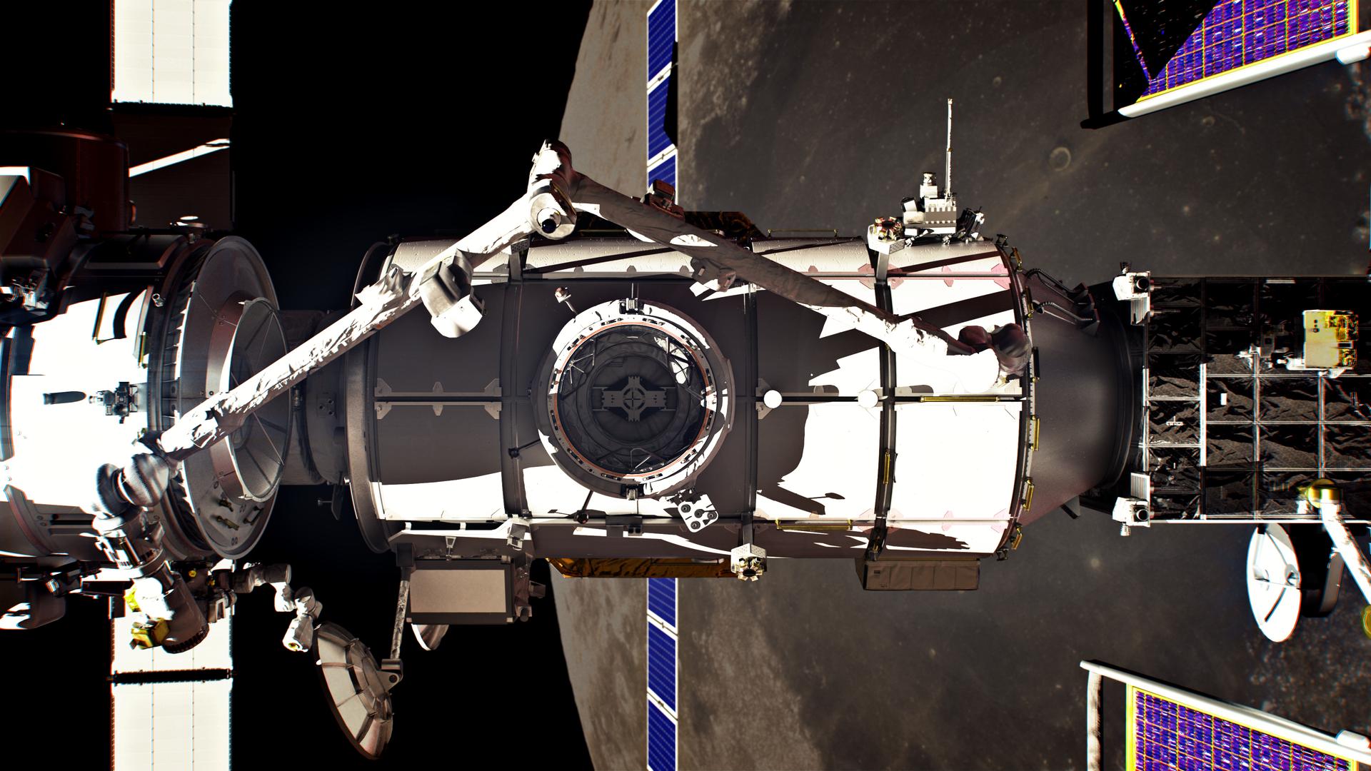
A close-up view of Gateway’s Habitation and Logistics Outpost (HALO) module at the Thales Alenia Space facility in Turin, Italy. The image captures the intricate internal structure of the cylindrical module, highlighting its framework and the interior. The module is positioned horizontally, with light casting dramatic shadows.
Gateway’s HALO (Habitation and Logistics Outpost), one of four Gateway modules where astronauts will live, conduct science and prepare for lunar surface missions.
Thales Alenia Space
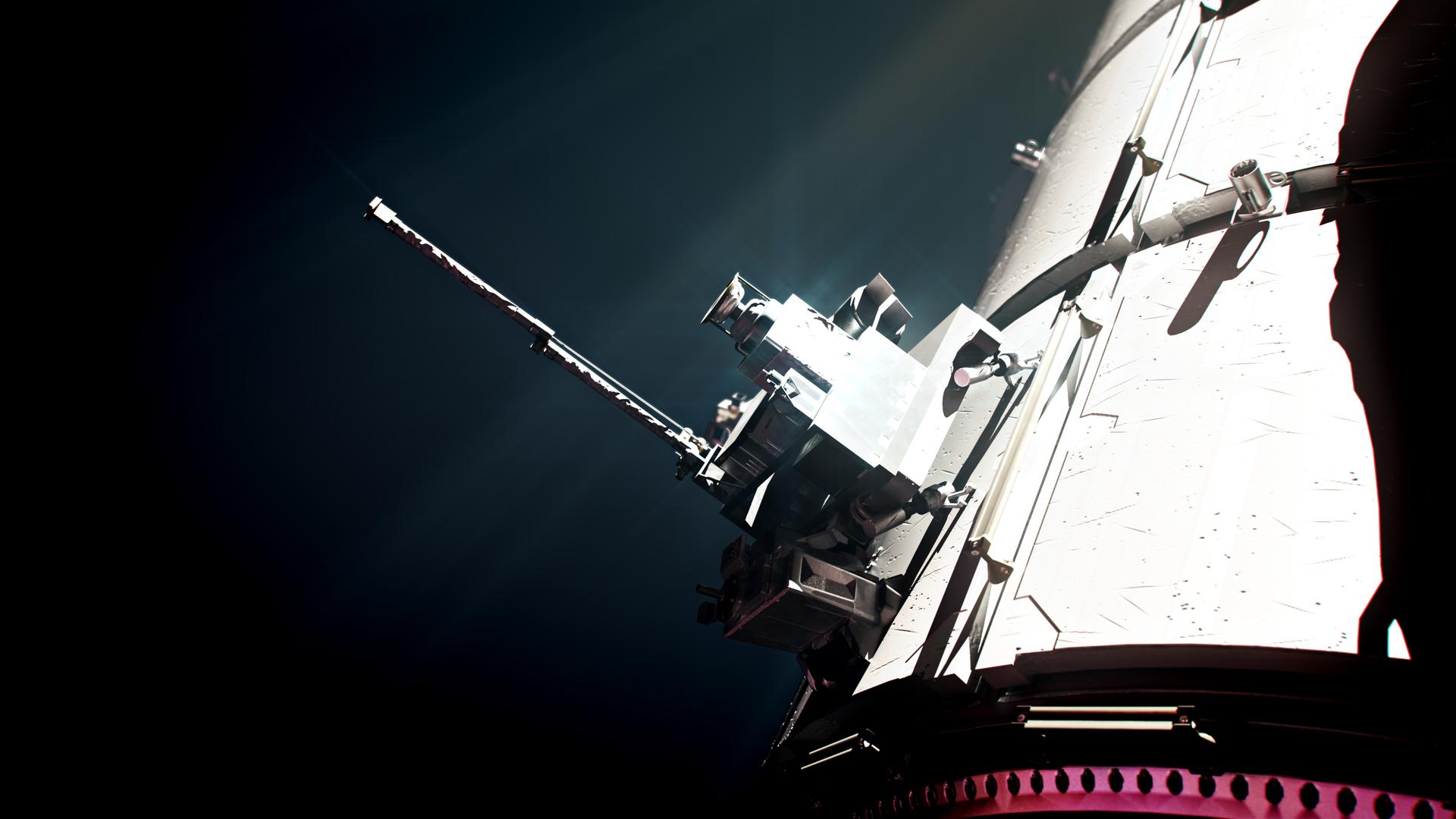
An artist’s rendering of the Heliophysics Environmental and Radiation Measurement Experiment Suite, or HERMES, one of the three Gateway science experiments that will study solar and cosmic radiation.
NASA
An artist’s rendering of HALO in lunar orbit. The HERMES science experiment is shown on the top right corner of the space station element.
NASA/Alberto Bertolin, Bradley Reynolds

Powered by WPeMatico

Get The Details…
Dylan Connell

Sols 4345-4347: Contact Science is Back on the Table

Sols 4345-4347: Contact Science is Back on the Table

3 min read

Sols 4345-4347: Contact Science is Back on the Table

A grayscale photograph of the Martian surface shows a wide plain covered in sharp rocks, extending to the left and right edges of the frame, and far into the distance, all in shades of light gray. On either side of this channel, smoother hillsides rise at about 45 degree angles, and off on the horizon are an even higher range of hills. Those are much brighter gray, with dark areas, resembling the singed meringue peaks atop a lemon pie.
NASA’s Mars rover Curiosity acquired this image using its Right Navigation Camera on sol 4343 — Martian day 4,343 of the Mars Science Laboratory mission — on Oct. 24, 2024 at 15:26:28 UTC.
NASA/JPL-Caltech

Earth planning date: Friday, Oct. 25, 2024

The changes to the plan Wednesday, moving the drive a sol earlier, meant that we started off planning this morning about 18 meters (about 59 feet) farther along the western edge of Gediz Vallis and with all the data we needed for planning. This included the knowledge that once again one of Curiosity’s wheels was perched on a rock. Luckily, unlike on Wednesday, it was determined that it was safe to still go ahead with full contact science for this weekend. This consisted of two targets “Mount Brewer” and “Reef Lake,” two targets on the top and side of the same block.

Aside from the contact science, Curiosity has three sols to fill with remote imaging. The first two sols include “targeted science,” which means all the imaging of specific targets in our current workspace. Then, after we drive away on the second sol, we fill the final sol of the plan with “untargeted science,” where we care less about knowing exactly where the rover is ahead of time. A lot of the environmental team’s (or ENV) activities fall under this umbrella, which is why our dedicated “ENV Science Block” (about 30 minutes of environmental activities one morning every weekend) tends to fall at the end of a weekend plan. 

But that’s getting ahead of myself. The weekend plan starts off with two ENV activities — a dust devil movie and a suprahorizon cloud movie. While cloud movies are almost always pointed in the same direction, our dust devil movie has to be specifically targeted. Recently we’ve been looking southeast toward a more sandy area (which you can see above), to see if we can catch dust lifting there. After those movies we hand the reins back over to the geology team (or GEO) for ChemCam observations of Reef Lake and “Poison Meadow.” Mastcam will follow this up with its own observations of Reef Lake and the AEGIS target from Wednesday’s plan. The rover gets some well-deserved rest before waking up for the contact science I talked about above, followed by a late evening Mastcam mosaic of “Fascination Turret,” a part of Gediz Vallis ridge that we’ve seen before. 

We’re driving away on the second sol, but before that we have about another hour of science. ChemCam and Mastcam both have observations of “Heaven Lake” and the upper Gediz Vallis ridge, and ENV has a line-of-sight observation, to see how much dust is in the crater, and a pre-drive deck monitoring image to see if any dust moves around on the rover deck due to either driving or wind. Curiosity gets a short nap before a further drive of about 25 meters (about 82 feet). 

The last sol of the weekend is a ChemCam special. AEGIS will autonomously choose a target for imaging, and then ChemCam has a passive sky observation to examine changing amounts of atmospheric gases. The weekend doesn’t end at midnight, though — we wake up in the morning for the promised morning ENV block, which we’ve filled with two cloud movies, another line-of-sight, and a tau observation to see how dusty the atmosphere is.

Written by Alex Innanen, Atmospheric Scientist at York University

Share

Details

Last Updated
Oct 28, 2024

Related Terms

Powered by WPeMatico

Get The Details…

Planets Beware: NASA Unburies Danger Zones of Star Cluster

Planets Beware: NASA Unburies Danger Zones of Star Cluster

In the Cygnus OB2 star cluster, giant stars send out large amounts of high-energy radiation that can disrupt relatively fragile disks of dust and gas that are in the process of coalescing to form new planets. These images show NASA's Chandra X-ray Observatory data detailing the diffuse X-ray emission and young stars, with infrared data from NASA's Spitzer Space Telescope revealing young stars and the cooler dust and gas throughout the region. These data were used to create the best census of young stars in the cluster.
X-ray: NASA/CXC/SAO/J. Drake et al, IR: NASA/JPL-Caltech/Spitzer; Image Processing: NASA/CXC/SAO/N. Wolk

Most stars form in collections, called clusters or associations, that include very massive stars. These giant stars send out large amounts of high-energy radiation, which can disrupt relatively fragile disks of dust and gas that are in the process of coalescing to form new planets.

A team of astronomers used NASA’s Chandra X-ray Observatory, in combination with ultraviolet, optical, and infrared data, to show where some of the most treacherous places in a star cluster may be, where planets’ chances to form are diminished.

The target of the observations was Cygnus OB2, which is the nearest large cluster of stars to our Sun — at a distance of about 4,600 light-years. The cluster contains hundreds of massive stars as well as thousands of lower-mass stars. The team used long Chandra observations pointing at different regions of Cygnus OB2, and the resulting set of images were then stitched together into one large image.

The deep Chandra observations mapped out the diffuse X-ray glow in between the stars, and they also provided an inventory of the young stars in the cluster. This inventory was combined with others using optical and infrared data to create the best census of young stars in the cluster.

In this new composite image, the Chandra data (purple) shows the diffuse X-ray emission and young stars in Cygnus OB2, and infrared data from NASA’s now-retired Spitzer Space Telescope (red, green, blue, and cyan) reveals young stars and the cooler dust and gas throughout the region.

In these crowded stellar environments, copious amounts of high-energy radiation produced by stars and planets are present. Together, X-rays and intense ultraviolet light can have a devastating impact on planetary disks and systems in the process of forming.

Planet-forming disks around stars naturally fade away over time. Some of the disk falls onto the star and some is heated up by X-ray and ultraviolet radiation from the star and evaporates in a wind. The latter process, known as “photoevaporation,” usually takes between 5 and 10 million years with average-sized stars before the disk disappears. If massive stars, which produce the most X-ray and ultraviolet radiation, are nearby, this process can be accelerated.

The researchers using this data found clear evidence that planet-forming disks around stars indeed disappear much faster when they are close to massive stars producing a lot of high-energy radiation. The disks also disappear more quickly in regions where the stars are more closely packed together.

For regions of Cygnus OB2 with less high-energy radiation and lower numbers of stars, the fraction of young stars with disks is about 40%. For regions with more high-energy radiation and higher numbers of stars, the fraction is about 18%. The strongest effect — meaning the worst place to be for a would-be planetary system — is within about 1.6 light-years of the most massive stars in the cluster.

A separate study by the same team examined the properties of the diffuse X-ray emission in the cluster. They found that the higher-energy diffuse emission comes from areas where winds of gas blowing away from massive stars have collided with each other. This causes the gas to become hotter and produce X-rays. The less energetic emission probably comes from gas in the cluster colliding with gas surrounding the cluster.

Two separate papers describing the Chandra data of Cygnus OB2 are available. The paper about the planetary danger zones, led by Mario Giuseppe Guarcello (National Institute for Astrophysics in Palermo, Italy), appeared in the November 2023 issue of the Astrophysical Journal Supplement Series, and is available here. The paper about the diffuse emission, led by Juan Facundo Albacete-Colombo (University of Rio Negro in Argentina) was published in the same issue of Astrophysical Journal Supplement, and is available here.

NASA’s Marshall Space Flight Center in Huntsville, Alabama, manages the Chandra program. The Smithsonian Astrophysical Observatory’s Chandra X-ray Center controls science operations from Cambridge, Massachusetts, and flight operations from Burlington, Massachusetts.

JPL managed the Spitzer Space Telescope mission for NASA’s Science Mission Directorate in Washington until the mission was retired in January 2020. Science operations were conducted at the Spitzer Science Center at Caltech. Spacecraft operations were based at Lockheed Martin Space in Littleton, Colorado. Data are archived at the Infrared Science Archive operated by IPAC at Caltech. Caltech manages JPL for NASA.

Read more from NASA’s Chandra X-ray Observatory.

Learn more about the Chandra X-ray Observatory and its mission here:

https://www.nasa.gov/chandra

https://chandra.si.edu

Visual Description

This release features a composite image of the Cygnus OB2 star cluster, which resembles a night sky blanketed in orange, purple, and grey clouds.

The center of the square image is dominated by purple haze. This haze represents diffuse X-ray emissions, and young stars, detected by the Chandra X-ray observatory. Surrounding the purple haze is a mottled, streaky, brick orange cloud. Another cloud resembling a tendril of grey smoke stretches from our lower left to the center of the image. These clouds represent relatively cool dust and gas observed by the Spitzer Space Telescope.

Although the interwoven clouds cover most of the image, the thousands of stars within the cluster shine through. The lower-mass stars present as tiny specks of light. The massive stars gleam, some with long refraction spikes.

News Media Contact

Megan Watzke
Chandra X-ray Center
Cambridge, Mass.
617-496-7998
mwatzke@cfa.harvard.edu

Lane Figueroa
Marshall Space Flight Center, Huntsville, Alabama
256-544-0034
lane.e.figueroa@nasa.gov

Powered by WPeMatico

Get The Details…
Lee Mohon