NASA’s James Webb Space Telescope recently imaged the Sombrero Galaxy with its NIRCam (Near-Infrared Camera), which shows dust from the galaxy’s outer ring blocking stellar light from stars within the galaxy. In the central region of the galaxy, the roughly 2,000 globular clusters, or collections of hundreds of thousands of old stars held together by gravity, glow in the near-infrared. The Sombrero Galaxy is around 30 million light-years from Earth in the constellation Virgo. From Earth, we see this galaxy nearly “edge-on,” or from the side.
NASA, ESA, CSA, STScI
After capturing an image of the iconic Sombrero galaxy at mid-infrared wavelengths in late 2024, NASA’s James Webb Space Telescope has now followed up with an observation in the near-infrared. In the newest image, released on June 3, 2025, the Sombrero galaxy’s tightly packed group of stars at the galaxy’s center is illuminated while the dust in the outer edges of the disk blocks some stellar light. Studying galaxies like the Sombrero at different wavelengths, including the near-infrared and mid-infrared with Webb, as well as the visible with NASA’s Hubble Space Telescope, helps astronomers understand how this complex system of stars, dust, and gas formed and evolved, along with the interplay of that material.
NASA Mars Orbiter Captures Volcano Peeking Above Morning Cloud Tops
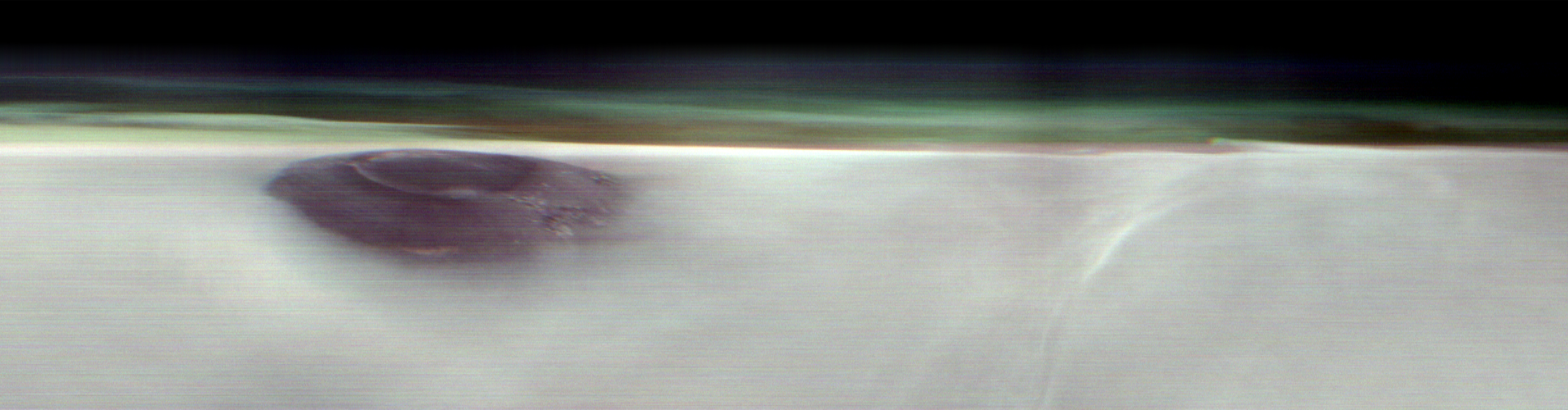
Arsia Mons, an ancient Martian volcano, was captured before dawn on May 2, 2025, by NASA’s 2001 Mars Odyssey orbiter while the spacecraft was studying the Red Planet’s atmosphere, which appears here as a greenish haze.
NASA/JPL-Caltech/ASU
The 2001 Odyssey spacecraft captured a first-of-its-kind look at Arsia Mons, which dwarfs Earth’s tallest volcanoes.
A new panorama from NASA’s 2001 Mars Odyssey orbiter shows one of the Red Planet’s biggest volcanoes, Arsia Mons, poking through a canopy of clouds just before dawn. Arsia Mons and two other volcanoes form what is known as the Tharsis Montes, or Tharsis Mountains, which are often surrounded by water ice clouds (as opposed to Mars’ equally common carbon dioxide clouds), especially in the early morning. This panorama marks the first time one of the volcanoes has been imaged on the planet’s horizon, offering the same perspective of Mars that astronauts have of the Earth when they peer down from the International Space Station.
Launched in 2001, Odyssey is the longest-running mission orbiting another planet, and this new panorama represents the kind of science the orbiter began pursuing in 2023, when it captured the first of its now four high-altitude images of the Martian horizon. To get them, the spacecraft rotates 90 degrees while in orbit so that its camera, built to study the Martian surface, can snap the image.
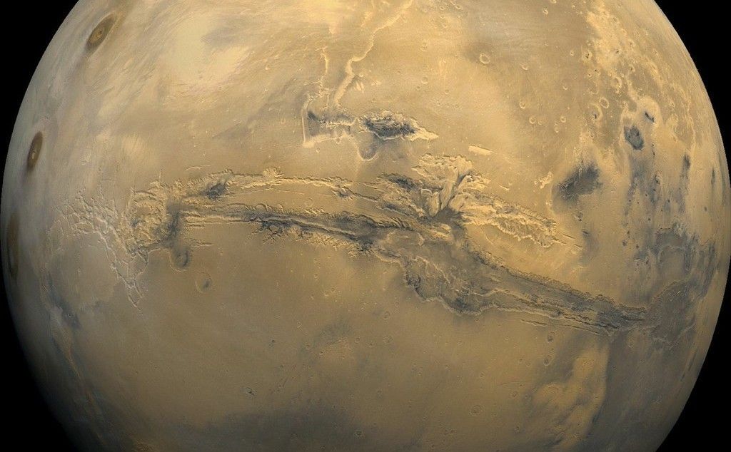
Arsia Mons is the southernmost of the three volcanoes that make up Tharsis Montes, shown in the center of this cropped topographic map of Mars. Olympus Mons, the solar system’s largest volcano, is at upper left. The western end of Valles Marineris begins cutting its wide swath across the planet at lower right.
NASA/JPL-Caltech
The angle allows scientists to see dust and water ice cloud layers, while the series of images enables them to observe changes over the course of seasons.
“We’re seeing some really significant seasonal differences in these horizon images,” said planetary scientist Michael D. Smith of NASA’s Goddard Space Flight Center in Greenbelt, Maryland. “It’s giving us new clues to how Mars’ atmosphere evolves over time.”
Understanding Mars’ clouds is particularly important for understanding the planet’s weather and how phenomena like dust storms occur. That information, in turn, can benefit future missions, including entry, descent and landing operations.
Volcanic Giants
While these images focus on the upper atmosphere, the Odyssey team has tried to include interesting surface features in them, as well. In Odyssey’s latest horizon image, captured on May 2, Arsia Mons stands 12 miles (20 kilometers) high, roughly twice as tall as Earth’s largest volcano, Mauna Loa, which rises 6 miles (9 kilometers) above the seafloor.
The southernmost of the Tharsis volcanoes, Arsia Mons is the cloudiest of the three. The clouds form when air expands as it blows up the sides of the mountain and then rapidly cools. They are especially thick when Mars is farthest from the Sun, a period called aphelion. The band of clouds that forms across the planet’s equator at this time of year is called the aphelion cloud belt, and it’s on proud display in Odyssey’s new panorama.
“We picked Arsia Mons hoping we would see the summit poke above the early morning clouds. And it didn’t disappoint,” said Jonathon Hill of Arizona State University in Tempe, operations lead for Odyssey’s camera, called the Thermal Emission Imaging System, or THEMIS.
The THEMIS camera can view Mars in both visible and infrared light. The latter allows scientists to identify areas of the subsurface that contain water ice, which could be used by the first astronauts to land on Mars. The camera can also image Mars’ tiny moons, Phobos and Deimos, allowing scientists to analyze their surface composition.
More About Odyssey
NASA’s Jet Propulsion Laboratory, a division of Caltech in Pasadena, California, manages the Mars Odyssey Project for the agency’s Science Mission Directorate in Washington as part of NASA’s Mars Exploration Program portfolio. Lockheed Martin Space in Denver built the spacecraft and collaborates with JPL on mission operations. THEMIS was built and is operated by Arizona State University in Tempe.
NASA’s Ready-to-Use Dataset Details Land Motion Across North America
A new online portal by NASA and the Alaska Satellite Facility maps satellite radar meas-urements across North America, enabling users to track land movement since 2016 caused by earthquakes, landslides, volcanoes, and other phenomena.
USGS
An online tool maps measurements and enables non-experts to understand earthquakes, subsidence, landslides, and other types of land motion.
NASA is collaborating with the Alaska Satellite Facility in Fairbanks to create a powerful web-based tool that will show the movement of land across North America down to less than an inch. The online portal and its underlying dataset unlock a trove of satellite radar measurements that can help anyone identify where and by how much the land beneath their feet may be moving — whether from earthquakes, volcanoes, landslides, or the extraction of underground natural resources such as groundwater.
Spearheaded by NASA’s Observational Products for End-Users from Remote Sensing Analysis (OPERA) project at the agency’s Jet Propulsion Laboratory in Southern California, the effort equips users with information that would otherwise take years of training to produce. The project builds on measurements from spaceborne synthetic aperture radars, or SARs, to generate high-resolution data on how Earth’s surface is moving.
Formally called the North America Surface Displacement Product Suite, the new dataset comes ready to use with measurements dating to 2016, and the portal allows users to view those measurements at a local, state, and regional scales in a few seconds. For someone not using the dataset or website, it could take days or longer to do a similar analysis.
“You can zoom in to your country, your state, your city block, and look at how the land there is moving over time,” said David Bekaert, the OPERA project manager and a JPL radar scientist. “You can see that by a simple mouse click.”
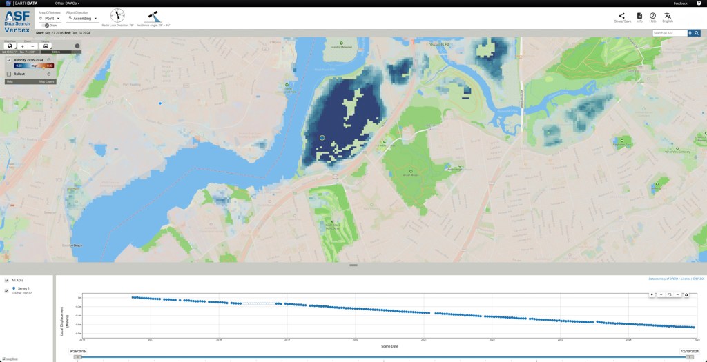
The portal currently includes measurements for millions of pixels across the U.S. Southwest, northern Mexico, and the New York metropolitan region, each representing a 200-foot-by-200-foot (60-meter-by-60-meter) area on the ground. By the end of 2025, OPERA will add data to cover the rest of the United States, Central America, and Canada within 120 miles (200 kilometers) of the U.S. border. When a user clicks on a pixel, the system pulls measurements from hundreds of files to create a graph visualizing the land surface’s cumulative movement over time.
The OPERA portal shows how land is sinking in Freshkills Park, which is being built on the site of a former landfill on Staten Island, New York. Landfills tend to sink over time as waste decomposes and settles. The blue dot marks the spot where the portal is showing movement in the graph.
Alaska Satellite Facility
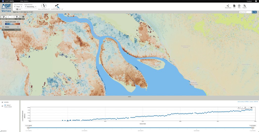
Land is rising at the Colorado River’s outlet to the Gulf of California, as indicated in this screenshot from the OPERA portal. The uplift is due to the sediment from the river building up over time. The graph shows that the land at the blue dot has risen about 8 inches (20 centimeters) since 2016.
Alaska Satellite Facility
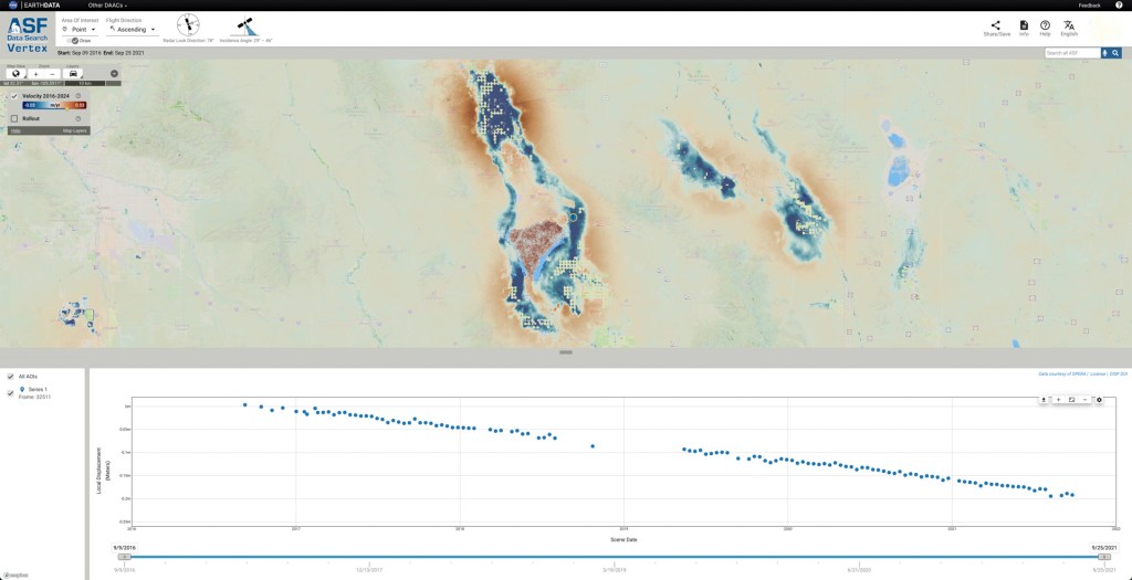
The OPERA portal shows that land near Willcox, Arizona, subsided about 8 inches (20 centimeters) since between 2016 and 2021, in large part due to groundwater pumping. The region is part of an area being managed by state water officials.
Alaska Satellite Facility
“The OPERA project automated the end-to-end SAR data processing system such that users and decision-makers can focus on discovering where the land surface may be moving in their areas of interest,” said Gerald Bawden, program scientist responsible for OPERA at NASA Headquarters in Washington. “This will provide a significant advancement in identifying and understanding potential threats to the end users, while providing cost and time savings for agencies.”
For example, water-management bureaus and state geological surveys will be able to directly use the OPERA products without needing to make big investments in data storage, software engineering expertise, and computing muscle.
How It Works
To create the displacement product, the OPERA team continuously draws data from the ESA (European Space Agency) Sentinel-1 radar satellites, the first of which launched in 2014. Data from NISAR, the NASA-ISRO (Indian Space Research Organisation) Synthetic Aperture Radar mission, will be added to the mix after that spacecraft launches later this year.
Satellite-borne radars work by emitting microwave pulses at Earth’s surface. The signals scatter when they hit land and water surfaces, buildings, and other objects. Raw data consists of the strength and time delay of the signals that echo back to the sensor.
To understand how land in a given area is moving, OPERA algorithms automate steps in an otherwise painstaking process. Without OPERA, a researcher would first download hundreds or thousands of data files, each representing a pass of the radar over the point of interest, then make sure the data aligned geographically over time and had precise coordinates.
Then they would use a computationally intensive technique called radar interferometry to gauge how much the land moved, if at all, and in which direction — towards the satellite, which would indicate the land rose, or away from the satellite, which would mean it sank.
“The OPERA project has helped bring that capability to the masses, making it more accessible to state and federal agencies, and also users wondering, ‘What’s going on around my house?’” said Franz Meyer, chief scientist of the Alaska Satellite Facility, a part of the University of Alaska Fairbanks Geophysical Institute.
Monitoring Groundwater
Sinking land is a top priority to the Arizona Department of Water Resources. From the 1950s through the 1980s, it was the main form of ground movement officials saw, as groundwater pumping increased alongside growth in the state’s population and agricultural industry. In 1980, the state enacted the Groundwater Management Act, which reduced its reliance on groundwater in highly populated areas and included requirements to monitor its use.
The department began to measure this sinking, called subsidence, with radar data from various satellites in the early 2000s, using a combination of SAR, GPS-based monitoring, and traditional surveying to inform groundwater-management decisions.
Now, the OPERA dataset and portal will help the agency share subsidence information with officials and community members, said Brian Conway, the department’s principal hydrogeologist and supervisor of its geophysics unit. They won’t replace the SAR analysis he performs, but they will offer points of comparison for his calculations. Because the dataset and portal will cover the entire state, they also could identify areas not yet known to be subsiding.
“It’s a great tool to say, ‘Let’s look at those areas more intensely with our own SAR processing,’” Conway said.
The displacement product is part of a series of data products OPERA has released since 2023. The project began in 2020 with a multidisciplinary team of scientists at JPL working to address satellite data needs across different federal agencies. Through the Satellite Needs Working Group, those agencies submitted their requests, and the OPERA team worked to improve access to information to aid a range of efforts such as disaster response, deforestation tracking, and wildfire monitoring.
NASA Provides Hardware for Space Station DNA Repair Experiment
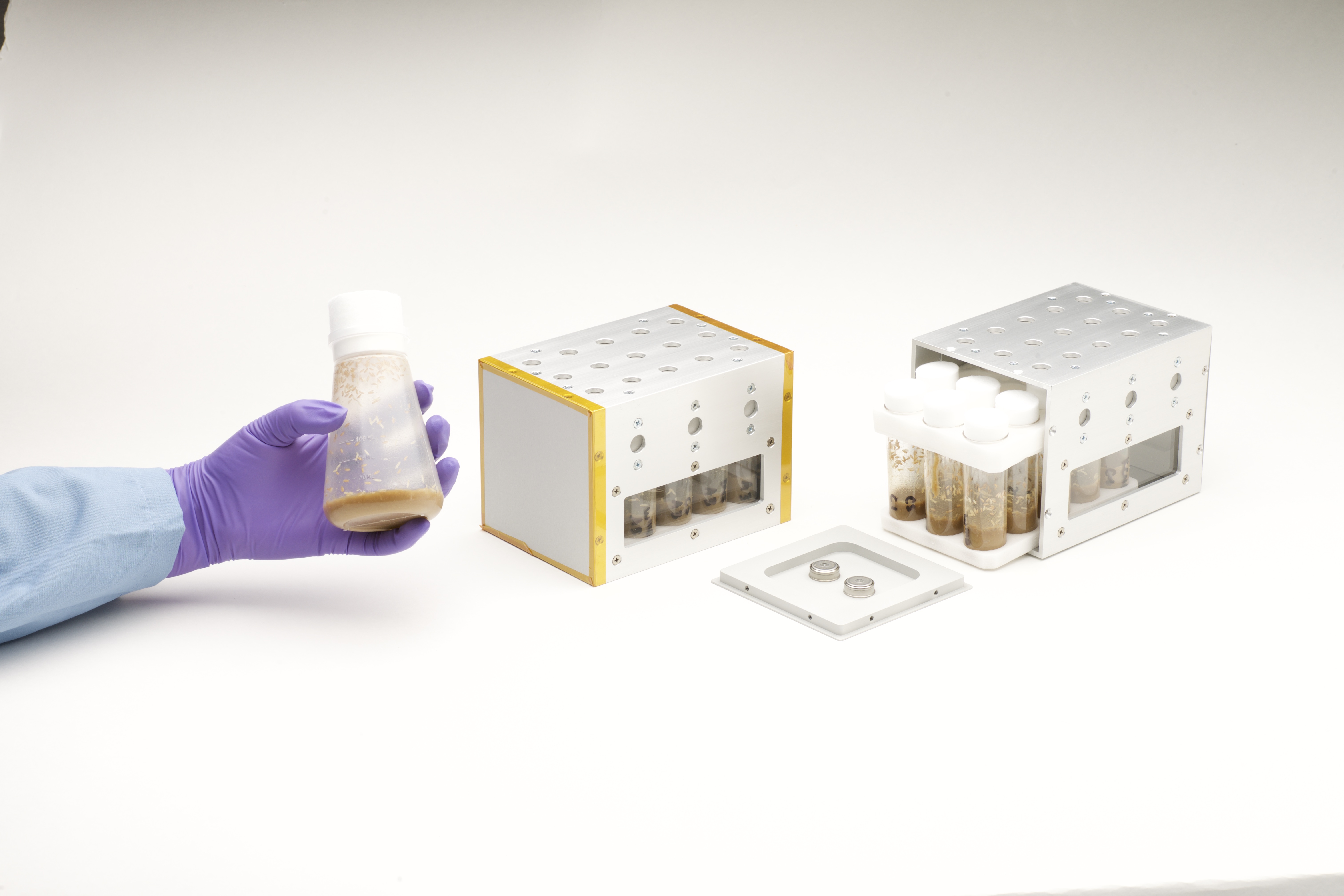
The Vented Fly Box holds and safely transports vials containing flies and fly food. It includes environmental sensors that monitor temperature and relative humidity.
NASA/Dominic Hart
When it comes to helping NASA scientists better understand the effects of space travel on the human body, fruit flies are the heavyweights of experiments in weightlessness. Because humans and fruit flies share a lot of similar genetic code, they squeeze a lot of scientific value into a conveniently small, light package.
Through a new Space Act Agreement between NASA and Axiom Space, the Vented Fly Box will enable fruit flies (Drosophila melanogaster) to launch aboard a SpaceX Dragon spacecraft from NASA’s Kennedy Space Center in Florida. These tiny crew members will join the Axiom Mission 4 crew for scientific investigations on the International Space Station. The goal is to advance research into how spaceflight impacts DNA repair, a key factor in astronaut health on long-term space missions.
For decades, NASA has iterated and improved these specialized habitats to safely house generations of fruit flies for their trips to and from space. As the go-to organism for many of its studies, NASA gained unique knowledge and carefully finessed the steps astronauts take to perform the most efficient and rewarding life science experiments in space.
The study is supported by NASA’s Ames Research Center in California’s Silicon Valley and Axiom Space.
This Aeronautics Research Mission Directorate (ARMD) solicitations page compiles the opportunities to collaborate with NASA’s aeronautical innovators and/or contribute to their research to enable new and improved air transportation systems.
Most opportunities to participate in research are officially announced through the Web-based NASA Solicitation and Proposal Integrated Review and Evaluation System, better known as NSPIRES. You are encouraged to visit the NSPIRES web site, create an account, and sign up for automated email announcements.
Other types of collaborative opportunities, such as those involving Requests for Information or academic research contests, also are included on this page.
This page has four major sections:
Quick list of open solicitations with key dates listed.
This announcement solicits proposals from accredited U.S. institutions for research training grants to begin the academic year. This Notice of Funding Opportunity is designed to support independently conceived research projects by highly qualified graduate students in disciplines needed to help advance NASA’s mission, thus affording these students the opportunity to directly contribute to advancements in STEM-related areas of study. These opportunities are focused on innovation and the generation of measurable research results that contribute to NASA’s current and future science and technology goals.
Research proposals are sought to address the key challenges summarized in the Elements section at the end of the Amendment 1 document, and which reference NASA’s Hypersonic Technology project.
UPDATE for June 6: Reflecting the Fiscal Year 2026 budget changes, the Transformational Tools & Technologies project opportunities originally described in this announcement were cancelled. Proposals citing this project will not be evaluated.
Notices of Intent are not required.
A budget breakdown for each proposal is required, detailing the allocation of the award funds by year. The budget document may adhere to any format or template provided by the applicant’s institution. Two pre-proposal teleconferences for potential proposers will be held and meeting links will be posted on NSPIRES.
NASA’s University Leadership Initiative (ULI) provides the opportunity for university teams to exercise technical and organizational leadership in proposing unique technical challenges in aeronautics, defining multi-disciplinary solutions, establishing peer review mechanisms, and applying innovative teaming strategies to strengthen the research impact.
Research proposals are sought in six ULI topic areas in Appendix D.4.
Topic 1: Safe, Efficient Growth in Global Operations
Topic 2: Innovation in Commercial High-Speed Aircraft
Topic 3: Ultra-Efficient Subsonic Transports
Topic 4: Safe, Quiet, and Affordable Vertical Lift Air Vehicles
Topic 5: In-Time System-Wide Safety Assurance
Topic 6: Assured Autonomy for Aviation Transformation
This NASA Research Announcement will utilize a two-step proposal submission and evaluation process. The initial step is a short mandatory Step-A proposal, which is due June 26, 2025. Those offerors submitting the most highly rated Step-A proposals will be invited to submit a Step-B proposal. All proposals must be submitted electronically through NSPIRES at https://nspires.nasaprs.com. An Applicant’s Workshop will be held on Thursday April 30, 2025; 1:00-3:00 p.m. ET (https://uli.arc.nasa.gov/applicants-workshops/workshop9) (Page will be live closer to the event.)
An interested partners list for this ULI is at https://uli.arc.nasa.gov/partners. To be listed as an interested lead or partner, please send an email to hq-univpartnerships@mail.nasa.gov with “ULI Partnerships” in the subject line and include the information required for the table on that web page.
NASA’s University Student Research Challenge (USRC) seeks to challenge students to propose new ideas/concepts that are relevant to NASA Aeronautics. The challenge will provide students from accredited U.S. colleges or universities with grants for their projects, as well as the challenge of raising cost share funds through a crowdfunding campaign. The process of creating and implementing a crowdfunding campaign acts as a teaching accelerator — requiring students to act like entrepreneurs and raise awareness about their research among the public.
The solicitation goal can be accomplished through project ideas such as advancing the design, developing technology or capabilities in support of aviation, by demonstrating a novel concept, or enabling advancement of aeronautics-related technologies.
Notices of Intent are not required for this solicitation.
Proposals for Cycle 3 are due June 26, 2025.
Proposals can also be submitted later and evaluated in the second and third cycles.
The USRC Q&A/Info Session and Proposal Workshop will be held on the days/times below. Please join us on TEAMS using the Meeting Link, or call in via +1 256-715-9946,,317928116#.
USRC Cycle
Information Session/Q&A Date
Proposal Due Date
Cycle 1
Sept. 20, 2024 at 2 pm ET
Nov. 7, 2024
Cycle 2
Jan. 27, 2025 at 2 pm ET
March 13, 2025
Cycle 3
May 12, 2025 at 2 pm ET
June 26, 2025
The Project F.I.R.E. team receives their “Future Game-Changer” award during the 2024 Gateways to Blue Skies forum held at NASA’s Ames Research Center in California. Gateways to Blue Skies is one of several Aeronautics Innovation Challenges open to the academic community.
NASA / Brandon Torres
Aeronautics Innovation Challenges – OPEN
NASA’s nationwide team of aeronautical innovators are committed to giving students of all ages opportunities to solve some of the biggest technical challenges facing the aviation community today. Through NASA-sponsored challenges and competitions, students representing multiple disciplines will put their skills to work by designing and building solutions to real-world problems.
NASA’s Advanced Capabilities for Emergency Response Operations (ACERO) project used this request for information to identify technologies that addressed current challenges facing the wildland firefighting community. NASA was seeking information on data collection, airborne connectivity and communications solutions, unmanned aircraft systems traffic management, aircraft operations and autonomy, and more. This would support development of a partnership strategy for future collaborative demonstrations.
Interested parties were requested to respond to this notice with an information package submitted via https://nari.arc.nasa.gov/acero-rfi no later than 4 pm ET, October 15, 2023. Submissions were accepted only from U.S. companies.
This request for information is being used to gather market research for NASA to make informed decisions regarding potential partnership strategies and future research to enable Advanced Air Mobility (AAM). NASA is seeking information from public, private, and academic organizations to determine technical needs and community interests that may lead to future solicitations regarding AAM research and development.
This particular RFI is just one avenue of multiple planned opportunities for formal feedback on or participation in NASA’s AAM Mission-related efforts to develop these requirements and help enable AAM.
The respond by date for this RFI closed on Feb. 1, 2025, at 6 p.m. EST.
The announcement solicited proposals from accredited U.S. institutions for research training grants to begin the academic year. This Notice of Funding Opportunity was designed to support independently conceived research projects by highly qualified graduate students, in disciplines needed to help advance NASA’s mission, thus affording these students the opportunity to directly contribute to advancements in STEM-related areas of study. Advanced Air Vehicle Program fellowship opportunities are focused on innovation and the generation of measurable research results that contribute to NASA’s current and future science and technology goals.
Research proposals were sought to address key challenges provided in Elements of Appendix A.8.
A budget breakdown for each proposal was required, detailing the allocation of the award funds by year. The budget document could adhere to any format or template provided by the applicant’s institution.
The proposal for the fuel injector design aimed to establish current state-of-the-art in low NOx supersonic cruise while meeting reasonable landing take-off NOx emissions. The technology application timeline is targeted for a supersonic aircraft with entry into service in the 2035+ timeframe.
Proposals were due by May 31, 2024 at 5 pm EDT.
NASA Research Opportunities in Aeronautics
Competition for NRA awards is open to both academia and industry.
The current open solicitations for ARMD Research Opportunities are ROA-2024 and ROA-2025.
Here is some general information to know about the NRA process.
NRA solicitations are released by NASA Headquarters through the Web-based NASA Solicitation and Proposal Integrated Review and Evaluation System (NSPIRES).
Participation is open to all categories of organizations, including educational institutions, industry, and nonprofits.
Any updates or amendments to an NRA is posted on the appropriate NSPIRES web pages as noted in the Amendments detailed below.
ARMD sends notifications of NRA updates through the NSPIRES email system. In order to receive these email notifications, you must be a Registered User of NSPIRES. However, note that NASA is not responsible for inadvertently failing to provide notification of a future NRA. Parties are responsible for regularly checking the NSPIRES website for updated NRAs.