NASA Sets Coverage for First Artemis Crewed Mission Around Moon

A variety of prelaunch, launch, and mission events for NASA’s Artemis II mission around the Moon will stream online. The agency is targeting no earlier than Wednesday, April 1, for the test flight during a two-hour window that opens at 6:24 p.m. EDT, with additional launch opportunities through Monday, April 6.
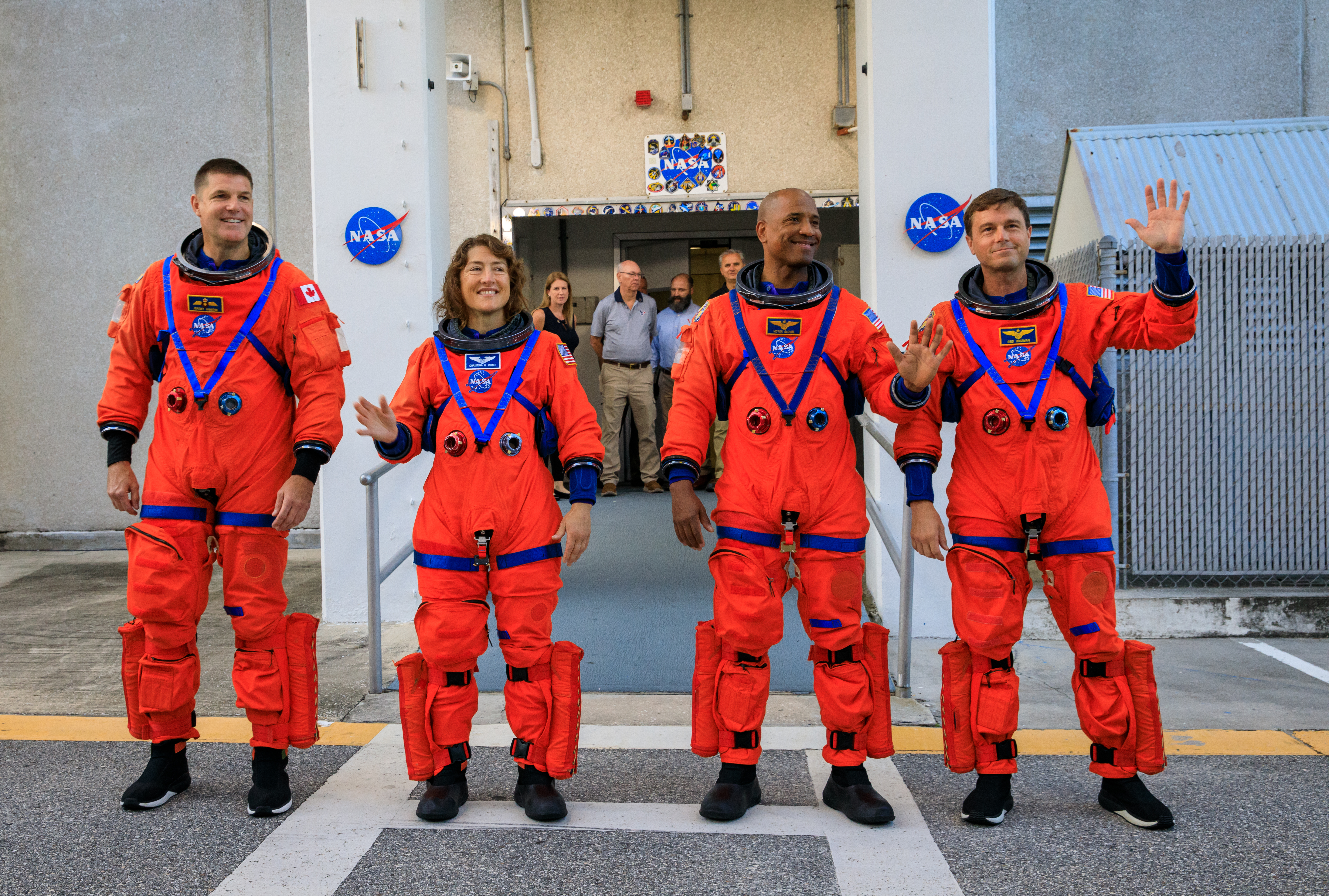
Artemis II is NASA’s first crewed mission under the Artemis program and will launch from the agency’s Kennedy Space Center in Florida. It will send NASA astronauts Reid Wiseman, Victor Glover, Christina Koch, and CSA (Canadian Space Agency) astronaut Jeremy Hansen on an approximately 10-day journey around the Moon. Among objectives, the agency will test the Orion spacecraft’s life support systems for the first time with people and lay the groundwork for future crewed Artemis missions.
Briefings, events, and 24/7 mission coverage will stream on the agency’s YouTube channel, and events will each have their own stream closer to their start time. Learn how to watch NASA content through a variety of online platforms, including social media.
The date and/or time of all events are subject to change. A full listing of coverage activities for Artemis II is available online:
The following highlighted prelaunch and launch events are all listed in Eastern time:
Friday, March 27
- 2:30 p.m.: Agency leadership, including NASA Administrator Jared Isaacman, along with CSA (Canadian Space Agency) President Lisa Campbell, and other leaders, will greet the astronauts as they arrive at NASA Kennedy. The Artemis II crew members will answer questions from media in attendance.
Sunday, March 29
- 9:30 a.m.: The Artemis II crew members will virtually answer reporters’ questions from their quarantine facility.
- 2 p.m.: NASA will hold a news conference to provide a status update for launch.
Monday, March 30
- 5 p.m.: Following a mission management meeting, NASA will host a news conference to provide an update on launch preparations.
Tuesday, March 31
- 1 p.m.: NASA will hold a prelaunch news conference.
Wednesday, April 1
- 7:45 a.m.: Coverage of tanking operations to load propellant into NASA’s (SLS) Space Launch System rocket begins, including views of the rocket and audio from a commentator.
- 12:50 p.m.: NASA+ coverage of launch begins. Coverage will continue on YouTube after Orion’s solar array wings deploy in space.
- Approximately two-and-a-half hours after launch, NASA will hold a postlaunch news conference after the SLS rocket’s upper stage performs a burn to send Orion and its crew to high Earth orbit.
Mission coverage
NASA’s real-time coverage will continue throughout the mission on YouTube. The agency also will provide a separate live stream of views from the Orion spacecraft as bandwidth allows.
The agency will provide daily mission status briefings from NASA’s Johnson Space Center in Houston beginning Thursday, April 2, except for April 6, due to lunar flyby activities.
The crew will participate in live conversations throughout the mission. NASA will provide the exact times of each of these downlink events in the Artemis blog and on the agency’s launch events page.
To participate virtually in briefings, media must RSVP no later than two hours before the start of each briefing to the NASA Johnson newsroom at: jsccommu@mail.nasa.gov.
NASA website launch, mission coverage
Updates during the launch countdown and throughout the mission will be posted on the Artemis blog.
All the latest imagery will be available at: Artemis II Multimedia
To track Orion in space, visit: nasa.gov/trackartemis
Attend launch virtually
Members of the public may register to attend the launch virtually. NASA’s virtual guest program for this mission includes curated launch resources, notifications about related opportunities or changes, and a stamp for the NASA virtual guest passport following launch.
Audio-only launch coverage
Media may listen to the audio-only coverage of the tanking and launch broadcast by dialing 256-715-9946, passcode 682 040 632. For those in Brevard County on the Space Coast, launch audio also will be available on Launch Information Service and Amateur Television System’s VHF radio frequency 146.940 MHz and KSC Amateur Radio Club’s UHF radio frequency 444.925 MHz, FM mode.
The deadline for media accreditation for in-person coverage of launch and mission events has passed. The agency’s media credentialing policy is available online. For questions about media accreditation at NASA Kennedy, please email: ksc-media-accreditat@mail.nasa.gov. For questions about media accreditation at NASA Johnson, please email: jsccommu@mail.nasa.gov.
For information on obtaining feeds, email the NASA+ programming team: nasa-dl-nasaplus-programming@mail.nasa.gov.
As part of Golden Age of innovation and exploration, NASA will send Artemis astronauts on increasingly difficult missions to explore more of the Moon for scientific discovery, economic benefits, and to build on our foundation for the first crewed missions to Mars.
Learn more about NASA’s Artemis program by visiting:
-end-
Cheryl Warner / Lauren Low
Headquarters, Washington
202-358-1600
cheryl.m.warner@nasa.gov / lauren.e.low@nasa.gov
Tiffany Fairley
Kennedy Space Center, Florida
321-747-8306
tiffany.l.fairley@nasa.gov
Chelsey Ballarte
Johnson Space Center, Houston
281-483-5111
chelsey.n.ballarte@nasa.gov
Powered by WPeMatico
Get The Details…
Jennifer M. Dooren